Showing posts with label Smallpox. Show all posts

Friday, October 7, 2016

Remembering A River

A view of the Cannonball River looking west. 
Remembering A River
Significant Mentions In Historic Resources
By Dakota Wind 
Updated on Nov. 12, 2016
Updated on Dec. 11, 2016
Updated on Feb. 13, 2017
Updated on Feb. 1, 2018
Cannonball, ND – The Lakȟóta people keep their collective memory alive in pictographic records called winter counts. One such winter count, the Brown Hat Winter Count, reaches back to what ethnologists and historians might call “myth-history,” to circa 901. This history reaches back hundreds of years and recalls the arrival of the horse in 1692, the first horse stealing raid in 1706, inter-tribal conflict, contact with traders, smallpox, starfalls, eclipses, comets, sun dances, white bison hunts, conflicts with soldiers, treaties, the arrival of settlers, the boarding school and reservation era, and survival.

If the Cannonball River were excluded from primary resources like journals, maps, and winter counts, our North Dakota history would be poorer for it. There is a continuous cultural occupation of this Missouri River tributary reaching back to circa 1300 through the tribal histories of the Mandan, Arikara, Cheyenne, Yanktonai Dakota, and Hunkpapa Lakota.


Following my viewing of the Class III survey report, I contacted the Chief Archaeologist at the North Dakota State Historic Preservation Society about several things that were missing. Mr. Picha's replied, "Dakota, Thank you. Mentions also appear in J. H. Howard's (1979) British Museum Winter Count. Sincerely, Paul." Mr. Picha acknowledges the missing information by mentioning yet another primary resource document. 

I scheduled a viewing of the Dakota Access Pipeline Class III survey report with the North Dakota State Historic Preservation Office at 4:00 PM on March 1, 2016. The report is in three thick volumes, and there was no possible way that I could view the entire thing in one sitting, however, I narrowed my search to the Cannonball River and Beaver Creek. According to the authors of this report, they admitted to no tribal consultation. They don’t have to, because the pipeline does not physically cross the reservation border. The report doesn’t mention much in the way of history and culture. What is mentioned, can’t be shared, because it may lead to the destruction of the resource.


The Lakota world view perspective places south as the orienting direction. Here is the Missouri River, the Cannonball River on the right (west), and two Missouri tributaries on the left (east) (Beaver Creek, top; Long Lake Creek, bottom).

What it doesn’t say needs to be shared. The report does not mention the flood of 1825 opposite of the mouth of the Cannonball River - thirty lodges, or about 150-180 people drowned. There was no mention of The Charger’s last camp on Beaver Creek either. The Charger was a major historic figure in the War of 1812, he fought in three conflicts in Ohio, met President Van Buren, met King George III, led as many as 700 Dakȟóta-Lakȟóta under Col. Leavenworth’s command of the Missouri Legion in 1823 in the first ever US military campaign on Plains Indians against the Arikara. A major historic figure? A former US president and an English king certainly thought so.


The Charger (inset) and the location of his last winter camp on Beaver Creek where he died the winter of 1839-1840. 

These few things were brought to the attention an individual at the ND SHPO on March 1, 2016, along with where he could find this information. The following day, that individual responded that this info is also be found in the British Museum Winter Count, in London, England.

The north and south banks of the Cannonball River are rife with physical evidence of historic and cultural occupations of people who are still here. This physical evidence of village remains and midden mounds are complemented by surviving oral tradition; there are various mentions in historic journals from English resources (i.e. John Evans) to American resources (i.e. Manuel Lisa, Corps of Discovery, etc.). As to whether or not the historic occupations of the Arikara, Cheyenne, and Mandan Indians ever interred their deceased in the vicinity of the Cannonball River mouth, it is absolutely preposterous to say that there are no burial grounds nearby – to say so would be to suggest that no one ever died in any of the cultural occupations. Alfred Bowers’ Mandan informants told him that their ancestors buried their deceased “in earlier times.”


The Sitting Rabbit Map of the Missouri River. The Cannonball River is listed on this map as "Big River." 

The Sitting Rabbit map of the Missouri River, from the North Dakota-South Dakota border to the North Dakota-Montana border, was commissioned by Orin Libby in 1906. At the time, Libby was the Secretary of the State Historical Society of North Dakota (SHSND). Libby sought out Sitting Rabbit, a Mandan Indian man, to capture the geography of the Missouri River as they knew it. Sitting Rabbit didn’t disappoint in his efforts. In fact, the Mandan Indian villages at the mouth of the Cannonball River, both the north and south bank villages, are called the Big River Villages. The Mandan Indian name of the Cannonball River is the Big River. This precious map is still in the collections of the SHSND. The SHSND has graciously uploaded this map for public viewing on their ND Studies website.


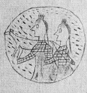
A Cheyenne (left) meets a Lakota (right) on the hunt. The Cheyenne makes the sign for "Finger Cutter" to the Lakota. The graphic is by French artist Jean Marcellin.

According to Col. A.B. Welch's "Seven Fires," Sometime around 1750, the Šahíyela (Red Talkers; Cheyenne) were compelled by the Lakȟóta to cross the Missouri River at the mouth of the Cannonball River. The Šahíyela were hard pressed to make peace with the Lakȟóta or be exterminated, so they embraced their old foe and became allies. A great inter-tribal adoption, cemented by marriages, was arranged. But not all the Lakȟóta were keen to make an ally of a former enemy. 


The origin of the Sičáŋǧu began with a conflict at the Cannonball River.

The Brown Hat Winter Count (aka Baptiste Good Winter Count; Sičáŋǧu, “Brulé”) in the winter count collections at the National Museum of The American Indian in Washington DC, has been made available in its entirety online. This winter count recalls 1762-1763 as the “people were burnt winter.” The entry details a great prairie fire that caught up to their village. Many people and horses were killed in this fire. Survivors themselves were burnt about their legs and made it through this trial by jumping into Long Lake. This band of Lakȟóta had fought the Cheyenne in the Cannonball area. The Cheyenne had retaliated by crossing the Missouri River at the mouth of the Cannonball River and tracking the Lakȟóta along Long Lake Creek, where they set fire to the plains. The late Albert White Hat Sr. (Rosebud; Sičáŋǧu), recalled the oral tradition of the Sičáŋǧu as taking place in the Bismarck region. The conflict which resulted in the formation of the Sičáŋǧu began at the mouth of the Cannonball River. The identity of one of the tribes of the Očhéthi Šakówiŋ (The Seven Council Fires; “The Great Sioux Nation”) tied to this location is significant.


John Evans composed this map of his journey up the Missouri River. Roughly half the Corps of Discovery's expedition was already mapped before they came. 

The Beinecke Library Map, at Yale, CT, the only evidence of John Evans travels (his journals may have been destroyed or lost) provides the only testimony of his journey on the Upper Missouri River. This map was referenced and annotated by the Corps of Discovery. Evans recorded on his map a series of streams, many unknown to him by name; one of the outstanding streams he recorded was the “Bomb River,” or the Cannonball River.

The Corps of Discovery mention the Cannonball River as “La Bullet” on October 18, 1804. Referencing Evans’ map, Captain William Clark walked that evening in search of the remarkable places mentioned by Evans, but couldn’t find them, though by then, the Corps’ campsite was north of the mouth of the Cannonball River. Co-Captain Meriwether Lewis noted on this same date that the cannonball concretions were “of excellent grit for Grindstones,” and had his men select one to “answer for an anker.”


The Pictographic Bison Robe details a huge inter-tribal conflict on the Northern Plains.

The Pictographic Bison Robe, at the Peabody Museum of Archaeology and Ethnology at Harvard University, MA, details the intertribal conflicts amongst the Arikara, Mandan, Hidstsa, Hunkpapa Lakota, and Yanktonai Dakota in the Heart River and Cannonball River area along the Missouri River during the 1790s. This same robe details one of many conflicts between the tribes of the Upper Missouri River which concluded in the 1803 Battle of Heart River, which saw the expansion of the Huŋkphapȟa territory. This conflict is remembered in the Drifting Goose Winter Count (aka John K. Bear Winter Count) as Tȟa Čháŋte Wakpá ed okíčhize, or “There was a battle at Heart River.” The expansion of Huŋkphápȟa territory is significant. This territorial boundary is recognized in the 1868 Fort Laramie Treaty.

Ensign Nathaniel Pryor, a sergeant of the Corps of Discovery during the expedition, recorded on September 9, 1807, that the Arikara and Mandan were at war. The Mandan had killed two Arikara at the mouth of the Cannonball River. Testimony of the conflict at Cannonball River was delivered to Pryor at the Grand River by the Lakȟóta. Pryor’s previous experience with the Arikara and Lakȟóta made him aware that the best policy was to place every confidence in their word; they had no reason to lie.

Manuel Lisa, a fur trader of the American Fur Company, recorded that tensions were high on the Northern Plains among tribes who were pro-English trade, those who were pro-American trade, and American Fur Company trappers in the fall of 1812. The Crow and Lakȟóta had killed American trappers, the Hidatsa had stolen American Fur Company horses, the Arikara had indiscriminately killed trappers be they English or American, and the Cheyenne had robbed and whipped American Fur Company trappers on the Cannonball River.


The native blue flax fascinated Bradbury. 

Botanist John Bradbury made a journey to the Cannonball River in 1811. Bradbury noted late in the day on June 20, the “valley of Cannon-ball River, bounded on each side by a range of small hills, visible as far as the eye can reach; and as they appear to diminish regularly, in the proportion of their distance, they produce a singular and pleasing effect. The Cannon-ball River was muddy at this time; but whether it is constantly so or not, I could not learn. It is here about one hundred and sixty yards wide, but so shallow that we crossed it without swimming. We camped on a very fine prairie, near the river, affording grass in abundance, nearly a yard high. The alluvion of the river is about a mile in breadth from bluff to bluff, and is very beautiful, being prairie, interspersed with groves of trees, and ornamented with beautiful plants, now in flower.” Among Bradbury’s findings was a species of flax he identified as linum perenne. The Lakȟóta know the native blue flax as Čhaŋȟlóğaŋ Nabláǧa (“Hollow-Stem To-Blossom-From-Within”) and employ the seed in their food stock.

Bradbury returned again to the Cannonball River on July 7, 1819, for the express purpose of procuring additional botany specimens.


The location of the 1825 spring flood (Mní wičhát’tÉ) and the name in memorial (Étu Pȟá Šuŋg t’Á) afterward. 


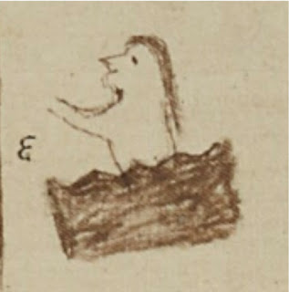
The location and story of the 1825 flood is remembered in the pictographic record. Pictured above is the 1825 entry on the Medicine Bear Winter Count. 


The location and story of same flood is recorded on the Chandler-Pohrt Winter Count for the same year, 1825.

The Blue Thunder Winter Count, the No Two Horns Winter Count, and the High Dog Winter Count, all of which are in the collections at the State Historical Society of North Dakota - the High Dog Winter Count is on display in the Early Peoples Gallery - all recall a devastating flood in the spring of 1825. The High Dog Winter Count remembers the flood as Mní wičhát’tÁ, or “Many died by drowning.” The Blue Thunder Winter Count remembers the flood as Mní wičhát’tÉ, or “Many died by drowning.” According to the High Dog Winter Count, this fatal winter camp was opposite of the mouth of the Cannonball River, and the site is remembered as Étu Pȟá Šuŋg t’Á, or “Dead Horse Head Point.” The Steamboat/Thin Elk Winter Count, in the collections of the Buechel Museum at the St. Francis Indian School on the Rosebud Indian Reservation in South Dakota, records that it was thirty lodges of Iháŋktȟuŋwaŋna Dakȟóta who drowned in the Horsehead Bottom flood. This flood story and location is also remembered in the Medicine Bear Winter Count at the Hood Museum at Darthmouth College, Hanover, NH. This information is repeated for the same year in the Chandler-Pohrt Winter Count which is located at the Detroit Museum of Arts, Detroit, MI.

Prince Maximilian von Wied-Neuwied travelled into the interior of North America during the summer of 1833. Wied-Neuwied has written probably the most about the Cannonball River than any previous or post visitors. An excerpt is shared here: “On the north side of the mouth, there was a steep, yellow clay wall; and on the southern, a flat, covered with poplars and willows. This river has its name from the singular regular sand-stone balls which are found in its banks, and in those of the Missouri in its vicinity. They are of various sizes, from that of a musket ball to that of a large bomb, and lie irregularly on the bank, or in the strata, from which they often project to half their thickness when the river has washed away the earth; they fall down, and are found in great numbers on the bank. Many of them are rather elliptical, others are more flattened, and others flat on one side, and rather convex on the other. Of the perfectly spherical balls, I observed some two feet in diameter.”


An entry from the Long Soldier Winter Count for 1835-36. A copy is available for viewing at the Sitting Bull College Library. 

The Long Soldier Winter Count entry for 1835-36 recorded an Arikara camp on the Cannonball River. The Húŋkphapȟa Lakȟóta went to the Arikara camp to trade for wagmíza (corn). The Arikara, not wanting the Lakȟóta around, perhaps owing to the part the Lakȟóta played in the Arikara War of 1823, killed six of the Lakȟóta. 

A beautiful photo of the Rock Wren by Glenn Bartley. See and hear more of this bird on the Audubon page for the Rock Wren

John James Audubon visited the Cannonball River on June 5, 1943, and wrote of "the very remarkable bluffs." According to Audubon, the Cannonball River was formerly a good place for beaver. He saw Iǧúǧaothila (Rock Wren) on the bluffs, a prairie fire, and noted that the water tasted good.


General Sully rendered this image of the Whitestone Hill conflict. The hills were dotted with creamy white stone, glacial deposits from the last ice age, and could be seen glittering from the distant flat horizon. 

In September of 1863, General Alfred Sully lead an assault on the Siouan encampment at Whitestone Hill as part of the punitive campaigns organized by General Pope to make Americans feel safe following the 1862 Minnesota Dakota Conflict, and to open the frontier for settlement - in particular, to open the frontier for veterans returning from the Civil War. Sully's command killed as many as 200 (mostly women and children) and took 256 prisoners (mostly women and children). Survivors, those who escaped, turned west and crossed the Missouri River at the Cannonball confluence. 


Long Soldier mentions a conflict at the Cannonball River between the Lakȟóta and Hóhe.

A second entry on the Long Soldier Winter Count cites a conflict at the Cannonball River between the Lakȟóta and Hóhe (Assiniboine) in 1862-63. Twenty Assiniboine came on the warpath, there was a battle there, and they hid behind the cannonball concretions. The circle tells us that the Assiniboine were surrounded and fired upon. The fox image which overlays the Assiniboine tells us they fought with guile.


Capt. Seth Eastman painted this scene of Fort Rice, Dakota Territory.

On July 29, 1864, after spending two weeks hastily constructing Fort Rice, General Sully took his command of 2200 soldiers, which included a detachment of Winnebago Indian scouts, and ascended the Cannonball River on the south bank, his punitive campaign on the Isáŋyathi Dakȟóta anew. Known or unknown, Sully also marched against the Thítȟuŋwaŋ Lakȟóta (Húŋkpapȟa, Itázipčho, Sihásapa, and Mnikȟóžu), and Iháŋktȟuŋwaŋna Dakȟóta, two Siouan groups who had nothing to do with the 1862 Minnesota Dakota Conflict. Sully received a dispatch from Fort Rice at midnight on July 22 that the Dakȟóta were on the Knife River. The next day Sully’s command crossed the Cannonball River near present-day communities of Porcupine and Shields, ND.


Gall was bayoneted by a soldier at Fort Berthold. 

A third entry from the Long Soldier Winter Count indicates that the Húŋkpapȟa were camped at the Cannonball River in 1866-67. Gall was taken by soldiers that winter to Fort Berthold where they stabbed him. Gall was left for dead and the camp moved on. What makes this tale remarkable is that Gall walked to the Húŋkpapȟa camp at the Cannonball River and recovered. 

In 1878, the Huŋkphápȟa chief, Ištá SápA (“Black Eye/s”), met with William Wade, a cattle rancher on the Cannonball River, and shared this about the terrible 1825 flood: “...we camped on this bottom land just below here...it was the Wolf Month [February] and it had been warm for a long time. One night the water started coming in over the ground from the river and before we could get to higher ground we were surrounded by water and ice chunks. Our only chance was to get to high ground before we would all be covered up with water. We tried to carry our tepees and supplies but finally had to leave them and many of the women were drowned trying to save their children. Most all our old people drowned and many others. Most all our horses went under and you can still see their heads (skulls) laying [sic] along at the foot of the hills after so many, many years. Two Bears (Mato Nopa) a Yankton chief [sic], saved the lives of several women and children by carrying them from camp to the higher ground.”

William Wade’s daughter, Mamie, met her share of pre-reservation Dakȟóta and Lakȟóta people. Among them was Annie Skye. Skye relayed to the younger Wade that smallpox struck the Lakȟóta in 1837. They were camped at the mouth of the Cannonball River when “out of a clear blue sky smallpox hit them. After the death of several of their number, who were put to rest up on platforms suspended in trees, they decided to move away from this infested locality.”

Dr. Harriett Skye, Annie Skye’s granddaughter, offers a contemporary perspective on current events near the Cannonball River: “I believe that as long as they remain peaceful and unarmed, and each day they are there, is a win. This kind of action confuses those who would come in with their guns and armor because their intent is to kill. They arrested people who were praying, but the powers that be know that the world is watching, but more importantly, know that our Ancestors are watching because they fought and died so we could be here. This struggle is everyone’s struggle to maintain our clean water. Water is life.” Dr. Skye was inducted into the North Dakota Heritage Center’s Native American Hall of Honor in September, 2016.


Dr. Fenn's "Encounters At The Heart Of The World." Get yourself a copy.

Dr. Elizabeth Fenn, Pulitzer Prize winning author of “Encounters at The Heart of The World: A History of The Mandan People,” writes that the Huff phase - located between the Cannonball River and Heart River in a time frame from about circa 1300 to about 1450 - was when and where the Mandan became the Mandan. They developed the Okipa ceremony in this location during this time. The South Cannonball site was unprotected, that is, there were no palisade walls, nor defensive moats surrounding their village there. The fortifications at the North Cannonball site may well represent a key transformation in plains village life, as drought caused strife in the Missouri River valley. This may have been cause for the Mandan to move closer together - and build fortifications - for safety. But we need archaeological study to sort these things out.

By the time Mandans moved north from the Cannonball area to Huff and the Heart River, they had embraced the key trait that made them Mandan: the Okipa ceremony, with its multi-day reenactment of their own rich history. The Cannonball area, according to Fenn, represents “the oldest Mandan cultural horizon.”


One of Deloria's thought-provoking works. Another one is "Custer Died For Your Sins." 

The late Vine Deloria Jr. essayed that for many Americans, “the first and most familiar kind of sacred lands are places to which we attribute sanctity because the location is a site where, within our own history, something of great importance has taken place. Unfortunately, many of these places are related to instances of human violence. Every society needs these kinds of sacred places because they help to instill a sense of social cohesion in the people and remind them of the passage of generations that have brought them to the present. A society that cannot remember and honor its past is in peril of losing its soul. Indians, because of our considerably longer tenure on this continent, have many more sacred places than do non-Indians.”

“A second category of sacred lands has a deeper, more profound sense of the sacred. It can be illustrated in…[when] Joshua led the Hebrews across the River Jordan into the Holy Land. After crossing, Joshua selected one man from each of the Twelve tribes and told him to find a large stone. The twelve stones were then placed together in a monument to mark the spot where the people had camped after having crossed the river successfully. In the crossing of the River Jordan, the sacred or higher powers have appeared in the lives of human beings...the essence of the event is that the sacred has become a part of our existence.”

“It is not likely that non-Indians have had many of these kinds of religious experiences, particularly because most churches and synagogues have special rituals that are designed to cleanse the buildings so that their services can be held there untainted by the natural world. Non-Indians simply have not been on this continent very long; their families have rarely settled in one place for any period of time so that no profound relationship with the environment has been possible.”

Deloria concluded: “The third kind of sacred lands are places of overwhelming holiness where the Higher Powers, on their own initiative, have revealed Themselves to human beings. We can illustrate this point in the Old Testament narrative. Moses spent time herding sheep on Mount Horeb. One day to his amazement [he] saw a bush burning with fire but not being consumed by it. Approaching this spot, Moses was startled when the Lord spoke to him. ‘Put off thy shoes, for the place where thou standest is holy ground.’ This tradition tells us that there are places of unquestionable, inherent sacredness on this earth, sites that are holy in and of themselves. These holy places are locations where people have always gone to communicate and commune with higher powers.”


Wood's book details the Huff Phase of the Mandan Indians, which also includes some narrative of the North Cannonball site. An aerial view of this site is within these pages.

Dr. Ray Wood, renowned expert in Plains Indian cultural and archaeological sites on the Upper Missouri River and whose first-hand field experience goes back before the dams of the 1950s, interprets the data from John Evans 1796 map in regard to the Cannonball River locality that what Evans recorded as “Jupiter’s Fort” is without a doubt a prehistoric Mandan village. According to Wood’s findings regarding the North Cannonball site, “Not only was it a defensive setting, but the village was also fortified by a curving ditch that isolated a level upland spur from the adjoining upland. The village today is badly disturbed by plowing, but from the air one can clearly see the fortification ditch and the numerous bastions protruding from it. Little wonder that Evans referred to it as a fort…” In his “Prologue To Lewis & Clark: The Mackay And Evans Expeditions,” Dr. Wood essays the number of remarkable Indian village sites north of the Cannonball River. Remarkable. Extraordinary. Outstanding. Significant.

The ND SHPO conducted a follow-up survey west of HWY 1806 and found that no significant sites were destroyed. The physical evidence, or lack thereof, cannot be disputed. According to the chief archaeologist’s published note, he and his associates were looking west of HWY 1806, perhaps because Mr. Tim Mentz conducted his own survey and called attention there with his findings. The North Cannonball site, and the mouth of the Cannonball River, the confluence of history and culture, is east of HWY 1806.


The Cannonball Ranch was a main stop in North Dakota's history. 

In 1999, the Cannonball Ranch was inducted into the North Dakota Cowboy Hall of Fame. It’s one of the oldest ranches in North Dakota. According the ND Cowboy of Fame, the ranch served as a gathering point as early as 1865. The ranch included a hotel, a general store, a ferry crossing, a steamboat landing and fueling station, a military telegraph station for Fort Rice, and a stage line to the Black Hills in the 1870’s and 1880s. The ranch also included two houses, a barn, a blacksmith shop, a bunk-house, an ice house, a laundry, and tennis court.

The North Dakota Cowboy Hall of Fame’s strict criteria for eligibility to be recognized is that a ranch must have been “instrumental in creating or developing the ranching business, traditions, and lifestyles of North Dakota’s western heritage and livestock industry.”

In 2010, Walmart planned to construct a supercenter near Wilderness Battlefield (a Civil War battle ground) and people invested in the history of that site grew concerned. Eventually, enough people held that ground as sacred and historical that plans for the supercenter were dropped in January 2011. Coincidentally, Walmart and state officials had argued that nothing significant occurred on that site. 

The sum of the north bank of the Cannonball River with a million years of geological history, 700 years of continual occupation, inter-tribal conflict, smallpox, botany, trade, steamboat traffic, US military history, and early ranching, have made that location significant.


Mr. Leroy Curly (Cheyenne River Sioux Tribe) developed a Lakota alphabet in the 1980's. I employed this alphabet executed in a brush script using acrylic on watercolor. 

Spiritual pilgrimages were conducted on the plateaus of the “Hummit.” There would be little to no traces of these vision quests, and there shouldn’t be. People went to pray, not leave evidence. In September of 2016, the Presiding Bishop of the Episcopal Church, Rt. Rev. Curry, made a pilgrimage of his own to the Cannonball. He listened and prayed with the community there. Curry’s visit calls to mind Psalm 99:9, “Exalt the Lord our God, and worship at his holy hill; for the Lord our God is Holy.” The mystery of creation can be seen there today as the early peoples beheld it.

The Cannonball River, and specifically the North Cannonball site, and its importance to the first nations, to North Dakota, must take into account its religious or spiritual significance, its role in inter-tribal conflicts, its role in the 1837 smallpox epidemic which struck the Húŋkpapȟa, its role as the starting point in Gen. Sully’s 1864 punitive campaign, and the historic Cannonball Ranch.

The Cannonball River, and all its attributes is important to all North Dakota citizens, to new citizens, and most importantly of all, the future. Let us put our minds together, to educate ourselves and one another about the things we hold dear, to resolve to respect our story, our histories, and our sites of significance.

Keúŋkeyapi. That’s what they said. 


Tuesday, July 19, 2011

My Trip to Fort Buford and Back, a Photo Essay

"A village of the Hidatsa tribe at Knife River," by George Catlin.My Trip to Fort Buford and Back
A Photo Essay, Part 1
By Dakota Wind
Hi!  So, I was invited to the 130th Anniversary of Sitting Bull's return from Canada at Fort Buford, a North Dakota State Historic Site. On my way up I thought that I'd stop at some sites along the way. I left my home north of Mandan and crossed the interstate bridge (I had to stop by the State Historical Society of North Dakota and drop off some really important stuff) then I headed north on HWY 85 to Washburn. I wanted to check out Fort Mandan, but the fort was dangerously close to sitting smack in the Missouri - due the flood. The Cottonwood Giftshop was surrounded by an earthen ditch and sandbags. I didn't want to show a North Dakota site when its in such a sad state so I took no pictures. Sorry.  If you don't know about the Lewis and Clark Expedition of 1804-06 and you're American, shame on you and go look it up - however, if you're a foreigner, I can forgive you. The Lakota stole an iron-shod pony from the Corps of Discovery in February 1805 at Fort Mandan, then burned down an old Mandan Indian village to prevent the Corps from mounting chase. 


My first stop on the way to Fort Buford was at Fort Mandan up in Washburn, ND. All the Indians (as if there's a whole bunch of them up there - there's only one) on staff up there were gone. 

So, being that I didn't want to take any pictures of the reconstructed Fort Mandan as it was nearly surrounded by water, I crossed the bridge there in Washburn and made my way to Fort Clark. 

I took the bridge in Washburn across the Missouri River to Fort Clark. 

At Fort Clark, a prominent American Fur Trade Post in the 1820s and 1830s, I stopped to admire the majesty of the Missouri River. The site itself doesn't offer much other than shade and outhouses. Back in the 1830s, a smallpox epidemic struck the Mandan living at the fort and nearly wiped them all out, by 1838, there were maybe only 500 Mandan Indians left. The saddest story I heard about the fort was about a mother who had just given birth. The mother died of smallpox, they wrapped her and her baby up, thinking the baby died as well, and buried them outside the fort. For a day, the people around the fort nearly went mad because they could all hear a baby crying and none could remember where the baby and mother were buried. I was moved to tears the first time I heard this from Amy Mossett, a Mandan Indian from the Fort Berthold Indian Reservation. 


An interpretive sign summing up the activity at the site, and the smallpox epidemic.


If you could see it from above, you'd see depressions of where earthlodges used to be, and outlines of the fort's buildings, including a rectangular ceremonial lodge about 65' x 120', about twice the size the biggest earthlodge at Fort Abraham Lincoln State Park. 


This lone building provides a modest shelter in inclement weather. There's also a log for visitors to sign in, but the size of the building only adds to the solitude of the site. 


From Fort Clark, I went up to Knife River, only a ten minute drive away. I sometimes like to measure my trips by how many songs I can get there in, and this one was about the length of Def Leppard's "Rocket (Extended Atomic Mix)" which is about ten minutes. 


Knife River Indian Villages is designated a National Historic Site. Behind the building and bushes is the site of three Hidatsa Indian villages and a late woodlands linear mound. I used to work here as an Interpretive Ranger. 


The main entrance of the visitor center at Knife River. The main foyer of the building is designed on the ground flood plan of an earthlodge. A roof window lets in natural light as the smoke whole in an earthlodge would too. 


Here's a Hidatsa Indian earthlodge. The entrance faces east, towards the rising sun. An earthlodge typically only lasts about a dozen years due to the wood decaying, but with a cement ring and treated lumber this earthlodge has been standing over twenty years and looks great.


The Hidatsa Indians were an agricultural society. Here is a garden, but due to the odd weather this year in North Dakota, the planting of corn, squash, and beans was put on hold, and tobacco was planted. You can see that it is flourishing with this year's unseasonably wet weather. The Hidatsa would even put up scarecrows too. 


A replica of Four Bears' robe. Four Bears was the last war chief of the Mandan Indians. Even though this rests in a Hidatsa earthlodge, it looks at home. 


Parfleche boxes hang from the ceiling.  I disk is suspended on the leather ties above the parfleche, so that if rodents tried to get at whatever may be in the parfleche (maybe food) they'd slip and fall to the ground. 


Two examples of horse saddles and robe hang on the posts near the entrance of the lodge. The idea that Mandans or Hidatsas bringing their horses into the earthlodge is debated today.  I think they brought their horses in after the 1781 epidemic of smallpox, because there was so few to protect their horses from theft, certainly by Karl Bodmer's and George Catlin's time they did (the 1830s). The low rise and light weight Plains Indian saddles were the basis for General George McClellan's saddle the US Cavalry used in the the latter half of the 1800s. 


Mandan and Hidatsa women produced pottery. Here's a reproduction. 


A bunch of stuff sits on a cattail mat.  I nearly helped myself to that beaded knife sheath. 

A catlinite pipe and stem among other implements (including a wing fan) sit at rest here in the place of honor. The Hidatsa call this spot the Ituka. I nearly took that pipe too, because I'm sure that the Mandan and Hidatsa would want me to have it. 


A bed made of bison robes and elk skins.  A buckskin pillow stuffed with bison hair completes this bed set.


An anvil stone. If one were to look closely and carefully around this stone, one would find flint chips and flakes. The stone has several grooves in the top of it. Its glacial granite from the Canadian Rockies. It was used for nearly ten thousand years to make flint arrowheads, knifes, hatchets, and other tools. 


This is the Sakakawea Site where the Corps of Discovery first encountered Sakakawea.  Natural grasses and flowers were reintroduced to the site back in 2006.  The earthlodge depressions are mowed regularly so that visitors may clearly see where the village used to be.  Jean-Baptiste Charboneau was born here in 1805. 


From Knife River Indian Villages near Stanton, ND, I drove to Dunn Center, or to privately owned land near Dunn Center to pay a visit to the ancient Knife River flint quarry. 


On top of this bluffline is the ancient Knife River flint quarry. Flint was quarried here for about ten thousand years and traded across the North American continent. It is a form of silicon, hard pressed over the ages of the world, and actually began as a plant. This quarry is on private property near the community of Dunn Center, ND. 


From the flint quarry, I took off to Williston State Collge.  I made it with ten minutes to spare for the social and unveiling of the Sitting Bull statue.  I'll post those pictures and my time at Fort Union and Fort Buford next. 

Wednesday, March 16, 2011

On the Plains Before And After Lewis & Clark

Smallpox entry on the Rosebud Winter Count for the year 1819-1820.
Before The Corps of Discovery
The War of 1812 And After

By Dakota Wind
THE GREAT PLAINS - The Sioux came out onto the plains and tested the strength of other nations that were already there. With their claim staked out over much of the present-day Dakotas and Upper Nebraska, southeastern Montana, and northeastern Wyoming, the Sioux land claim had to be defended. The war to win the Black Hills wasn’t over after the Kiowa were pushed out of the area; the Arapaho had to be removed as well. Relations between the Cheyenne and Lakota were nurtured, though with some small fights. 

Battles continued with the Mandan, Hidatsa, and Arikara, who had a very powerful presence on the Upper Missouri and whose strength would be severely tested in 1780-81 with an epidemic of smallpox[i]. The Sioux had been tested long before the Mandan, Hidatsa, and Arikara, with epidemics of the pox, measles, and other diseases since contact with whites began in 1640 in Wisconsin[ii].

The John K. Bear wintercount says that the Dakota were tested by famine in 1689. So pushed to the limit of gnawing hunger that they resorted to eating their dead. The Baptiste Good wintercount says that three lodges, or about thirty people, staved to death. John K. Bear’s entry for 1722 records an epidemic of diarrhea and cramps that struck the entire tribe and the only way to escape it was for everyone to break camp and scatter. Another entry entered in the John K. Bear wintercount in 1733, shows yet another example of cannibalism, while a few years later (1746) another epidemic of disease gripped the Dakota. Baptiste Good records that over the winter of 1755-56, many pregnant women died; this event would reoccur in 1792-93, 1798-99[iii], and later at 1815[iv]. Back in the John K. Bear wintercount we see an entry for 1762, in which an ulcerative disease struck the Sioux. The 1760’s as recorded in the John K. Bear wintercount also show that the Dakota fought amongst themselves, but the fighting probably lasted only a few years, at least until the Sioux would put aside their self-frustrations and took it out on the Mandan in 1771[v]. There is nothing like a war to unite a people and take their focus off their own concerns and displace on others.

The 1700’s see a great many epidemics of disease, stress, and famine striking the Sioux, and yet for the most part, the strength of the other Upper Missouri Indians remained as strong as ever until that epidemic of smallpox hit the Mandan, Hidatsa, and Arikara. That same epidemic is recorded in various L/Dakota wintercounts, yet the Sioux never suffered the loss of people or strength as the other tribes did. Why? Those three tribes lived in densely compacted earthlodge villages along the Upper Missouri, but the key factor in the decline of the earthlodge cultures was the simple virtue of visiting their sick relatives[vi]. They unknowingly contaminated themselves and others with their familial visits. The Sioux had in mind of another method of dealing with new diseases, sequestering. If they couldn’t treat a disease, that person would more than likely leave the village and come back if/when that person recovered, thereby saving the village[vii].

Just how did the Mandan, Hidatsa, and Arikara become stricken with smallpox in 1781, and why? 


Get yourself a copy of Fenn's book and read about biological warfare during the American Revolution. 

In her book, “Pox Americana,” Dr. Elizabeth A. Fenn puts forward the theory that the Mandan and Hidatsa villages traded horses from the Shoshone, who got their horse stock from the Spanish by way of the Comanche[viii]. Later in the same book, Fenn writes that the Native Americans in the Great Lakes region and those in close contact with the Hudson Bay Company would go west to dictate the terms of trade of European goods, and if their demands weren’t met, they would take their business elsewhere. Tribes like the Cree and Assinboine went west “not as hunters and trappers, but as middlemen, carrying manufactured goods to the Blackfeet, Bloods, Atsinas, Mandans, and Hidatsas[ix]” to then ferry furs back east to the European market. Both of Fenn’s possible routes to the Upper Missouri are well charted, and Fenn makes some use of wintercounts that explicitely cite cases of smallpox. Perhaps Fenn didn’t look back a few years in her brief studies of wintercounts, for if she did (and used more than John K. Bear’s and Baptiste Good’s counts), she might have found a peculiar reference to white soldiers coming west.

Another Possibility
Here is another possibility of how the smallpox came west to the Missouri River Valley.

English traders heard from the French and Sioux of earthlodge dwellers on the plains who were very friendly and traders themselves. By some possibility, the English came out west, in hopes to ensnare other Indians in the expanding fur trade. Whether or not they were French or English, Canadian traders were actively engaging their trade all along the Mississippi from the Natchez to its source in 1792[x]. Americans proclaimed their freedom in 1776, but fighting still continued and the British held Canada and began to actively manipulate the trade market west of the Ohio to gain the Indian favor in hopes that the Indians would harass the Americans there. It is highly possible that British soldiers were in the mid-west to gain the Indian favor as well.

According to the Anderson wintercount’s entry for 1779-80, it appears that the year correlates with others and name might well be “Akicita cuwita tapi,” which translates as, “Soldiers Cold They-die,” or liberally, “Soldiers died in the cold or that they died from the cold.” Granted that there is the possibility that this year’s entry is actually referring to a failed Lakota war party that got caught ill prepared in the intense cold, this might not be the case. The word “Akicita” today is taken to mean “Soldier” in the Dakota and Lakota dialects, but it is actually a borrowed word from the Ojibwa “Ogijita,” meaning “Long Knife,” in reference to white soldiers. So, with the soldiers’ death from the cold, and finding their bodies, about two years of smallpox epidemics struck, or all of the year 1781, though the year would span from spring to spring according to the wintercount year beginnings and endings[xi].

War And Trade Resumes After Smallpox
After the smallpox epidemic, the Mandan temporarily reconciled with their immediate neighbors to the south of them, the Arikara, and mounted an attack on a Dakota village killing twenty-five and capturing a boy. A few years after the Mandan/Arikara campaign, the Dakota made peace with the Mandan, camping among them for the winter[xii]. Perhaps there was an inter-tribal marriage arranged for mutual trade benefits.

In 1784-85, an Omaha woman who was living among the Lakota tried to run away. Perhaps she was taken captive in a raid or became disenchanted with being a Sioux wife, no matter what her motivations were though; she was hunted down and killed. Her death ignited conflict between the Omaha and Sioux for the next thirty years[xiii].

In 1789, according to the Roan Bear wintercount, a Hidatsa woman came to the Dakota and joined their camp[xiv]. Perhaps she was seeking asylum from her people. White Bull’s wintercount sheds some light on the Hidatsa woman, and according to Stanely Vestal, she left her people after having trouble with her parents, but after awhile the Dakota returned her to her people with gifts[xv]. In 1789-90, according to Batiste Good’s[xvi] and the Flame’s[xvii] wintercounts, they killed either two Hidatsa or two Mandan, respectively. There may have been tensions between the Sioux and Mandan/Hidatsa involving the young woman who left her people for the Sioux that seemed to precipitate this minor conflict.

The next year though, tension must have been down as the Sioux wintered with the Hidatsa, according to Roan Bear[xviii]. 1791-92 sees a peace made between the Sioux and the Mandan, or perhaps the Omaha (there are conficting accounts of this peace, though on the Anderson wintercount it does appear to be Hidatsa or Crow rather than Omaha). The Flame says that the peace was made between a Mandan and a Dakota who swam out into the Missouri River and clasped hands in the middle[xix]. The peace must have held strong, for the Sioux wintered with the Mandan in 1791-92 and 1792-93 according to White Bull[xx], and Roan Bear seems to support this for his entry in 1792[xxi]. The Flame says that in 1793, they also camped with the Mandan[xxii]. In 1794-95, the Anderson wintercount says that the Dakota camped near the Mandan[xxiii], and maybe started to strengthen their ties to one another; White Cow Killer’s entry for 1794-95 says that a Mandan chief killed a Dakota with very long hair and took his scalp[xxiv] (many other wintercounts at this time say that it was a Crow killed, and White Bull mentions that this took place at Rawhide Butte[xxv]). The Flame says that in 1796-97, a Mandan Chief known as The-Man-With-The-Hat became noted as a warrior (perhaps a late entry that correlates with White Cow Killer the year previous), but there was no Mandan chief known by that name[xxvi], or was there?

White Men Ascend Missouri River
Back to 1790-91. Many wintercounts centering on these particular years mention white men coming up the river and passing around a flag or book. Many wintercounts seem to contradict the other over whether or not it was a Spanish, British, or American Flag, yet “no historical verification seems possible [for this to be an American flag]. A Spanish document for 1791 mentions that English traders were going as far up the Missouri River to trade with the Indians[xxvii].”

In 1794, a Frenchman named Regis Louisel, a member of the firm Glamorgan, Louisel & Co. (organized in 1789) came up the Missouri to gain some business for himself. Louisel and two of his men promised the Sioux that if they would let him pass that he would return and bring weapons. On his word, the Sioux gave him buffalo robes and dogs to pack with to hurry him on his way. Louisel did come back by way of dog sled in 1797-98 and was recognized by the Sioux with the name of Little Beaver[xxviii]. Though Louisel came up the river a few times, it wasn’t until 1800 that he received permission to form a trading establishment on the Upper Missouri, and even then the Sioux stopped him from going up the river to do business with other tribes. Louisel was forced to build his trade post on Cedar Island, just south of present-day Pierre, South Dakota[xxix].

In 1795, James MacKay and John Evans reached the Mandans, and took over the post that was established by British traders, and raised the Spanish flag[xxx].

Seven Council Fires Go To War
With more powerful weapons steady supply to the Sioux, they waged near continual warfare with the Crow, Ponka, Assinboin, Arikara, and Omaha, as evidenced in many wintercounts throughout the 1790’s. The warfare was going well against the Crow, Ponka, and Omaha until an epidemic of smallpox struck the Sioux in 1802[xxxi]. The Omaha saw an opening to strengthen their campaign and began to launch several offensives against the L/Dakota (as evidenced in many wintercounts in the immediate years surrounding 1800). The Sioux had no other choice in the warfare that the Omaha had inflicted on them than to call together the Seven Counsel Fires to put an end to their increasingly aggressive attacks. The Sioux called all able bodied men together and waved the pipe, which had a horsetail affixed to the end of it, over the men, that they would all quicken for war[xxxii], according to Blue Thunder’s wintercount. The Sioux launched their own renewed offensive against the Omaha that in September of 1804, they killed about seventy-five of their warriors and took another fifty of them as prisoners of war[xxxiii].

In 1803, the Saoun Lakota (Hunkpapa, Mniconjou, Itazipco, and Sihasapa) and the Yanktonai Dakota launched an attack on the “enemy” at the mouth of the Heart River. A Frenchman named Charles Le Raye mentioned an Arikara village at/near the mouth of Beaver Creek, in present-day Emmons North Dakota and that there was a Ree village on an island just north and across the river from that village. This fight likely involved the Ree against the Sioux[xxxiv]. The outcome of the Battle of Heart River found the Lakota in control of the Heart River and west to the Little Missouri River, with the Yellowstone River Valley now becoming contested territory between the Crow and Lakota, this also included contested territory that extended south into the Big Horn Mountains putting strain on potential relationships with the Shoshone.

The Seven Counsel Fires were on a roll with all their military might ensuring their victories, which made them perhaps a little too brave, and so they reached north to Assiniboine country to steal some of their horses in the winter of 1803-04[xxxv], according to The Flame. The following winter, the Assiniboine came south to reclaim their dignity from the Sioux, passing by the Mandan prompting Lewis and Clark to mention some Sioux passing by their fort during the winter of 1804-05.

All of this mentioned above is the politcal and social situation that the Corps of Discovery stumbled into on the Upper Great Plains when they parlayed with the Yankton and Yanktonai Dakota in August of 1804, and again with the Tetontowon Lakota in September, near exact one month later. Here’s how it played out.

Enter: The Corps Of Discovery
In 1804, the Omaha sought a peace with the Yankton and Yanktonai, and entreated them to seek on behalf of the Omaha nation to go get their Omaha relatives who were being held prisoner by the Teton Lakota. On August 27th, 1804, Clark’s observations were “…one Maha boy informed us his nation was gorn to make peace with the Pania’s…”The young scout was sent to make an allaiance with the long-standing enemy of the Sioux, the Pawnee. Reading Clark’s entry that day, he even says that the “Maha” boy was returning from the Yankton. The scout’s plan to go the Pawnee was probably a “Plan B,” if the Sioux didn’t have a positive parley with the Omaha.

On Monday morning, September 24th, 1804, John Colter, who was out hunting in Lakota territory, let out a hollar that the “Indians” had taken his horse. Today, hunters have to ask permission to hunt on someone’s land before doing so, and often enough, the hunters give a gratuity to the landowner. The same principal held true then. The “Indians” simply took Colter’s horse for his hunting on their land. What made matters bad to start off with was that the co-captains went to the chiefs and lied about the horse, saying that it was intended as a gift to grand chief of the Tetons, in hopes of getting it back. If the horse was indeed for the chief of Tetons, then why would they ask for it back, only to simply present it back to the chief? It is really a simple situation: the Sioux took a tribute, the captains lied about the horse, so the chiefs forged no knowledge or little interest in the horse.

What did happen to the horse? The horse probably so impressed the Lakota with its peculiar tracks it left, that they just simply took for the novelty of having it. In many wintercounts, this year, 1804, is often recorded as “Brought-In-Horse-Shoes-Winter,” “Stole-Horse-With-Shoes-On-Winter,” or something along the lines of horse’s and shoes.

The Corps Of Discovery Lies
Lewis and Clark made their first mistake with the Teton Lakota by lying about the horse. Their second mistake was challenging the Lakota with the statement that they “were not afraid of any Indians[xxxvi].” With this bravado the captains called to question the bravery of the Sioux who had just had a series of military victories. The captains even stumbled into their situation with the mortal enemy of the Sioux, Pierre Cruzatte who was Omaha born and Omaha raised (his father was French though), and was serving the Corps as an interpreter.

The captains spoke big words about their new great white father and his plans for his red children, and then invited the Teton on board for some shots of whiskey. Clark says that the Teton were very fond of the drink, gulped it down, and then affected drunken trouble upon the Corps. So, why did the “drunken” Teton hug the mast of the keelboat, seize cables, and insist on sleeping on the boat?

Blue Thunder says that 1804 was a many council winter, and that a council was held to decide whether or not to allow some white men to go up the river. In this council, while the drunken men were distracting the Corps with their stubbornness, the Shirt-Wearers (Four Magistrate Chiefs) and other respected leaders concluded that the Corps could indeed pass. This decision was acted upon when Black Buffalo stepped between the Corps and the Teton warriors, and signaled them to let the Corps go.

The Unpredictable William Clark
Clark, raised to be an American gentleman, extended his hand in courtesy to the chiefs after nearly going down on his ship. Many non-natives would see this gesture as a sign of respect even friendship, and might even think that Clark was the better man for doing it. To the Lakota, they saw a man who extended his hand, the very hand that moments ago gripped his sword and nearly drew it on them; if they thought anything of Clark, it was that he was unpredictable. This is why no one took Clark’s hand.

Could anything have been done to make amends? Probably not. When the Teton detained the Corps, Clark made an ignorant request to the Sioux on behalf of the great white father, which was to release the Omaha prisoners.

Imagine that events two hundred years ago could be any different than today. Lets say that America was struck by terrorist attacks, which would provoke the great white father of the United States into launching a war on terrorism and taking the fight to nations with some connection to the terrorists that attacked America. Lets also say that we captured some terrorists and imprisoned them, and while we imprisoned the terrorists, fed them three squares a day, and treat them to the best our ethics will us to concerning prisoners, and allowed them to pray as their faith demands. Further, we’ll say that a foreign state or government asked us to release our prisoners. Just how would America respond? Not any different than the Teton Lakota imprisoning the Omaha. People are people at any time and place.

But They Didn't Do Anything Wrong
What did Lewis and Clark think about this? Probably that they did nothing wrong, just like anyone else. Historian Stephen Ambrose states “Lewis and Clark had not initiated hostilities…[xxxvii]” If Lewis and Clark thought they did no wrong, and just a few years ago a noted historian thought that they committed no hostilities, it is likely that the rest of America thinks that the Corps was on a peaceful mission, rather than a military one. You rarely see Lewis and Clark without Sacagawea and York, as if to say that the United States was inclusive for the past two hundred years all along.

In his book, Undaunted Courage, Ambrose writes a brief “What if” scenario, where Clark lights the swivel cannon followed by an all too brief firefight, with the Lakota standing as victors. In this I would agree with Mr. Ambrose, if that scene played itself out, then Manifest Destiny would only have been delayed.

The Corps was allowed to pass after a throwing a symbolic gift at the feet of the Teton, and went on their way.

The Mandan Chief Remembered
Despite the fact that the Mandan and Sioux were traditional antagonists to one another, both nations must have been still at peace. 1806 is recorded in the Big Missouri wintercount as a “Delegation of Indians and wives started to Washington to see the ‘Great Father.’ Embarked in rawhide boats on the Missouri River. Did not know where they left on the Missouri for Washington, but were gone so long the Indians thought them lost. A few finally came back[xxxviii].” The device that Big Missouri chose to use consists of vertical dashes to represent sticks, with a hat atop the center stick, meant to represent the Mandan chief Shehek-Shote, White Wolf (aka Sheheke, White Coyote; aka “Big White;” The mention of the bullboat is a reference to the Miwatani (meaning “Water-Boat [people],” an old Dakota reference to the Mandan).

American Military Escorts Mandan Diplomat
In 1808 Ensign Nathaniel Pryor came up the Missouri River to bring back the Mandan chief and was forced back to St. Louis by the Arikara. The wintercount year 1807-08 is listed recorded on many wintercounts as the year Oglesa, or Red Shirt/Coat was killed. What does this have to do with Pryor? Red Shirt’s name and the manner of how he died, hints at who he was.

The very name, Red Shirt, suggests that he was a Shirt-Wearer, or a selected magistrate chief. Names can be associated with holding a certain office or position to the Lakota, names can also be attributed to a certain deed, manner, or attitude of a person.

How did Red Shirt receive his name? It is possible that he was once called “Tatanka Sapa,” or Black Buffalo/Bull. The very same Black Buffalo who Clark designated “as the leading chief present and gave him a medal, a red military coat, and a cocked hat[xxxix].” A red military coat. Being that Black Buffalo was one of the Magistrate Chiefs, he would still have been held in high regard just a few years later, whether or not he was still considered a chief and his passing especially in a military conflict would certainly have been recorded somewhere, wintercount or orally.

The Arikara Chief Who Never Returned
What were the Lakota doing in an Arikara village? They were trying to make an alliance with the Arikara, perhaps to persuade them to help them fight the Crow and Assiniboine, but no doubt to strengthen their own position on the Upper Missouri as middlemen traders by assuring the safe and secure passage of Manuel Lisa to Lakota Territory. The Arikara though were an angry hive, understandably stirred to hostilities after they were told of the death of their chief, Arketarnawhar. Chief Aketarnawhar was sent east by Lewis and Clark to meet the great white father back in 1804, but had died of natural causes while there, though the Arikara thought treachery was afoot in the death of their chief. Again, Lewis and Clark did a questionable thing in witholding that information when they passed south to St. Louis in 1806.

Just days before Pryor came with the Mandan Diplomat, Manuel Lisa told the Arikara of Pryor’s coming up the river with trade goods solely for the benefit of the Arikara[xl]. It is easy to see why the Arikara were frustrated with Americans, they weren’t told of the death of their chief and they were lied to.

Baptiste Good records that Red Shirt was a Hunkpapa Chief killed by the Arikara[xli]. No Ears records the Lakota text as follows, “Ogle Luta on wan itkop ahi ktepi[xlii],” which can translate a few different ways: 1st, Red Shirt was killed by the enemy face-to-face, and 2nd, Red Shirt was followed back by the enemy and killed. Lone Dog says that Red Shirt was pierced by two arrows[xliii], which would suggest that he was killed by the Arikara.

Regarless of how the Pryor event unfolded, the Arikara were unpredictable for the next fifteen years, at times killing indiscriminately any white person they came upon, allowing passage at other times, and appropriating traders’ goods and/or forcing them back downriver. This tension led to the first military campaign into the Great Plains, the Arikara War of 1823.

The War Of 1812
The British still had some place in the trading hearts of the Sioux and would be drawn into the conflict of the War of 1812. Whatever happened in the east was surely felt in the west. The Louisiana Purchase seemed to do nothing but increase pressure between the Red and Blue. The British trade out west was disrupted and so the Sioux made a journey to council with their Isanti relatives in 1811, at the mouth of the Redwood River (near present-day Redwood Falls, MN) and stayed in council with them for about a year[xliv].

With war looming between the British and Americans, a British officer named Isaac Brock managed to sway the mind of Robert Dickson (who happened to be married to an Isanti) to recruit the Sioux as allies. Dickson was actually a merchant in the fur trade in the Niagara Falls region and worked through his wife’s tibal connections to enlist the aid of the Yanktonai under the chieftanship of Red Thunder and ‘Thunder’s son, Waneta, The Charger[xlv].

Waneta was eventually commissioned as a British Captain in 1813, and was in the thick of battle at the sieges of Forts Miegs and Stephenson, both in Ohio. Waneta tried to turn on the British at Fort Snelling, in Minnesota, in 1820, but his failed attempt left him having a pro-American opinion[xlvi]. Waneta became so infatuated with European/American dress that he eventually took to wearing a pair of glasses to help his vision. Waneta’s tinted lenses prompted the people to calling him “Iron Eyes[xlvii].” Iron Eyes’ descendants can still be found on the Standing Rock Sioux Reservation today.

Dickson managed to call together a native force of about 715, including Chippewa, Sioux, Ottawa, and Winnebago nations for Capt. Charles Roberts at the siege of Fort Michilimackinack. Of the 715 recruited, 400 were Isanti and Yanktonai who were the primary muscle behind the strike at Mackinack. Roberts eventually attained the rank of Lt. Col., moved west to the Red River, and died in 1823[xlviii].

Some Dakota Fought To Defend Americans Too
There were some Dakota who did fight for the Red, White, and Blue during the War of 1812. Fighting for the U.S. were some of the Isanti under the chieftanship of Tatanka Najin, or Standing Bull. Standing Bull stayed faithful to the U.S. and was awarded a nice hat, a chief’s coat, and a medal[xlix]. Also fighting for the Stars and Stripes was another Isanti Dakota named Wambli Okicize (though it is actually in the Laktoa dialect here), meaning, Soldiering Eagle, but often referred to as War Eagle or Little Eagle.

War Eagle worked as a pilot for the American Fur Company and when the War of 1812 flared up, he served as a runner for the U.S. Government. War Eagle was adopted into the Yanktonai Dakota and was also awarded and recognized the same as Standing Bull, both were given recognition by President Martin Van Buren. A statue honors War Eagle today in Sioux City, Iowa, in War Eagle Park[l].

Taken as a whole, the Sioux involvement with the British, French, and Americans through and past the War of 1812, we see that the Sioux were trying to accomplish what failed the Iroquois in their attempt to play one foreign country off another. With nothing learned from the Iroquois, the attempt by the Sioux also met with miserable failure, and eventually excalated into what would become the Plains Indian Wars.
____________________

Bibliography:

[i] Mallery, Garrick, Picture Writing of the American Indians, Vol. 1, pp. 293-328, Dover Publications Inc., 1972.

[ii] Winchell, N. H., The Aborigines of Minnesota, page 518.

[iii] Mallery, Garrick, Picture Writing of the American Indians, Vol. 1, pp. 293-328, Dover Publications Inc., 1972.

[iv] Thorne, Tanis, Anderson Winter Count, website address: eee.uci.edu/clients/tcthorne, site accessed January 8th to February 13th, 2003.

[v] Walker, Raymond J., Lakota Society, pp. 124-157, University of Nebraska Press, Lincoln and London, 1982.

[vi] Calvin Grinnell’s, a tribal historian and enrolled member of the Three Affiliated Tribes on the Fort Berthold Indian Reservation, presentation “I Remember Long Knife and Red Hair,” July 26th, 2003.

[vii] Conversation with LaDonna BraveBull Allard, tribal historian and enrolled member of the Standing Rock Sioux Tribe, September 18th, 2003.

[viii] Fenn, Elizabeth A., Pox Americana: The Great Smallpox Epidemic of 1775-82, map page 7, Hill and Wang 2001.

[ix] Fenn, Elizabeth A., Pox Americana: The Great Smallpox Epidemic of 1775-82, map page 172-173, Hill and Wang 2001.

[x] Wood, W. Raymond, Prologue to Lewis & Clark: The MacKay and Evans Expeditions, page 11, University of Oklahoma Press, 2003.

[xi] The American Horse winter count says that smallpox struck in 1780-81, while the Cloud Shield winter count says smallpox struck in 1782-83.

[xii] Walker, Raymond J., Lakota Society, pp. 124-157, University of Nebraska Press, Lincoln and London, 1982.

[xiii] Howard, James H., Fourth Annual Report of the Bureau of American Ethnology, pp. 131-146, Washington D. C. Smithsonian, 1886.

[xiv] Howard, James H., Two Dakota Winter Count Texts, pp. 16-30, Plains Anthropologist No. 5, December 1955.

[xv] White Bull, Chief Joseph (Translated and edited by James H. Howard), The Warrior Who Killed Custer: The Personal Narrative of Chief Joseph White Bull, pp. 6-29, University of Nebraska Press, Lincoln and London, 1968.

[xvi] Mallery, Garrick, Picture Writing of the American Indians, Vol. 1, pp. 293-328, Dover Publications Inc., 1972.

[xvii] Howard, James H., Fourth Annual Report of the Bureau of American Ethnology, pp. 100-127, Washington D. C. Smithsonian, 1886.

[xviii] Howard, James H., Two Dakota Winter Count Texts, pp. 16-30, Plains Anthropologist No. 5, December 1955.

[xix] Howard, James H., Fourth Annual Report of the Bureau of American Ethnology, pp. 100-127, Washington D. C. Smithsonian, 1886.

[xx] White Bull, Chief Joseph (Translated and edited by James H. Howard), The Warrior Who Killed Custer: The Personal Narrative of Chief Joseph White Bull, pp. 6-29, University of Nebraska Press, Lincoln and London, 1968.

[xxi] Howard, James H., Two Dakota Winter Count Texts, pp. 16-30, Plains Anthropologist No. 5, December 1955.

[xxii] Howard, James H., Fourth Annual Report of the Bureau of American Ethnology, pp. 100-127, Washington D. C. Smithsonian, 1886.

[xxiii] Thorne, Tanis, Anderson Winter Count, website address: eee.uci.edu/clients/tcthorne, site accessed January 8th to February 13th, 2003.

[xxiv] Howard, James H., Fourth Annual Report of the Bureau of American Ethnology, pp. 130-146, Washington D. C. Smithsonian, 1886.

[xxv] White Bull, Chief Joseph (Translated and edited by James H. Howard), The Warrior Who Killed Custer: The Personal Narrative of Chief Joseph White Bull, pp. 6-29, University of Nebraska Press, Lincoln and London, 1968.

[xxvi] Howard, James H., Fourth Annual Report of the Bureau of American Ethnology, pp. 100-127, Washington D. C. Smithsonian, 1886.

[xxvii] DeMallie, Raymond J., Lakota Society, page 128, University of Nebraska Press, 1985.

[xxviii] Howard, James H., Fourth Annual Report of the Bureau of American Ethnology, pp. 130-146, Washington D. C. Smithsonian, 1886.

[xxix] Cheney, Roberta Carheek, The Big Missouri Winter Count, page 15, Naturegraph Publishers, 1979.

[xxx] Cheney, Roberta Carheek, The Big Missouri Winter Count, page 12, Naturegraph Publishers, 1979.

[xxxi] Howard, James H., Fourth Annual Report of the Bureau of American Ethnology, pp. 130-146, Washington D. C. Smithsonian, 1886.

[xxxii] Howard, James H., Dakota Winter Counts, pp. 348-414, Anthropological Papers No. 61, Smithsonian Institution, Bureau of American Ethnology, Bulletin 173, 1960.

[xxxiii] Capt. William Clark estimate, Sept. 25th, 1804.

[xxxiv] Howard, James H., Yanktonai Ethnohistory and the John K. Bear Winter Count, pp. 20-58, Plains Anthropologist: Journal of the Plains Conference, Memoir 11, Augstums Printing Service, 1976.

[xxxv] Howard, James H., Fourth Annual Report of the Bureau of American Ethnology, pp. 100-127, Washington D. C. Smithsonian, 1886.

[xxxvi] William Clark, September 24th, 1804.

[xxxvii] Ambrose, Stephen, Undaunted Courage: Meriwhether Lewis, Thomas Jefferson, and the Opening of the American West, page 175, Simon & Schuster, 1996.

[xxxviii] Cheney, Roberta Carheek, The Big Missouri Winter Count, page 13-49, Naturegraph Publishers, 1979.

[xxxix] Ambrose, Stephen, Undaunted Courage: Meriwhether Lewis, Thomas Jefferson, and the Opening of the American West, page 169, Simon & Schuster, 1996.

[xl] Potter, Tracy, Sheheke: Mandan Indian Diplomat: The Story of White Coyote, Thomas Jefferson, and Lewis and Clark, page 142, Farcountry Press and Fort Mandan Press, 2003.

[xli] Mallery, Garrick, Picture Writing of the American Indians, Vol. 1, pp. 293-328, Dover Publications Inc., 1972.

[xlii] Walker, Raymond J., Lakota Society, pp. 124-157, University of Nebraska Press, Lincoln and London, 1982.

[xliii] Howard, James H., Fourth Annual Report of the Bureau of American Ethnology, pp. 103-126, Washington D. C. Smithsonian, 1886.

[xliv] Howard, James H., Yanktonai Ethnohistory and the John K. Bear Winter Count, pp. 20-58, Plains Anthropologist: Journal of the Plains Conference, Memoir 11, Augstums Printing Service, 1976.

[xlv] Howard, James H., Yanktonai Ethnohistory and the John K. Bear Winter Count, pp. 20-58, Plains Anthropologist: Journal of the Plains Conference, Memoir 11, Augstums Printing Service, 1976.

[xlvi] Jacobson, Claire, Whitestone Hill: The Indians and the Battle, page 15, Pinetree Publishing, 1991.

[xlvii] Howard, James H., Dakota Winter Counts, pp. 348-414, Anthropological Papers No. 61, Smithsonian Institution, Bureau of American Ethnology, Bulletin 173, 1960.

[xlviii] www.galafilm.com/1812/e/people/dickson.html, July 12th, 2003.

[xlix] Howard, James H., The Dakota or Sioux Indians: A Study in Human Ecology, plate 1 with caption, Dakota Museum, University of South Dakota, 1966.

[l] www.siouxcityhistory.org/People/WarEagle.html, July 13th, 2003.