Showing posts with label Corps of Discovery. Show all posts

Friday, September 9, 2011

A Visit to Fort Abraham Lincoln

A Visit to Fort Abraham Lincoln

Military History Explored At Historic Site
By Dakota Wind
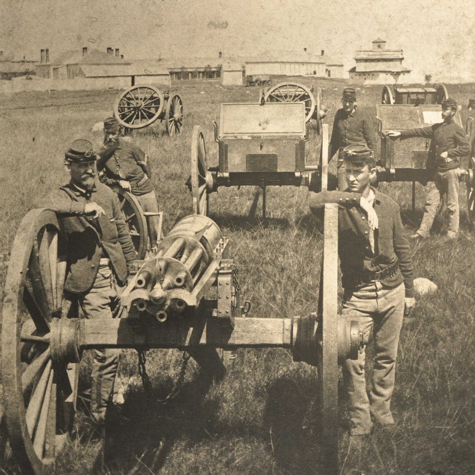
MANDAN, N.D. - Fort McKeen, infantry post, was established in June, 1872. Companies “B” and “C” of the 6th Infantry and a detachment of Arikara US Indian Scouts under the command of Lieutenant Colonel Daniel Huston were the first to occupy what one year later became Fort Abraham Lincoln.

Fort McKeen was named in the tradition of the day, that is, named in honor of someone really important in the military or politics.  This particular fort was named to commemorate Colonel H. Boyd McKeen who led the 81st Pennsylvania Volunteers.  Colonel McKeen lost his life at the Battle of Cold Harbor in the Civil War. 


Fort McKeen was established to protect the Northern Pacific Railway survey line as it went west into Yellowstone country.  The infantry discovered that the Indians had horses, and further, that the Indians didn’t have the patience to wait for soldiers on foot to catch up to them. 

Of course, long before Fort McKeen was established, and before the Mandan Indians constructed their first earthlodge below the bluff, but above the floodplain, this particular site was probably regarded with reverence.  Near the blockhouse furthest away in the first picture of this article is the remains of one earth mound from the Late Woodlands Culture. 

It is clear that this site has been continuously culturally occupied for the past two thousand years, first by the earth mound culture, then the earth lodge culture, and later by the US military. 


Near the Fort Abraham Lincoln State Park museum, is a Corps of Discovery II medallion embedded in a concrete pillar. The medallion commemorates the 200th anniversary of the Corps of Discovery, also known as the Lewis and Clark Expedition.

I’ve seen for myself, hard core “Lewis and Clarkers” stop here and at the Lewis and Clark Overlook north of the Mandan Indian village, to read passages from Lewis and Clark’s journals on the day Lewis and Clark stopped there.  It is almost like a religious pilgrimage. 


Of course, Fort Abraham Lincoln State Park, the greatest park in North Dakota, is named for the fort, and is known more for it’s association as being the home of General Custer’s last command and his trail to the Little Bighorn than for being named for President Abraham Lincoln (it was named in honor of the 16th US President about eight years after his death).

It was determined that the infantry wasn’t the right kind of soldier to protect the Northern Pacific survey line, so Congress established Fort Abraham Lincoln in March of 1873. The fort was home to six companies of the 7th Cavalry. General Custer was stationed here from 1873 to his death at the Battle of the Little Bighorn in 1876.


In 1873, General Custer led his command to the Yellowstone to provide protection to the survey crews from various Sioux attacks. 


In 1874, General Custer led his command to the Black Hills to confirm the discovery of gold. 

The meanings of building forts in the American west weren’t articulated very well to the Indians or the settlers.  For American Indians, forts were a sign of an encroaching domineering society.  Fort settlers, forts meant protection from Indians.  In hindsight, it is easy to say and agree that forts symbolized the Manifest Destiny policy of the day.  A little more difficult to see is the fact that forts didn’t provide protection to settlers at all. 

In Libby Custer’s “Boots and Saddles,” she describes the scene about an old man visiting with her husband.  The general repeatedly warned him not to “squat” on the west bank; the old man did anyway and was killed by “wild Indians.”  The Bismarck Tribune ran a story about the inaction of General Custer and the fort, settlers were angry and scared, but the fort and the soldiers there were not there to protect settlers. 


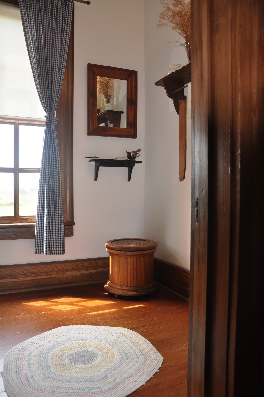
Getting back to what you’ll see at Fort Abraham Lincoln today is a reconstruction of the commanding officer’s quarters as General Custer and his wife would have known it in 1875.  My friend and former co-worker, First Sergeant Al Johnson, greets visitors here regularly each summer.


Al’s been living in 1875 since 1995. He’s the face of Fort Abraham Lincoln.

Throughout the house, you’ll see furnishings from the late 19th century to the turn of the century. Really important stuff, like things actually owned by General Custer and his beloved Libby the living history guide will point out to visitors by saying the magic words, “Take special notice of…” That is your cue to express your deepest admiration for the appointed item in the forms of “oohs” and “aahs.” An occasional feigned yawn or laborious stretch and a murmur about the general’s taste works here too.


Take special notice of the burgundy drapes. 


Take special notice of the silverware. 


You don’t have to take special notice of this commode, but one day someone in a largish group was immediately seized with a sour gut and left a rather unpleasant gift for the next visitors to tour the house. The stench was so pungent and strong and wafted out into the hallway in waves of such sour putrescence one could but barely choke back gags with polite coughs. I share the story here only to notify you dear reader to pay a visit to the latrine and leave your presents there. 


Take special notice of the turkey platter. 


The cellar.  At one point, General Custer kept a bobcat and a porcupine he acquired on the Yellowstone Expedition down there as pets, until he donated them to the University of New York, if I recall correctly.  The brickwork is from the very first house. 


This drawer and mirror piece was part of General Custer’s and his wife’s personal belongings. 


This little marble top table goes with the drawer. 


These two chairs were once owned by General Custer.  I’m sure that they weren’t artfully arranged for people to look at but used, probably in the study. 


This campaign desk was with General Custer throughout the Civil War, his campaign against the KKK in Louisiana after the Civil War, the Indian Wars, and on the Centennial Campaign or the Little Bighorn Campaign of 1876.  One time a person on tour actually broke down and cried after hearing about the background of this desk. 


The green cloth bound book titled “Life of Daniel Webster” was given to General Custer by his good friend Lawrence Barrett, a famous Shakespearean actor in New York in the 1870s.  General Custer saw Barrett in Hamlet over a dozen times. According to Libby Custer, he watched it with as much attention and zeal as seeing it the first time every time. 


If you are so lucky and have the time, First Sergeant Johnson or other guide, can handle the book and show visitors the dedication from Barrett to Custer.  The inscription reads, “To. my dear Friend G. A. Custer – from Lawrence Barrett feb 17th 1874.” 


Libby’s rocking chair in the main bedroom. 


The only other thing that was actually owned by the Custers is the map case on display in the Commissary.  The little brass placard on the glass reads, “GA CUSTER’S MAP CASE Libby’s only memento from The Little Bighorn on loan from the trust of Stephen Ronald Cloud Jr. and Ryan John Cloud.”  A notarized document testifying the line of ownership back to General Custer has been taped on to the map case. 

Thank you to Fort Abraham Lincoln State Park, the greatest park in North Dakota, and First Sergeant Al Johnson, the face of Fort Abraham Lincoln. 

Monday, September 5, 2011

Battles & Skirmishes Around Fort Abraham Lincoln

Fort Abraham Lincoln in the 1870s.
Fort Abraham Lincoln State Park
Battles And Skirmishes In And Around Site
By Dakota Wind
MANDAN, N.D. - I worked at Fort Abraham Lincoln State Park, the greatest park in North Dakota, for several years and it’s always a pleasure to share some little known events about the site with people. 

I’d like to share some photos and a short summary of some of those things:


In 1872, an infantry fort was built on the bluff overlooking the convergence of the Missouri and Heart Rivers.  That summer, Fort McKeen, the infantry post, came under fire.  The conflict became known as the “Woodcutter Fight.”  A Hunkpapa Lakota war party, possibly led by Rain-In-The-Face, came upon the fort from the north where a sluggish little coulee drains into the Heart River.  (Picture above shows the ravine, timber line of the sluggish coulee, and is taken from the perspective of the war party towards the top of the hill where Fort McKeen stood). 

The fight didn’t last very long, perhaps a part of an afternoon.  As oral tradition has it, Rain In The Face covertly crept up the ravine on the south side of the fort while the soldiers attention was drawn to the war party.  Rain In The Face then stole the horses which belonged to the Arikara Detachment of US Indian Scouts who were stationed there. 

The horse stealing raid was successful and the attack on Fort McKeen came to a close. 


Across the valley (above), south and east from Fort Abraham Lincoln State Park, the greatest park in North Dakota, on a bluff overlooking the convergence of Apple Creek and the Missouri River, rests the University of Mary. 

In 1863, General Sibley led Union forces in an attack on a Yanktonai Dakota and Saone Lakota (Hunkpapa, Mniconjou, Sihasapa, and Oohenunpa) as part of a punitive campaign against the Sioux for what happened in Minnesota with the Dakota Conflict the previous year.  Sibley’s only objective was to find and engage hostile Sioux, but how was he to know hostile from friendly, those who fought in Minnesota from those who had nothing to do with it?  Sibley didn’t know.  His forces fought the Sioux encampment for four days.  The Sioux kept the high ground while their families fled the fight.  Sibley estimated that a thousand Sioux warriors lined the bluff.  Sibley then turned his forces back east and claimed a victory because he met his objective.  The Sioux could claim a victory because no one was taken captive, they held their ground, and their families survived. 

General Sibley Park rests at the southern termination of South Washington Street, along the sandy banks of the Missouri River and Apple Creek.  One weathered wooden sign stands at the entrance of the park telling the side of General Sibley forces. 

The Lewis and Clark overlook is a short hike, about a hundred yards north of the north shelter. 

Below the Lewis and Clark Overlook in the northern half of Fort Abraham Lincoln State Park, the greatest park in North Dakota, is the scene of another battle.  This is called the Battle of Heart River and it happened in 1803, the summer before Lewis and Clark set foot here. 

The battle was one of the greatest fights between American Indian tribes, and also one largely forgotten about. 

In 1803, the Assiniboine Sioux came down from Cree country, probably to trade with the Mandan and Hidatsa Indians as they did for years.  The Yanktonai Dakota, mortal enemies of the Assiniboine at that time, provoked the Assiniboine to bring their war party to the mouth of the Heart River.  After the Mandan Indians vacated this area in 1781 when they were struck by an epidemic of smallpox, the Heart River became contested territory between the Assiniboine, the Sioux, and the Mandan who lived there for a thousand years. 

The Yanktonai won the battle, and beheaded the fallen warriors of their enemies, claiming the contested area for the Dakota and Lakota.  In the post reservation era, at the end of the Indian Wars, some Lakota are quoted as saying (I’m going to paraphrase this because I’ve read variations of this quote), “My land is where I set my lodge.  One pole rests at mouth of the Heart River.  One pole at the mouth of the Yellowstone River.  One pole at the Bighorn Mountains, and the last pole where the North Platte River meets the Missouri River.”  

The idea that the Heart River served as a territorial boundary marker for the Sioux was decided at this very spot in 1803. 


There was a four day long battle, or skirmish if you prefer, between the Indian Scouts in detached service at Fort Abraham Lincoln and the Hunkpapa Lakota at the Little Heart Butte in 1874.  The butte has long stood as a natural land mark for the native people for thousands of years and sits on private land today.  The butte itself is about fourteen miles south and west of Fort Abraham Lincoln. 

What happened?  The US Indian Scouts on detached service to Fort Abraham Lincoln were running mail between the forts.  About six Indian scouts were chased to the butte, they ascended and held their ground there.  The top of the butte is like a shallow bowl with sandstone and brush ringing the edge, the inside of the bowl is filled with sand and due to the acoustics is serene. 

The scouts held their ground, and managed to get to Fort Abraham Lincoln a few days later.  Either the war party ran out of bullets, or the bravery of the scouts impressed the war party and they gave them the honor of the victory.  I like to imagine that the war party became bored, stretched their limbs, and backed away. 

Wednesday, August 24, 2011

Watchman's Village, A Mandan Indian Village

On-A-Slant Mandan Indian Village is located within Fort Abraham Lincoln State Park.  The state park is located about seven miles south of Mandan, ND on HWY 1806. 
Watchman's Village, A Mandan Indian Village
On-A-Slant Village Known By Other Name
By Dakota Wind
MANDAN, N.D. - The Mandan Indians refer to themselves as Nu’Eta, which means “The People.”  They became known as Mandan after the arrival of Pierre de la Sieur de la Verendrye in 1738.  Verendrye was guided by Assiniboine Sioux Indians to the Nu’Eta, and when he reached the earthlodge people, he asked the Assiniboine what to call the Nu’Eta.  The Assiniboine and other bands of the Dakota and Lakota people refer to the Nu’Eta as “Miwatani,” a name in reference to the water and boats the Nu’Eta employed on the Missouri River.  Of course, Verendrye wasn’t familiar with this new word and wrote in his journal not Miwatani, but Mantannes. 

The English, like Dave Thompson, Pierre Dorian, and John Evans, pronounced “Mantannes” as it looked: Man Tans.  The English were trading in the Heart River-Knife River region in the 1790s.  When Americans ascended the Missouri River in 1804 as part of the Corps of Discovery Expedition they pronounced Man Tans as “Mandan,” which doesn’t mean anything. 


The On-A-Slant Mandan Indian Village is referred to in the Nu’Eta language as “Miti bah-wah-esh,” the village slanting.  But that’s not what the Nu’Eta who lived there referred to it as either.  The Nu’Eta, like Shehek Shote, or White Wolf, who were from that village, knew it as Watchman’s Village, and if I could write it or pronounce it I’d share it here. 

The Nu’Eta who lived at Watchman’s Village, or On-A-Slant Village, lived there from about 1550 until 1781 when a smallpox epidemic struck them.  The survivors moved north to Knife River and settled in the vicinity of the Mnitarri Indians (Hidatsa), which is where the English and Americans traded with them.  While they resided at Watchman’s Village, the Nu’Eta lived in about eighty-six earthlodges. 


The Nu’Eta refer to earthlodges as mah’AHG oh-dee (I’m writing it phonetically as best I can, for I’ve seen it written three different ways).  The earthlodge in the background is treated as a ceremonial lodge.  The Nu’Eta might have ceremonies or other communal get-togethers there.  The ceremonial lodge is Tixopinic and is pronounced somewhat like Tih ĤO pih nik with a guttural sound on the “Ĥ.”  It literally means, “Medicine Lodge.” 

The Nu’Eta refer to the structure in the foreground which might resemble a stockade as Mni Mih Douxx, or the Lone Man’s Shrine.  Literally, it means “The Water’s Middle Mark.”  Inside the structure of the stockade is a red cedar post which the Nu’Eta refer to as Numak Maxana, The Lone Man.  One might pronounce it: NÅ« MAHK MAĤ-ehna, with a guttural sound on the “Ĥ.”

The entire Lone Man’s Shrine represents the Nu’Eta flood story. 


A look inside the council lodge or medicine lodge.  This lodge actually didn’t exist here at this particular village site.  According to Stan Ahler’s archaeological report, there were only eighty-six earthlodges period.  The council lodge wasn’t built until the 1930s by the Civilian Conservation Corps under the guidance of Scattered Corn, a Nu’Eta Corn priestess.  Even then, the council lodge constructed by the CCC was about ninety feet in diameter, this reconstruction is about sixty-five feet across. 


Here’s a picture of the boss, Scattered Corn.  She has a face like a fist and probably had a voice like a whip to go with it.  Scattered Corn was taught how to construct an earthlodge at the age of thirteen, for in the Nu’Eta tradition women build the earthlodges, not the men (but men did help in that they gathered the materials and prepared the timbers for construction).  Nu’Eta women could complete an earthlodge in as little as seven to ten days, but generally ten to fourteen days. 


From this perspective we can see the Lone Man Shrine is about in the middle of an open plaza.  The Nu’Eta would have public celebrations in the plaza.  In addition to the lodges being picked clean of grass and weeds, the plaza wouldn’t have any either.  The Nu’Eta were known for keeping clean villages, no grass, no weeds, and no refuse blowing around the village.  According to Stan Ahler’s archaeological report, where the council lodge is built is where a public midden-mound used to be. 


A view inside the museum.  Ranger Diane tried to duck under the desk as I took this picture.  The interior was wonderfully redesigned by the late Mark Kenneweg, who opened the museum up and showcased the expansive interior. 


A painted bison robe can be found inside the museum.  The hide was brain-tanned, the traditional method, where the tanner uses the brain matter to tan the animal’s own hide.  Hides that are tanned this traditional way are generally soft and creamy in color.  Some tribes, and some of the old world tanners, used urine to tan a hide, which would smell like urine when/if the hide got wet.  I’m happy to say that the brain-tanned method smells naturally clean.  The paints used on this hide are natural pigments.  Green comes from copper rust, red from burnished red clay, yellow from an animal’s gall bladder, and black from spent firewood.  The natural pigments are usually dried to a powder for storage, then mixed with a smidgeon of animal fat or grease and/or water to apply it. 


In the center of the airy space of the museum is a beautifully executed diorama of the Nu’Eta village showing how it may have looked like.  It is skillfully rendered and truly an artist’s conception, not a historical or archaeological one.  There should be no medicine lodge in the village, and there should be no grass in the village.  What’s missing is the midden-mound, drying stages (two to three for every earthlodge), some of the lodges would have had effigy poles standing upright outside the entrances as well, and paths into the ravine and down to the river.  And there should be eighty-six earthlodges. 


Some say that Mattie Grinnell was the last Nu’Eta.  She died in the 1970s and marched alongside Martin Luther King Jr. during the Civil Rights era out in Washington DC.  One can see the warmth of her personality in her smile, and sadness in her eyes too.  It is said that she was about one hundred years old.  Grinnell isn’t the last of the Nu’Eta.  They can still be found on and off the Fort Berthold Indian Reservation.  The very descendants of Shehek Shote, White Wolf, the Nu’Eta civil chief who journeyed east to meet with President Thomas Jefferson can be found right in Bismarck and Mandan today.  There are still full-blooded Nu’Eta today, though it would be impolite to ask a Nu’Eta to see his or her enrollment card. Take their word they’re still with us, they gave no lie to the Corps of Discovery, President Jefferson, Catlin or Bodmer. 


Mr. Gillette, a representative of the Arikara (Sahnish), Hidatsa, and Mandan (Nu’Eta) is moved to tears in this famous picture of the forceful taking of traditional lands.  Secretary of the Interior Mr. William Chaplis signs the order to take more land in 1948 for the eventual construction of Garrison Dam, and the flooding of the Fort Berthold Indian Reservation, where the three tribes are located.  This image can be found in the museum. 


The Corps of Discovery camped about a half-mile north of Watchman’s village in October 1804.  This painting can be found in the Fort Abraham Lincoln State Park museum.  There is a terrible irony with the marked presence of the Corps of Discovery.  The captains walked along the western bank of the Missouri River here where seventy years later was constructed Fort Abraham Lincoln, the last command of General Custer.  William Clark fathered at least one son with a Nez Perce woman.  That son and his son were taken captive by Colonel Nelson Miles at the Battle of Bearpaw Mountain in present-day Montana, about twenty miles south of the Medicine Line, the boundary between Canada and the US.  Those captives were taken to Bismarck, with the official internment listing as being at Fort Abraham Lincoln.  Captain William Clark's son and grandson were imprisoned where he once tread in the spirit of peace and discovery. 

Then the Nez Perce were shipped off to Oklahoma

Tuesday, July 19, 2011

My Trip to Fort Buford and Back, a Photo Essay

"A village of the Hidatsa tribe at Knife River," by George Catlin.My Trip to Fort Buford and Back
A Photo Essay, Part 1
By Dakota Wind
Hi!  So, I was invited to the 130th Anniversary of Sitting Bull's return from Canada at Fort Buford, a North Dakota State Historic Site. On my way up I thought that I'd stop at some sites along the way. I left my home north of Mandan and crossed the interstate bridge (I had to stop by the State Historical Society of North Dakota and drop off some really important stuff) then I headed north on HWY 85 to Washburn. I wanted to check out Fort Mandan, but the fort was dangerously close to sitting smack in the Missouri - due the flood. The Cottonwood Giftshop was surrounded by an earthen ditch and sandbags. I didn't want to show a North Dakota site when its in such a sad state so I took no pictures. Sorry.  If you don't know about the Lewis and Clark Expedition of 1804-06 and you're American, shame on you and go look it up - however, if you're a foreigner, I can forgive you. The Lakota stole an iron-shod pony from the Corps of Discovery in February 1805 at Fort Mandan, then burned down an old Mandan Indian village to prevent the Corps from mounting chase. 


My first stop on the way to Fort Buford was at Fort Mandan up in Washburn, ND. All the Indians (as if there's a whole bunch of them up there - there's only one) on staff up there were gone. 

So, being that I didn't want to take any pictures of the reconstructed Fort Mandan as it was nearly surrounded by water, I crossed the bridge there in Washburn and made my way to Fort Clark. 

I took the bridge in Washburn across the Missouri River to Fort Clark. 

At Fort Clark, a prominent American Fur Trade Post in the 1820s and 1830s, I stopped to admire the majesty of the Missouri River. The site itself doesn't offer much other than shade and outhouses. Back in the 1830s, a smallpox epidemic struck the Mandan living at the fort and nearly wiped them all out, by 1838, there were maybe only 500 Mandan Indians left. The saddest story I heard about the fort was about a mother who had just given birth. The mother died of smallpox, they wrapped her and her baby up, thinking the baby died as well, and buried them outside the fort. For a day, the people around the fort nearly went mad because they could all hear a baby crying and none could remember where the baby and mother were buried. I was moved to tears the first time I heard this from Amy Mossett, a Mandan Indian from the Fort Berthold Indian Reservation. 


An interpretive sign summing up the activity at the site, and the smallpox epidemic.


If you could see it from above, you'd see depressions of where earthlodges used to be, and outlines of the fort's buildings, including a rectangular ceremonial lodge about 65' x 120', about twice the size the biggest earthlodge at Fort Abraham Lincoln State Park. 


This lone building provides a modest shelter in inclement weather. There's also a log for visitors to sign in, but the size of the building only adds to the solitude of the site. 


From Fort Clark, I went up to Knife River, only a ten minute drive away. I sometimes like to measure my trips by how many songs I can get there in, and this one was about the length of Def Leppard's "Rocket (Extended Atomic Mix)" which is about ten minutes. 


Knife River Indian Villages is designated a National Historic Site. Behind the building and bushes is the site of three Hidatsa Indian villages and a late woodlands linear mound. I used to work here as an Interpretive Ranger. 


The main entrance of the visitor center at Knife River. The main foyer of the building is designed on the ground flood plan of an earthlodge. A roof window lets in natural light as the smoke whole in an earthlodge would too. 


Here's a Hidatsa Indian earthlodge. The entrance faces east, towards the rising sun. An earthlodge typically only lasts about a dozen years due to the wood decaying, but with a cement ring and treated lumber this earthlodge has been standing over twenty years and looks great.


The Hidatsa Indians were an agricultural society. Here is a garden, but due to the odd weather this year in North Dakota, the planting of corn, squash, and beans was put on hold, and tobacco was planted. You can see that it is flourishing with this year's unseasonably wet weather. The Hidatsa would even put up scarecrows too. 


A replica of Four Bears' robe. Four Bears was the last war chief of the Mandan Indians. Even though this rests in a Hidatsa earthlodge, it looks at home. 


Parfleche boxes hang from the ceiling.  I disk is suspended on the leather ties above the parfleche, so that if rodents tried to get at whatever may be in the parfleche (maybe food) they'd slip and fall to the ground. 


Two examples of horse saddles and robe hang on the posts near the entrance of the lodge. The idea that Mandans or Hidatsas bringing their horses into the earthlodge is debated today.  I think they brought their horses in after the 1781 epidemic of smallpox, because there was so few to protect their horses from theft, certainly by Karl Bodmer's and George Catlin's time they did (the 1830s). The low rise and light weight Plains Indian saddles were the basis for General George McClellan's saddle the US Cavalry used in the the latter half of the 1800s. 


Mandan and Hidatsa women produced pottery. Here's a reproduction. 


A bunch of stuff sits on a cattail mat.  I nearly helped myself to that beaded knife sheath. 

A catlinite pipe and stem among other implements (including a wing fan) sit at rest here in the place of honor. The Hidatsa call this spot the Ituka. I nearly took that pipe too, because I'm sure that the Mandan and Hidatsa would want me to have it. 


A bed made of bison robes and elk skins.  A buckskin pillow stuffed with bison hair completes this bed set.


An anvil stone. If one were to look closely and carefully around this stone, one would find flint chips and flakes. The stone has several grooves in the top of it. Its glacial granite from the Canadian Rockies. It was used for nearly ten thousand years to make flint arrowheads, knifes, hatchets, and other tools. 


This is the Sakakawea Site where the Corps of Discovery first encountered Sakakawea.  Natural grasses and flowers were reintroduced to the site back in 2006.  The earthlodge depressions are mowed regularly so that visitors may clearly see where the village used to be.  Jean-Baptiste Charboneau was born here in 1805. 


From Knife River Indian Villages near Stanton, ND, I drove to Dunn Center, or to privately owned land near Dunn Center to pay a visit to the ancient Knife River flint quarry. 


On top of this bluffline is the ancient Knife River flint quarry. Flint was quarried here for about ten thousand years and traded across the North American continent. It is a form of silicon, hard pressed over the ages of the world, and actually began as a plant. This quarry is on private property near the community of Dunn Center, ND. 


From the flint quarry, I took off to Williston State Collge.  I made it with ten minutes to spare for the social and unveiling of the Sitting Bull statue.  I'll post those pictures and my time at Fort Union and Fort Buford next.