Showing posts with label Rain In The Face. Show all posts

Friday, February 8, 2013

Preserving The Story Of Killdeer Mountain

An image of a soldier engaged in hand-to-hand combat with a warrior. The image is engraved upon the elevator doors on the ground floor and main floor. 
Preserving The Story Of Killdeer Mountain
Public Hearing: Energy Development At Site
By Dakota Wind
BISMARCK, N.D. – The polished hall outside the Missouri Room of the Bismarck State Capital building gradually filled with archaeologists, historians, tribal representatives and land owners from around Killdeer Mountain, all from different disciplines and walks of life, all concerned citizens of a proud state.

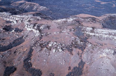
The study area of the Killdeer Mountain Conflict within the purple boundary.

The citizenry gathered in little groups here and there to introduce themselves and exchange greetings. It seemed like a fellowship of near universal concerns that brought everyone together, and life is like that. Sometimes it takes one thing to bring people together who might not have met in another situation.

An alarming amount of existing wells and proposed wells within the Killdeer Mountain Conflict area.

The hearing was scheduled at 2:00 PM CST and the fellowship exchanged the hall of polished stone and brass for the quiet cell of the Missouri River Room. A coterie of archaeologists clustered together in one corner, the tribal representatives quietly moved themselves to a corner close to the front, and historians scattered amongst the throng. Chit chat grew to a loud buzz, and though the Government and Veteran Affairs Committee was delayed an hour the motley collection of citizens didn't seem to grow impatient.

This is North Dakota, and sometimes things happen when they’re scheduled to, and other times things happen when they should. Farmers might call it natural time, Indians would agree.

Senator Triplett explains that next year marks the 150th anniversary of the Killdeer Mountain Conflict. "Its an opportunity for the state to reflect on the tragedy that shaped our statehood and include the story that has been under represented these long years," said Triplett, or something like that - my pen could not move fast enough.

The good people who made up the committee apologized for their unexpected delay and things quickly got started when Chairman Dever (Dist. 32, Bismarck) brought the gavel down with great ceremony and authority.  The hearing was to hear Senate Bill 2341, a proposal by senators on either end of the political spectrum, introduced by Sen. Wardner (Dist. 37, Dickinson) but the voice of the bill was provided by Senator Triplett (Dist. 18, Grand Forks).

Senate Bill 2341 proposed to appropriate $250,000 to do an archaeological and historical survey of the Killdeer Mountain conflict study area. A packed room of about forty-five people, including the good senators, heard testimony from several individuals representing various entities, and a few who spoke as private citizens.

Paaverud maintained an impeccable composure of respect for the committee as he endorsed the Heritage Center's support of the bill.

Mr. Merlan Paaverud and Ms. Fern Swenson represented the interests of the State Historical Society of North Dakota and voiced the SHSND’s endorsement of this bill. Ms. Swenson offered that the Killdeer Mountain study area consists of 17,433 acres or about 23 square miles, a core area of about 5,421 acres and only about 569 acres has been surveyed. Swenson also shared that the site has had a continual cultural occupation for the past 3,000 years.

Dr. Isern addresses the committee. He said his piece in about five minutes or less and gave some handouts with points explaining the nature of heritage preservation. 

Dr. Tom Isern, Director of the Institute for RegionalStudies, rendered a concise and wonderful explanation of the intrinsic value of Killdeer Mountain as a heritage site and acknowledged the attraction of the site to hikers and lovers of history and nature who would be drawn to this site, as many like-minded visitors have in the past. Dr. Isern expressed his institute’s support of the bill.

An immaculately groomed Aaron Barth (looking at the camera) visited with Mr. Jepson of Killdeer.

A few concerned citizens took to offering their support of this bill. Mr. Aaron Barth, founding writer of The Edge Of The Village, shared the need to survey and catalogue the Killdeer Mountain as a start to preserve the story of the site, if the natural integrity of the site is to be developed. “There’s a story to tell, and we must do all we can to share it,” as he compared the need to tell the stories of all combatants, like the American Civil War.

Without waver or hesitation, Young shared a resolution regarding sacred places from the National Congress of American Indians.

Ms. Waště'Wiŋ Young, Standing Rock Tribal Historic Preservation Officer, took the stand and pointedly stated that “the Indian voice has yet to be heard.” Young boldly shared with the committee a resolution adopted by the National Congress of American Indians in October of 2012 regarding the protection and preservation of sacred places. She read the whole thing, expressed her office’s support of Senate Bill 2341, and quietly departed.

Bravebull-Allard representing Standing Rock Tourism supports this bill.

Ms. LaDonna Bravebull-Allard, Director of Standing RockTourism, shared her lineage going back to survivors who were at Killdeer Mountain when General Sully forced his command on the Yanktonai Dakota, Hunkpapa Lakota and Santee Dakota. Bravebull-Allard spoke about how Killdeer Mountain was a sacred site, not just to the Dakota and Lakota people, but the Mandan, Hidatsa, Chippewa and Assiniboine. With practiced confidence of a story-teller she shared that the site was where Sun Dreamer ascended Killdeer Mountain in 1625. Bravebull-Allard’s office supports this bill.

St. John spoke with dignified authority, less than two minutes, and left many of the committee nodding their heads in approval of her gracious support.

Ms. Tamara St. John, Sisseton-Wahpeton Tribal Historic Preservation Officer, eloquently and briefly echoed Young’s and Bravebull-Allard’s sentiments of protecting a special site like Killdeer Mountain and her office’s support of the bill.

Sand called for the state to move carefully and deliberately to preserve North Dakota's heritage sites.

Mr. Rob Sand, a representative of the Killdeer MountainAlliance, a tall gentleman with the gait of a lifelong rancher took to the podium briefly and passionately encouraged oil development to wait. Sand offered the support of the Killdeer Mountain Alliance in favor of the bill.

Rothaus, self-described hard-boiled skeptic, put the bill on a scale but explained the overwhelming need to preserve as much of the story of Killdeer as possible and endorsed the bill.

Dr. Richard Rothaus, founder and director of TrefoilCultural and Natural, drove like a mad man from his office in Sauk Rapids, MN to render cold and succinct explanation of the Killdeer Mountain conflict’s standing in US military history as one of the largest, if not the single largest, Indian-White conflict in the west and why North Dakota needs to preserve as much of the conflict site and stories as possible. A former university professor, Rothaus came across brutally blunt but also exceptionally honest. He also endorsed his support of the bill.

Dvirnak proudly wore a Fighting Sioux windbreaker to the hearing. 

Lastly, Mr. Bryan Dvirnak, a lifelong rancher on family-owned and managed land at Killdeer Mountain, shared his family’s generations-long commitment to the preserving the cultural and historic integrity of the conflict site. “No one has done more to preserve and protect the site. We’re all for preserving the property,” said Dvirnak in a moving testimony to the committee. Dvirnak expressed that his brother could best articulate how their family has forged relationships with various Indian communities in state and  into Canada. The Dvirnaks have graciously allowed traditional ceremonies and prayers to be conducted on their land throughout the years.

Dvirnak, regardless of his family’s openness to the American Indian presence on his family’s land, managed to convey his open skepticism of the bill. “What will the [archaeological] study do?” he wondered aloud. Dvirnak conveyed his disillusionment with the bill, the sharpest point of his argument manifested itself in his question about what the bill would mandate him to do on his own land.

The bill doesn’t mandate anyone to do anything on their own private land. In fact, the bill mandates that the archaeologists who conduct the investigation must acquire the permissions of all landowners in the study and core areas of the Killdeer Mountain conflict. Senator Dever, the chairman of the Government and Veterans Committee, understood Mr. Dvirnak’s position and told Sen. Triplett to include language in Senate Bill 2341 that expressly and clearly articulates a mandate for archaeologists to acquire permission of landowners to survey on their land.

Mr. Dvirnak and his family have the best intentions, a family mission taken to heart, passed down from father to sons, to preserve the heritage of Killdeer Mountain. They opened their lands in the past to the Indian communities. They also donated a tidy collection of artifacts from the KilldeerMountain conflict to Dickinson State University.

They did this because there’s a story that needs to be preserved and shared, and that’s something that everyone who testified can agree. 

Wednesday, February 6, 2013

Fallen & Forgotten Veterans Of The Killdeer Mountain Conflict

A painting of the Killdeer Mountain Conflict of 1864 by Carl Boeckman.
1863 Killdeer Mountain: 150 Years Later
Fallen & Forgotten Veterans From The Past

By Aaron Barth, The Edge Of The Village
BISMARCK, N.D. - Tomorrow, Thursday, February 7, 2013, at 1400 hours (CST), North Dakota Senator Connie Triplett (District 18, Grand Forks)will collaboratively sponsor SB 2341, a bill that seeks to carry out an archaeological and historic-archaeological study on the Killdeer Mountains in Dunn County, western North Dakota. I’ll be attending this hearing (it will take place before the Senate Government & Veteran’s Affairs Committee in the Missouri River Room), and Triplett has circulated an e-mail asking historians, landowners, archaeologists, Natives and others for testimonies to support this bill. The Killdeer Mountains figure into our nation’s history and the US-Dakota Wars that spanned from 1862 in the Minnesota River Valley, and carried on through 1864 at Killdeer Mountains in western North Dakota.

Sitting Bull, great Hunkpapa Lakota leader, was present at Killdeer Mountain when General Sully decided to attack. The Hunkpapa had nothing to do with the Minnesota Dakota Conflict of 1862. Sitting Bull was among the leaders who took the Lakota west into Elk River country (Little Missouri today) in an attempt to escape an unwarrented attack. He never forgave the Union for the needless death of innocent women and children.

What we know right now about Killdeer from 1864 is limited (the State Historical Society of North Dakota has a nice and thoughtful write up of it here), and further archaeological and historical research is needed. It was an action between the Union Army and various Dakota nations, and some key players involved were Sitting Bull, Inkpaduta, Gall (among others), and General Alfred Sully and his Union soldiers. In many ways, just as this nation recognizes and respects fallen Union and Confederate combatants and non-combatants, this nation owes it to honor the Dakota soldiers and non-combatants killed in Dakota Territory during the Civil War. To extend this honor requires and necessitates a deliberate and culturally sensitive systematic archaeological and historical study like the one proposed in SB 2341. We understandably honor Americans that have fought and died in 21st century warfare, and we ought to also be honoring and rescuing those fallen and forgotten from the Killdeer Mountains from July 1864.

Pizi, or Chief Gall, led the Dakota and Lakota in a running battle from General Sibley at the conflicts of Dead Buffalo Lake, Stoney Lake and the Conflict at Apple Creek in 1863. Gall was present at the Killdeer Mountain Conflict and assisted the Lakota in a run west to Elk River (Little Missouri River) to escape Sully's advances.

Note: according to Sioux County Veterans Service Officer Roster, today in 2013 Standing Rock has a veteran population of 357.

Note: It is estimated that perhaps 150 Dakota and Lakota lost their lives at the Killdeer Mountain Conflict. The Dakota and Lakota would say, "Wokiksuya lo," "Remember This."

Friday, January 25, 2013

The Sanctuary of Killdeer Mountain

The Killdeer Mountains
Living History And Sacredness
By Aaron Barth, The Edge of The Village
KILLDEER, N.D. - The Killdeer Mountains in Dunn County, western North Dakota have been getting a lot of attention lately, especially after theNorth Dakota Industrial Commission decided to, well, industrialize the area, and allow the Hess Corporation to follow through with signed leases and drill and frack for oil there. The Grand Forks Herald reported on it here, and The Bismarck Tribune here. The Industrial Commission is composed of three individuals, including Jack Dalrymple, Wayne Stenehjem, and Doug Goehring. They have scheduled meetings with the Department of Mineral Resources and Lynn Helms, the sitting Director. It is important to remember that this was a public hearing, and at public hearings the public ought not to be shy about attending. This experiment America has going, our Democratic-Republic, necessitates these local meetings that have global implications.

On January 24, 2013, at 1:00pm (CST) the public hearing for the Killdeer Mountains was held in the capitol of Bismarck, North Dakota. It was Industrial Commission Case Number 18618 concerning sections 25 & 36, T. 146 N., R. 97 W, this about 30-35 miles north of Dickinson, North Dakota. Originally the hearing was scheduled in the Governor’s meeting room, a rather closed-off and secluded place. Because of the public turn-out, though, the hearing was relocated to the larger Brynhild Haugland room in the western wing of the capitol. I drove over from Fargo to Bismarck to attend the meeting, and while there scribbled down some notes and took some audio-video as well. The high-points, I thought, were in capturing two Native voices from two disparate cultures.

The first is a video from Theodora Birdbear of Mandaree, North Dakota (Mandaree is Mandan, Hidatsa and Arikara territory). The microphone on my Canon PowerShot SX260 HS captured the audio a bit, and just in case there are those of us hard-of-hearing, I provided transcript of Theodora’s testimony below.

Theodora Bird Bear explains the spiritual significance of Killdeer Mountains.

Transcript:
…and he expressed the impact of oil and gas development, the industrialization of an area, which impacts the quality of that spiritual experience. I guess it’s kind of equivalent to having an oil well right beside your Catholic church or something. It’s parallel to that. So I wanted the commission to know that Fort Berthold does have a living connection to that area, and to consider that in your decision making. As people have said prior to this, technology is evolving, and to keep it [oil] in the ground is not wasting it. They are going to be after it in the future. What’s the rush? The rush is quick decisions, unplanned decisions, and unplanned impacts. So I just wanted to make a comment about our relationship with that area. It is still living today.

Theodora remarks on how the Killdeer Mountains are a sanctuary, as sacred and sacrosanct as a Catholic Church, and to carry the analogy further, as a Lutheran or protestant church, a Synagogue, a Mosque, a Buddhist monastery, a Hindu temple, a Confucian temple, and so on. These spaces are sacrosanct in the sense that when an individual goes to the area to pray, they are really interested in having it as quiet. A library could also be considered a sacred space by this definition (libraries carry on that monastic-academic tradition of the deliberate contemplation of texts — this is arguably the antithesis of our hyper-industrial, full-throttle, 21st century world).

The hearing about opening up Killdeer Mountain for oil drilling was open to the general public. The Industrial Commission graciously opened the hearing to listen to concerns from the general public.

I explained that the Killdeer conflict was far larger than the delineated core, the designated North Dakota State Historical Site and involved a running battle from Killdeer Mountain west to the Little Missouri River.

There is estimated to be about 3 to 3.5 million barrels of oil under Killdeer Mountain, worth about $250 million. By not developing and extracting that mineral and oil deposit it is defined by the state of North Dakota as waste.

You, reader, can read about the Industrial Commission's decision to allow Hess Oil to drill within three miles of Medicine Hole and the Killdeer conflict site, at the Bismarck Tribune.

Monday, January 7, 2013

Taĥċa Wakutėpi: Where They Killed Deer

A golden eagle at sunset at the place where they killed deer.
Taȟčá Wakútepi: Where They Killed Deer
Sacred Site Also Historical

By Dakota Wind
KILLDEER, N.D. – Killdeer Mountain is hardly a mountain, but it is a beautiful and majestic plateau nonetheless as it rises gently above the steppe of the Northern Great Plains. In the summer, native plants and flowers dot the hillside and grow in the cracks of shattered sandstone. Short and middle indigenous grasses sway in a wind that has been present since creation.

The song of coyotes hauntingly fills the air on a gentle midsummer’s eve. The trees, a mix of ash and cottonwood grow in clusters, but it’s the cottonwood trees which sway and shush the world. Crickets take up their hum in the twilight where the cicadas left off theirs in sunlight.

Aeries of golden eagles and hawks remind the meadowlarks and rabbits to keep a wary eye on the skies. One golden eagle circles lazily above me and I take it as a good sign, my prayers will be carried, and I pause a moment to remember my grandparents.

The sunset, from the plateau of Killdeer Mountain. At the bottom of this image is the entrance to Medicine Hole. The wind exhaling the cave created a faint whistle.

At the very top of the plateau is a cave, an entrance into the heart of grandmother earth. Medicine Hole. Since the days of warriors and legend the Nu’Eta (Mandan) have called the mountain Bah-eesh, the Mountain That Sings. By day, like a great inhalation, the wind rushes into the deep embrace of the earth and at night like a long sigh the wind comes out with a whistle, and if one listens carefully, the song of the earth.

The breathing earth. The singing earth. To the Lakota what has breath has spirit, and the earth is a living breathing being, a grandmother. It is a reminder that we human beings belong to the earth. The earth doesn’t belong to people. In the Lakota language, Lahkol’iya, the earth is called Makoċė, grandmother. And she is honored as such.

"We estimated the natural gas flame had at least a 30' vertical from where it exited the stack," said Aaron Barth, Great Plains historian and archaeologist. Photo courtesy of Aaron Barth.

At dusk, when the sun’s fire has gone below the far horizon, true night no longer arrives. The moon no longer spreads her ebon robe over the land, and her embrace becomes a memory. In the distance are oil rigs. One can literally hear the fires of industry and human ingenuity humming across the land. The unnatural firelight smothers the land in perpetual gloomy twilight.

The site known today as the Killdeer Battlefield near Killdeer, ND, is known primarily for the conflict which occurred on June 28, 1864. On that day, General Sully led a command of 4000 soldiers in the last days of his Punitive Sioux Campaign in retaliation for the Minnesota Dakota Conflict of 1862. The village of Lakota and Dakota which Sully attacked had little to nothing to do with the 1862 conflict. The Teton and Yanktonai who were present had actually fought under Colonel Leavenworth’s command in the Arikara War of 1823.

General Sully’s assault continued into the evening and night with a hail of cannon volley.

The attack on the Lakota and Dakota camp from Sully's perspective.

Killdeer is designated a North Dakota State Historical Site and is valued for its contribution to the story of the state. The signage on site reflects the value the state has placed on the conflict. While there is nothing wrong with valuing, protecting, and interpreting the site as a battlefield, the story of the site as a hunting place, the story of the site as a spiritual place goes largely untold, and maybe that’s how it should be. But these are different days and the site should be preserved for more than the tragedy that occurred there.

The site was maintained by the North Dakota Department of Parks and Recreation at one time and shows it. Like Whitestone Hill, old picnic tables and a weathered playground await visitors. It’s an odd sight and it’s something that wouldn’t be seen at places like Gettysburg. A visit to a battlefield should be for reflection, not recreation.

Killdeer, or Taĥċa Wakutėpi, was more than just a place where they killed deer. Young Lakota and Dakota men would ascend the hill for prayer and reflection in the ceremony called Haŋblėċiyė, Crying For A Vision. They would mentally, emotionally, physically and spiritually prepare far in advance for their spiritual pilgrimage. The site for their quest also determined long in advance. Their quests generally lasted four days on the hill or mountain, standing, kneeling or sitting while they prayed through cold rain, blistering heat, and desperate thirst to humble themselves before the creator. Killdeer was and still is a special place for prayer and reflection.

For the Lakota, ceremonies began a long time ago. “Ceremonies are forever,” says Cedric Goodhouse, an Uncapa Lakota on the Standing Rock Sioux Indian Reservation, “We live a life, and all the negative statistics associated with that, are the direct result of having a void of our spirituality, being denied a right to practice where and when our ceremonies are done, appropriately.”


The Nu’Eta (Mandan Indians) have the tradition that the bison entered into the world from Medicine Hole.

They also have the tradition that the mountain was once solid and unbroken stone until the son of Foolish One was killed. The spirits who were present at the death of Foolish One’s son entered the mountain. When Foolish One took up the lifeless body of his son, he smote the mountain with his staff and clove it in two leaving the two parts broken and cracked as we know it today.

Medicine Hole is where some of the Lakota and Dakota people fled into when Sulley began his unwarranted assault. The story goes that some of the people wound their way through the labyrinth and came out west of the mountain. It’s possible. A landslide, however, now marks the western exit.

The entrance to Medicine Hole. 

Medicine Hole splits into three passages. In 1973, a spelunker named Earle Dodge, determined that one passage went west for about 120 feet, another was too narrow for exploration, and a third went east about 120 feet. Another spelunker made a descent of eighty feet before extreme cold made the exploration difficult to continue.

The following day after Sully’s assault, his command destroyed all that was left behind, even the dogs, of which over 3000 were put to sleep. Children who were left behind in the hastily abandoned camp were killed.

Sully executed total war theory. Up to the Battle of Antietam, the Confederate States of America were winning the Civil War. The Union needed to win and subscribed to the total war theory of treating the civilians of the enemy as enemies. This meant the capture and imprisonment of innocent women and children, if they weren’t killed outright on the battlefield.


The success of the Union in the Civil War is directly related to the success of total war theory as demonstrated in the Punitive Campaigns of 1863 and 1864. If the site should be protected and preserved for its tragic history, then it must be argued that Killdeer holds a key to the victory of the union and must be protected.

In the summer of 1998, Isaac Dog Eagle officiated the Releasing Of The Souls ceremony at the Killdeer conflict site. The following year, he conducted the Wiping Of Tears ceremony to facilitate the healing process of people who lost family in the conflict.

Several private landowners and ranchers in and around Killdeer Mountain, many of them non-native but who have fostered a relationship with the land and want to preserve the site for its natural history, are gathering together to protect the site. A group of interested individuals are coordinating efforts to enlighten oil industry officials, and hopefully preserve the integrity of a natural site worth saving for its aesthetics as it is for the cultural traditions surrounding it.

There will be a public hearing about the preservation of Killdeer Mountain at 1:00 PM on Thursday, January 17, 2013 (or January 24, 2013) with the North Dakota Industrial Commission in the Governor’s Conference Room at the State Capital. Visit http://www.nd.gov/ndic/ or call (701) 328-3722 to inquire about the correct time and date.

Thursday, October 20, 2011

One Day My Sense of Place Changed

A view of the On-A-Slant Mandan Indian Village overlooking the Missouri River.
One Day My Sense Of Place Changed
A Look At A Major Historical Site
By Dakota Wind
MANDAN, N.D. - When I was growing up on the Standing Rock Sioux Indian Reservation I heard many of the negative typical commentary about General Custer.  I’d see t-shirts at the pow-wow stands of Yellow Hair with an arrow through this hat, with words like “Custer was Siouxed,” or variants of the theme of giving Custer an arrow shirt.  T-shirts like that can still be found on the pow-wow circuit throughout Indian Country, and whenever I see one, I can’t help but smirk and nod my head at the truth of it. 

Growing up in Fort Yates, there wasn’t much choice by way of food in town, either at the grocery store or in the commodity box.  Often enough, my grandparents and many people would drive to Bismarck or Mobridge to buy groceries for the week.  When we’d drive to Bismarck, we use to have to drive through Fort Abraham Lincoln State Park.  That’s back when ND HWY 1806 went through the park. 

When I was elementary school, I remember visiting the park twice, once in fourth grade and again in middle school.  This was before the reconstructed Custer House and other buildings that followed.  The only things I recall as as a little boy were the earthlodges of the On-A-Slant Mandan Indian village.  I recall how immense the earthlodges were and how they smelled like an old cellar.  There was no guide to tell us anything more about the history, archaeology, or culture of the park.  There was no ranger to monitor or secure the earthlodges or the blockhouses.  My earliest impression of the site wasn’t just the earthlodges’ size but the smell.  People, the general public, used them as restrooms.

When I was in high school, the Custer House, Granary, Commissary, and Central Barracks were being constructed.  I’d sit in the backseat and look out the window, sometimes I’d have my headphones on and I’d almost always be listening to Def Leppard, but when my grandparents were speaking, I’d be listening to them.  When we’d drive through the park, sometimes my grandmother would tell me about General Custer and how he’d taken an Indian woman, a Cheyenne maiden, how the soldiers took Indian women and had their way with them.  Sometimes my grandmother would even talk about her great-grandfather, one of Custer’s own men.  My grandfather never spoke of Custer or mentioned the soldiers, but I could tell by the set of his hands on the steering wheel as he gripped it, it provoked him. 

In high school, I joined the basketball team and sometimes we’d drive through Fort Abraham Lincoln State Park on the way to or from a game.   The coach was also an assistant in the school’s “Indian Club.”  He definitely had an opinion about the fort reconstructions and openly shared it with the team.  I felt ashamed that one of the soldiers was my ancestor and I heard a lot of things about the character of General Custer. 

One fall day, the history teacher, a burned-out recovering hippie of a woman with weary eyes and a tired cracked monotone voice to match (we called her “Beanie”) took the class on a tour of the reconstructed Custer House.  We were guided by a man portraying one of the General’s strikers.  He told us all about the virtues of General Custer, but we had our own opinion – at least I did – and I we quietly stepped through the house.  It was one-sided and uninviting.  Nothing the reenactor could say or do could make me or the class interested because what he said didn’t affect in any way our established opinion of General Custer. 

In 1908, President Theodore Roosevelt felt a sense of place about Fort Abraham Lincoln and General Custer, and he did something about it.  He signed the Fort Abraham Lincoln Act, deeding the old Fort Abraham Lincoln to the State Historical Society of North Dakota.  What’s Roosevelt’s connection? 

In 1877, Colonel Nelson Miles led the 7th Cavalry at the Battle of Bearpaw Mountain at the end of the Nez Perce Campaign.  On Oct. 5, 1877, Chief Joseph surrendered to Colonel Miles.  Miles was ordered to bring the Nez Perce to Fort Abraham Lincoln for internment, which he did and when he delivered the Nez Perce to Bismarck, ND, he took the first train to St. Paul, MN, to meet with Gen. Terry.  The colonel was promoted to Brigadier General. 

Brig. Gen. Miles went on to capture Geronimo and was promoted to Major.  Maj. Gen. Miles had a bit part to play in the events that led to Sitting Bull’s death.  Miles believed that the Lakota should have been firmly under control of the US Military not the agents of the Bureau of Indian Affairs.  Miles personally led the invasion of Cuba in the Spanish-American War of 1898.  Colonel Theodore Roosevelt led the 1st Volunteer Cavalry, popularly known as the Rough Riders, in the Kettle and San Juan charges. 

Aside from President Roosevelt’s contemporary relationship with Gen. Miles, Roosevelt was aware of General Custer’s association with the site, and the fact that Fort Abraham Lincoln was also a prison camp for the Nez Perce (only ten days; ten Nez Perce died during that time) and for the Grasshopper Band of the Northern Cheyenne in the winter of 1877-1878. 

President Roosevelt signed the Fort Abraham Lincoln Act to preserve and protect the history and culture of the site. 

My first experience of working at Fort Abraham Lincoln State Park visited me in the form of an elderly Mandan Indian woman.  She was dying of cancer and had asked one of her relatives, her children and grand children, to step forward to continue a native presence in the On-A-Slant Mandan Indian village.  When none came forward, she reached out and asked me.  But it isn’t as simple as that.  

She greeted me in Hidatsa in passing one day.  A few days went by, then she asked who I was (when a native elder asks that kind of question, it implies asking who I descend from, who my people are, and what my traditional name is).  Time passed and one day she called me “grandson” and asked me if I would work her ancestral village.  I said yes. 

The Mandan Indian people lived at this village, only they knew it as Watchman’s Village (it was later named the On-A-Slant Village by the Civilian Conservation Corps in the 1930s), and they lived there from about 1550 to 1781.  The Mandan Chief Four Bears’ father Good Boy called that village home.  The Mandan Chief Shehek Shote, White Wolf (called Sheheke or White Coyote by some) knew this village as his first home. 

In 1781, the Mandan were struck by an epidemic of smallpox.  They left their deceased loved ones in the lodges and abandoned the village in a move north to Knife River.  They never forgot where they came from.  There are still people at rest in the On-A-Slant Mandan Indian village. 

The Mandan, the Nu’Eta, have a sense of place about Fort Abraham Lincoln State Park.  Its home and its sacred. 

I had to learn more about Fort Abraham Lincoln State Park if I was going to work there, to make it matter to me, to establish my own sense of place. 

For the Lakota, there is the phrase, “My home is where I set my lodge.  One pole rests at the mouth of the Heart River…”  In 1803, the Hunkpapa Lakota and the Yanktonai Dakota engaged the Assiniboine and Mandan for control of this contested area and won in the Battle of Heart River.  For the Lakota, one pole of the lodge of the Teton lies in Fort Abraham Lincoln State Park.  For the Lakota, despite the connection the site holds with General Custer, Fort Abraham Lincoln State Park is home. 

For the Hunkpapa Lakota, there was a skirmish within the boundaries of Fort Abraham Lincoln State Park, a “Wood Cutter Fight.”  For the Lakota, battlefields are respected and honored because that’s where people died defending their way of life, their territory, even if they were the enemy.  For the Lakota, Fort Abraham Lincoln State Park is a memorial. 

In the fall of 1874, Lieutenant Tom Custer captured the Lakota war chief Rain-In-The-Face and imprisoned him in the Fort Lincoln guard house.  Two years before his arrest, Rain-In-The-Face conducted a successful horse-stealing raid on the Arikara at the Infantry Post.  He was arrested for killing surveyors on the Yellowstone Expedition of 1873.  Rain-In-The-Face might have been arrested and detained at Fort Abraham Lincoln but he was released in the dead of night in the late winter of 1874-75.  Rain-In-The-Face never spoke a word against Fort Abraham Lincoln and the only animosity he held was for Lieutenant Tom Custer. 

In May of 1875, General Custer hosted a ten-day celebration at Fort Abraham Lincoln in honor of the peace treaty he witnessed between the Arikara, Hidatsa, Mandan, Dakota and Lakota Indians.  At that very same celebration, General Custer heard testimony of the Indians about the mistreatment they were dealt at the hands of the Bureau of Indian Affairs Agents, and carefully recorded it.  In the fall of 1875, General Custer travelled east where in the spring of 1876, he testified to Congress on behalf of the American Indians and their plight, testified against President Grant and against the Secretary of the BIA.  He was arrested.  General Terry pressured President Grant to release him.  General Terry ordered General Custer to “use any means necessary” on the Centennial Campaign, the Little Bighorn campaign. 

The Lakota of the nineteenth century might not have liked the ideology of Manifest Destiny that gripped the United States, nor the fact that General Custer led his men in the field after he hosted them at his fort, but its history, and the Lakota respect what happened.  Sitting Bull himself offered that he would not speak ill against the dead, the enemy, out of respect. 

When I began my first summer at Fort Abraham Lincoln, it was with mixed feelings.  I’ve since learned all that I’ve written above, reader, and more.  My sense of place changed. 

I believe that history should be preserved, protected, promoted even, and I believe that it must and should be shared.  The history of Fort Abraham Lincoln State Park is a story about Indians, Indians fighting Indians, Indians fighting soldiers, a story about Dakota Territory, its what you might call an all American story. 

Reader, you may already have a sense of place about Fort Abraham Lincoln State Park or a sense of place of near you, you may not.  In the very least, I hope that I give you a moment to consider something about it.   

Monday, September 5, 2011

Battles & Skirmishes Around Fort Abraham Lincoln

Fort Abraham Lincoln in the 1870s.
Fort Abraham Lincoln State Park
Battles And Skirmishes In And Around Site
By Dakota Wind
MANDAN, N.D. - I worked at Fort Abraham Lincoln State Park, the greatest park in North Dakota, for several years and it’s always a pleasure to share some little known events about the site with people. 

I’d like to share some photos and a short summary of some of those things:


In 1872, an infantry fort was built on the bluff overlooking the convergence of the Missouri and Heart Rivers.  That summer, Fort McKeen, the infantry post, came under fire.  The conflict became known as the “Woodcutter Fight.”  A Hunkpapa Lakota war party, possibly led by Rain-In-The-Face, came upon the fort from the north where a sluggish little coulee drains into the Heart River.  (Picture above shows the ravine, timber line of the sluggish coulee, and is taken from the perspective of the war party towards the top of the hill where Fort McKeen stood). 

The fight didn’t last very long, perhaps a part of an afternoon.  As oral tradition has it, Rain In The Face covertly crept up the ravine on the south side of the fort while the soldiers attention was drawn to the war party.  Rain In The Face then stole the horses which belonged to the Arikara Detachment of US Indian Scouts who were stationed there. 

The horse stealing raid was successful and the attack on Fort McKeen came to a close. 


Across the valley (above), south and east from Fort Abraham Lincoln State Park, the greatest park in North Dakota, on a bluff overlooking the convergence of Apple Creek and the Missouri River, rests the University of Mary. 

In 1863, General Sibley led Union forces in an attack on a Yanktonai Dakota and Saone Lakota (Hunkpapa, Mniconjou, Sihasapa, and Oohenunpa) as part of a punitive campaign against the Sioux for what happened in Minnesota with the Dakota Conflict the previous year.  Sibley’s only objective was to find and engage hostile Sioux, but how was he to know hostile from friendly, those who fought in Minnesota from those who had nothing to do with it?  Sibley didn’t know.  His forces fought the Sioux encampment for four days.  The Sioux kept the high ground while their families fled the fight.  Sibley estimated that a thousand Sioux warriors lined the bluff.  Sibley then turned his forces back east and claimed a victory because he met his objective.  The Sioux could claim a victory because no one was taken captive, they held their ground, and their families survived. 

General Sibley Park rests at the southern termination of South Washington Street, along the sandy banks of the Missouri River and Apple Creek.  One weathered wooden sign stands at the entrance of the park telling the side of General Sibley forces. 

The Lewis and Clark overlook is a short hike, about a hundred yards north of the north shelter. 

Below the Lewis and Clark Overlook in the northern half of Fort Abraham Lincoln State Park, the greatest park in North Dakota, is the scene of another battle.  This is called the Battle of Heart River and it happened in 1803, the summer before Lewis and Clark set foot here. 

The battle was one of the greatest fights between American Indian tribes, and also one largely forgotten about. 

In 1803, the Assiniboine Sioux came down from Cree country, probably to trade with the Mandan and Hidatsa Indians as they did for years.  The Yanktonai Dakota, mortal enemies of the Assiniboine at that time, provoked the Assiniboine to bring their war party to the mouth of the Heart River.  After the Mandan Indians vacated this area in 1781 when they were struck by an epidemic of smallpox, the Heart River became contested territory between the Assiniboine, the Sioux, and the Mandan who lived there for a thousand years. 

The Yanktonai won the battle, and beheaded the fallen warriors of their enemies, claiming the contested area for the Dakota and Lakota.  In the post reservation era, at the end of the Indian Wars, some Lakota are quoted as saying (I’m going to paraphrase this because I’ve read variations of this quote), “My land is where I set my lodge.  One pole rests at mouth of the Heart River.  One pole at the mouth of the Yellowstone River.  One pole at the Bighorn Mountains, and the last pole where the North Platte River meets the Missouri River.”  

The idea that the Heart River served as a territorial boundary marker for the Sioux was decided at this very spot in 1803. 


There was a four day long battle, or skirmish if you prefer, between the Indian Scouts in detached service at Fort Abraham Lincoln and the Hunkpapa Lakota at the Little Heart Butte in 1874.  The butte has long stood as a natural land mark for the native people for thousands of years and sits on private land today.  The butte itself is about fourteen miles south and west of Fort Abraham Lincoln. 

What happened?  The US Indian Scouts on detached service to Fort Abraham Lincoln were running mail between the forts.  About six Indian scouts were chased to the butte, they ascended and held their ground there.  The top of the butte is like a shallow bowl with sandstone and brush ringing the edge, the inside of the bowl is filled with sand and due to the acoustics is serene. 

The scouts held their ground, and managed to get to Fort Abraham Lincoln a few days later.  Either the war party ran out of bullets, or the bravery of the scouts impressed the war party and they gave them the honor of the victory.  I like to imagine that the war party became bored, stretched their limbs, and backed away. 

Friday, June 17, 2011

Battle on the Yellowstone: The Yellowstone Campaign of 1863

Custer's Last Stand. The General can be easily seen in the center lower half of this popular image of the Battle of the Little Bighorn. 
Battle On The Yellowstone
The Yellowstone Campaign Of 1863
By Dakota Wind
YELLOWSTONE RIVER, M.T. - A month after the Battle of the Little Bighorn, Galaxy published General Custer’s account of his first altercation with the Lakota on the Yellowstone three years previous. General Custer wrote under the alias Nomad for the Galaxy, what we’d call today a magazine or periodical. Here is an excerpt of that account.

There were three Yellowstone Expeditions altogether, or rather, one survey over three years from 1871 to 1873.
At ten o’clock we reached the crest of the high line of bluffs bordering the Yellowstone valley, from which we obtained a fine view of the river and valley extended above and beyond us as far as the eye could reach. Here and there the channel of the river was dotted with beautiful islands covered with verdure and shaded by groves of stately forest trees, while along the banks on either side could be seen for miles and miles clumps of trees varying in size from the familiar cottonwood to the wavering osier, and covering a space in some instances no larger than a gentleman’s garden, in others embracing thousands of acres.
A photo from the bluffs overlooking the Yellowstone River valley.

After halting upon the crest of the bluffs long enough to take in the pleasure of the scene and admire the beautiful valley spread out like an exquisite carpet at our feet, we descended to the valley an directed our horses’ heads toward a particularly attractive and inviting cluster of shade trees standing on the river bank and distant from the crest of the bluffs nearly two miles. Upon arriving at this welcome retreat, we found it all that a more distant view had pictured it. An abundance of rich, luxuriant grass offered itself to satisfy the craving appetites of our travelled steeds, while the dense foliage of the forest trees provided us with a protecting shade which exposure to the hot rays of an August sun rendered more than welcome. First allowing out thirsty horses to drink from the clear, crystal water of the Yellowstone, which ran murmuringly by in its long torturous course to the Missouri, we then picketed them out to graze.

This photo of the Yellowstone is by L A Huffman.
Precautionary and necessary measures having been attended to looking to the security of our horses, the next important and equally necessary step was to post half a dozen pickets on the open plane beyond to give timely warning in the event of the approach of hostile Indians. This being done, the remainder of our party busied themselves in arranging each for his individual comfort, disposing themselves on the grass beneath the shade of the wide-spreading branches of the cottonwoods that grew close to the river bank. Above us for nearly a mile, and for a still greater distance below, the valley was free from timber. This enabled our pickets to command a perfect view of the entire valley, at this point about two miles wide, and almost level, save where here and there is, was cut up by deep washes in the soil. Satisfied that every measure calculated to insure our safety had been taken, officers and men – save the trusty pickets – stretched their weary forms on the grassy lawn, and were soon wrapped in slumber, little reckoning that within a few rods there lay concealed more than five times their number of hostile Sioux warriors, waiting and watching for a favorable moment to pounce upon them. For myself, so obvious was I to the prospect of immediate danger, that after selecting a most inviting spot for my noonday nap, and arranging my saddle and buckskin coat in the form of a comfortable pillow, I removed my boots, untied my cravat, and opened my collar, prepared to enjoy to the fullest extent the delights of an outdoor siesta.


Tom Custer enlisted as a private during the Civil War at the age of sixteen. By war’s end he had the rank of Brevet Lieutenant Colonel and was a two-time recipient of the Medal of Honor. Though he was only a lieutenant with the 7th Cavalry on the Yellowstone Expedition of 1873, he worked to regain the regain the rank of captain by the Centennial Campaign.

I did not omit, however, to place my trusty Remington rifle within easy grasp – more from habit, it must be confessed, than from anticipation of danger. Near me, and stretched on the ground sheltered by the shade of the same tree, was my brother, the Colonel, divested of his cap, coat, and boots; while close at hand, wrapped in deep slumber, lay the other three officers, Moylan, Calhoun, and Varnum. Sleep had taken possession of us all – officers and men – excepting of course the watchful pickets into whose keeping the safety, the lives, of our little detachment was for the first time entrusted. Many of the horses even, having lunched most bountifully from the rich repast which nature had spread around and beneath them, seemed to share in the languor and drowsiness of their riders, and were to be seen here and there reposing upon the soft green carpet which to them was both food and couch. How long we slept I scarcely know – perhaps in hour, when the cry of “Indians!” “Indians!” quickly followed by the sharp ringing crack of the pickets’ carbines, aroused and brought us – officers, men, and horses – to our feet. There was neither time nor occasion for questions to be asked or answered. Catching up my rifle, and without waiting to don hat or boots, I glanced through the grove of trees to the open plain or valley beyond, and saw a small party of Indians bearing down toward us as fast as their ponies could carry them.

“Run to your horses, men! Run to your horses!” I fairly yelled as I saw that the first move of the Indians was intended to stampede our animals and leave us to be unattended afterward.

Picture adapted from a color photo taken from sixpounder’s Flickr page. The soldiers at the Yellowstone skirmish were rising from an afternoon slumber, they didn’t pitch camp as shown in the picture above.

At the same time the pickets opened fire upon our disturbers, who had already emptied their rifles at us as they advanced as if boldly intending to ride us down. As yet we could see but half a dozen warriors, but those who were familiar with Indian stratagems knew full well that so small a party of savages unsupported would not venture to disturb in open day a force the size of ours. Quicker than I could pen the description, each trooper, with rifle in hand, rushed to secure his horse, and men and horses were soon withdrawn from the open plain and concealed behind the clump of trees beneath who shade we were but a few moments before quietly sleeping. The firing of the pickets, the latter having been reinforced by a score of their comrades, checked the advance of the Indians and enabled us to saddle our horses and be prepared for whatever might be in store for us.

A staged photo by E Curtis of a Sicangu Lakota war party.
A few moments found us in our saddles and sallying forth from the timber to try conclusions with the daring intruders. We could only see half a dozen Sioux warriors galloping up and down in our front, boldly challenging us by their manner to attempt their capture or death. Of course it was an easy matter to drive them away, but as we advanced it became noticeable that they retired, and when we halted our diminished speed they did likewise. It was apparent from the first that the Indians were resorting to stratagem to accomplish that which they could not do by an open, direct attack. Taking twenty troopers with me, headed by Colonel Custer and Calhoun, and directing Moylan to keep within supporting distance with the remainder, I followed the retreating Sioux up the valley, but with no respect of overtaking them, as they were mounted upon the fleetest of ponies. Thinking to tempt them within our grasp, I being mounted on a Kentucky thoroughbred in whose speed and endurance I had confidence, directed Colonel Custer to allow me to approach the Indians accompanied by only my orderly, whose was also well mounted; at the same time to follow us cautiously at a distance of a couple of hundred yards. The wily redskins were not to be caught by any such artifice. They were perfectly willing that they orderly and myself should approach them, but at the same time they carefully watched the advance of the cavalry following me, and permitted no advantage. We had by this time almost arrived abreast of an immense tract of timber growing in the valley and extending to the water’s edge, but distant from our resting place, from which we had been so rudely aroused, about two miles.


Another staged photo by E Curtis, this one of a Oglala Lakota war party.

The route taken by the Indians, and which they evidently intended us to follow, led us past this timber, but not through it. When we had arrived almost opposite the nearest point, I signaled to the cavalry to halt, which was sooner done that the Indians also came to a halt. I then made the sign to the latter for a parley, which was done by simply riding my horse in a circle. To this the savages only responded by looking on in silence for a few moments, then turning their ponies and moving off slowly, as if to say, “Catch us if you can.” My suspicions were more than ever aroused, and I sent my orderly back to tell Colonel Custer to keep a sharp eye upon the heavy bushes on our left and scarcely three hundred yards distant from where I sat on my horse. The orderly had delivered his message, and had almost rejoined me, when judging from our halt that we intended to pursue no further, the real design and purpose of the savages was made evident. The small party in front had faced toward us and were advancing as if to attack. I could scarcely credit the evidence of my eyes, but my astonishment had only begun when turning to the wood on my left I beheld bursting from their concealment between three and four hundred Sioux warriors mounted and caparisioned with all the flaming adornments of paint and feathers which go to make up the Indian war costume. When I first obtained a glimpse of them – and a single glance was sufficient – they were dashing from the timber at full speed, yelling and whooping as only Indians can. At the same time they moved in perfect line, and as seeming good order and alignment as the best drilled cavalry.

Gall lead a war party in Yellowstone country against the survey expeditions for those particular expeditions went against the 1868 Fort Laramie Treaty. He and the war party he lead were defending their people’s territory.

To understand our relative positions the reader has only to imagine a triangle whose sides are almost equal; their length in this particular instance being from three to four hundred yards, the three angles being occupied by Colonel Custer and his detachment, the Indians and myself. Whatever advantage there was in length of sides fell to my lot, and I lost no time in availing myself of it. Wheeling my horse suddenly around, and driving the spurs into his sides, I rode as only a man rides whose life is the prize, to reach Colonel Custer and his men, not only in advance of the Indians, but before any of them could cut me off. Moylan with his reserve was still too far in the rear to render their assistance available in repelling the shock of the Indians’ first attack. Realizing the great superiority of our enemies, not only numbers, but in their ability to handle their arms and horses in a fight, and fearing they might dash through and disperse Colonel Custer’s small party of twenty men, and having once broken the formation of the latter, dispatch them in detail, I shouted to Colonel Custer at almost each bound of my horse, “Dismount your men! Dismount your men!” but the distance which separated us and the excitement of the occasion prevented him from hearing me.

Robert W. Larson put this wonderful book together about Chief Gall a few years ago. Larson made several trips to the Standing Rock Sioux Indian Reservation to visit with the descendants of Gall to learn the family oral traditions. It’s a great read, easily accessible by the everyday reader, and quick too. Go order yourself a hardcover copy, or better yet, buy it at the Little Bighorn Battlefield.

Fortunately, however, this was not the first time he had been called upon to contend against the sudden and unforeseen onslaught of savages, and although failing to hear my suggestions, he realized instantly that the safety of his little band of troopers depended upon the adoption of prompt means of defense.

Scarcely had the long line of splendidly mounted warriors rushed from their hiding place before Colonel Custer’s voice rang out sharp and clear, “Prepare to fight on foot.” This order required three out of four troopers to leap from their saddles and take their position on the ground, where by management of their horses, a more effective resistance could be opposed to the rapidly approaching warriors. The fourth trooper in each group of “fours” remained on his horse holding the reins of the horses of his three comrades.
Itomagaju, or Rain In The Face, was part of the Lakota war party on the Yellowstone in 1873. He killed a couple men of the survey crew. Tom Custer tackled Rain at Standing Rock in the fall of 1874 and imprisoned him at Fort Abraham Lincoln where he escaped from in April 1875.

Quicker than words can describe, the fifteen cavalrymen now on foot, and acting as infantry, deployed into open order, and dropping on one or both knees in the low grass, waited with loaded carbines – with finger gently pressing the trigger – the approach of the Sioux, who rode boldly down as if apparently unconscious that the small group of troopers were on their front. “Don’t fire, men, till I give the word, and when you do fire, aim low,” was the quiet injunction given his men by their commander, as he sat on his horse intently watching the advancing foe.

Swiftly over the grassy plains leaped my noble steed, each bound bearing me nearer to both friends and foes. Had the race been confined to the Indians and myself the closeness of the result would have satisfied an admirer even of the Derby. Nearer and nearer our paths approached each other, making it appear almost as if I were one of the line of warriors, as the latter bore down to accomplish the destruction of the little group of troopers in front. Swifter seem to fly our mettled steeds, the one to save, the other to destroy, until the common goal has almost been reached – a few more bounds, and friends and foes will be united – will form one contending mass.


The victory was almost within the grasp of the redskins. It seemed that but a moment more, and they would be trampling the kneeling troopers beneath the feet of their fleet-limbed ponies; when, “Now, men, let them have it!” was the signal for a well-directed volley, as fifteen cavalry carbines poured their contents into the ranks of the shrieking savages. Before the latter could recover from the surprise and confusion which followed, the carbines – thanks to the invention of breechloaders – were almost instantly loaded, and a second carefully aimed discharge went whistling on its deadly errand. Several warriors were seen to reel in their saddles, and were only saved from falling by the quickly extended arms of their fellows. Ponies were tumbled over like butchered bullocks, their riders glad to find themselves escaping with less serious injuries. The effect of the rapid firing of the troopers, and their firm, determined stand, showing that they thought neither of flight nor surrender, was to compel the savages first to slacken their speed, then to lose their daring and confidence in their ability to trample down the little group of defenders in the front. Death to many of their number stared them in the face. Besides, if the small party of troopers in front was able to oppose such plucky and destructive resistance to their attacks, what might not be expected should the main party under Moylan, now swiftly approaching to the rescue, also take part in the struggle? But more quickly then my sluggish pen has been able to record the description of the scene, the battle line of the warriors exhibited signs of faltering which soon degenerated into an absolute repulse. In a moment their attack was transformed into flight in which each seemed only anxious to secure his individual safety. A triumphant cheer from the cavalrymen as they sent a third installment of leaden messengers whistling about the ears of the fleeing redskins served to spur both pony and rider to their utmost speed. Moylan by this time had reached the ground and had united the entire force. The Indians in the mean time had plunged out of sight into the recesses of the jungle from which they had first made their attack.

The skirmish continued for more than three hours. General Custer had begun to worry about his men’s depleting ammo when the main body of troops of the Yellowstone Expedition arrived on the scene. This fight, near the Tongue River, was similar to the Wagon Box Fight on the Bozeman Trail of 1868, in that the fights were turned in favor of the soldiers because of breech loading carbines. Had the soldiers still been using muzzle loading rifles, they’d have been overwhelmed entirely in both fights.