Showing posts with label Theodore Roosevelt National Park. Show all posts

Sunday, July 23, 2017

Badlands or Pitifullands

Nakota horses survey the landscape of Charred Wood River Country (Little Missouri River Country), also known as the Badlands, at Theodore Roosevelt National Park.
The Badlands Or The Pitifullands
Place Name Of Little Missouri River Country

By Dakota Wind
Medora, N.D. (TFS) – Theodore Roosevelt National Park has been a part of the National Park Service since 1947. A site or park was in talks to honor the late president since 1921, and two units of the park were set aside to remember Roosevelt, despite a superintendent’s report findings that this park was unjustified.

The western part of the state, along the Little Missouri River is scenic. Some even say it’s majestic and open, inspiring a sense of smallness, wonder, and even isolation. The character of the landscape left a lasting impression on a president, and continues to do the same to millions of visitors today.

Roosevelt split his time between Little Missouri River country and New York from 1884 to 1887. In 1887, after a hard cold winter in which Roosevelt lost half his stock, he sold what remained so that his managers wouldn’t suffer a loss. He did not spend one continuous year in Dakota Territory.

Both units of the Theodore Roosevelt National Park reside in the North Dakota Badlands. The Badlands (one word). 


The Charred Wood River runs through the Pitiful Landscape. 

The Little Missouri River is known to the Lakȟóta as Čhaŋšótka Wakpá, or “Charred Wood.” The Lakȟóta call a landscape by the name of the water or stream that runs through it, so Little Missouri River country is called Čhaŋšótka Wakpá Makȟóčhe, or “Charred Wood River Country.”

The landscape through which the Charred Wood River runs, is known as the Badlands. The Theodore Roosevelt National Park brochure cites the Lakȟóta word Makȟóšiča, which is “Badlands.” Makȟá means “Earth.” Šíča means “Bad.” When these two words are compounded it becomes one word: Makȟóšiča. 


The visitor center proudly displays the name of the country as the Lakota know it, "Mako Shika." 

The visitor center at TRNP differs in word usage from the info it publishes. The museum showcases a panel which instead tells visitors in loud orange words “Mako Shika.” Using the new LLC standard, Mako Shika becomes Makȟóšhika.
 Makȟóšhika comes from the words Makȟá meaning “Earth,” and Úŋšika meaning “Poor,” or “Pitiful.”

Badlands or Pitifullands? 

Dakota Wind is an enrolled member of the Standing Rock Sioux Tribe. He is currently a university student working on a degree in History with a focus on American Indian and Western History. He maintains the history website The First Scout.


Tuesday, March 28, 2017

Badlands Or Bad Lands

A view of Painted Canyon at the Theodore Roosevelt National Park.
Badlands Or Bad Lands
Little Missouri Country

By Dakota Wind
Great Plains, ND (TFS) – The landscape is beautiful. Beautiful in the sense that the renaissance poet might say it was beautiful because it required a balance of placement, light, color, and time. It’s beautiful in the sense that the Lakȟóta looked at it and saw that it was inherently good, because good is beautiful. Creation is good.

Over at The Prairie Blog, author and moderator, Mr. Jim Fuglie, features a breakdown about the Badlands, or Bad Lands, if you prefer. There are readers, North Dakota citizens, and out-of-state people who are drawn to one way it's written or the other. In his article, Mr. Fuglie draws on the Lakȟóta place name for the Badlands National Park about this kind of landscape:

Why is it called the Badlands?

The Lakota people were the first to call this place “mako sica” or “land bad.” Extreme temperatures, lack of water, and the exposed rugged terrain led to this name. In the early 1900’s, French-Canadian fur trappers called it “les mauvais terres pour traverse,” or “bad lands to travel through.”

“Today, the term badlands has a more geologic definition. Badlands form when soft sedimentary rock is extensively eroded in a dry climate. The park’s typical scenery of sharp spires, gullies, and ridges is a premier example of badlands topography.”


The Lakȟóta word for land, country, or earth, is Makȟá. The Lakȟóta word for bad is ŠíčA. When the word Makȟá is compounded with ŠíčA, it becomes Makȟóšica. It would seem then, that the written proper name if one needs proper, is Badlands. ŠíčA doesn’t mean bad in the sense that the land isn’t productive, the land was/is quite good for hunting deer, elk, bison, and at one time the bighorn sheep, and might serve as a descriptor of how the landscape appeared, but the land itself wasn’t “bad.” There was something there that was malevolent and dark.


A Tyrannosaurus Rex, as featured at Dinopedia

The erosion of the landscape in the various badland formations tends to reveal fossilized dinosaur remains. The Lakȟóta refer to the great serpents as Uŋktéǧi, a twisted creation of Uŋčí Makȟá (Grandmother Earth). In the early days, after creation, they say these Uŋktéǧi ate people or caused people to mysteriously disappear. Íŋyaŋ, Stone, created WakÍŋyaŋ, the Flying Ones, to do battle with the Uŋktéǧi. WakÍŋyaŋ fly in from the west, terrible lightning flashes from their eyes, and wind gusts from each stroke of their wings, as they cleanse Makȟóčhe Wašté, the Beautiful Country (Great Plains; North America).

The Lakȟóta also name the regions of Makȟóčhe Wašté by the name of the stream which flows through it. The Little Missouri River is known to the Lakȟóta as Čhaŋšótka Wakpá, or Charred Woods River. The Badlands, by this place name method, is called Čhaŋšótka Wakpá Makȟóčhe, meaning Charred Wood River Country. They might call it this if born in that country. In everyday speech, however, the Lakȟóta would call it Makȟóšica.

Mr. Fuglie knows that it isn’t worth the energy to argue about the semantics of Badlands vs. Bad Lands (he prefers two separate words). The better question to ask, and perhaps argue over, would be, “what does the Badlands mean to you?”


Dakota Wind is an enrolled member of the Standing Rock Sioux Tribe. He is currently a university student working on a degree in History with a focus on American Indian and Western History. He maintains the history website The First Scout.

See also:
The Sheyenne River Or The Cheyenne River

How To Pronounce Oahe


Visit:

Theodore Roosevelt National Park
____________________

Glossary:


Čhaŋšótka Wakpá (chahn-SHOHT-kah wahk-PAH): Charred Woods River

Íŋyaŋ (EEN-yahn): Stone

Lakȟóta (lah-KHOH-tah): lit. “Affection.” Friend or Ally

Makȟá (mah-KHAH): Earth

Makȟóčhe Wašté (mah-KHOH-chay wash-TAY): The Beautiful Country, Great Plains, North America

Makȟóšica (mah-KHOH-shee-chah): Badlands

ŠíčA (SHEE-chah): Bad

Uŋčí (oon-CHEE): Grandmother

Uŋktéǧi (oonk-TAY-ghee): Serpents, or Dinosaurs

WakÍŋyaŋ (wah-KEEN-yah): Winged Ones, Thunder

Wakpá (wahk-PAH): River


Monday, June 17, 2013

A Visit To Elk River Country

Hehaka TaWakpa Makoche 
(Elk River Country)
AKA Theodore Roosevelt National Park

A Photo Essay by Dakota Wind
MEDORA, N.D. - Anytime I visit a place with my sons, if the Lakota people have a name and a story about it, I tell them about it as the Lakota know it. The above image was taken at the Painted Canyon Visitor Center. There, I quietly shared the story of General Sully's punitive campaign against the Lakota that started at Killdeer Mountain and led the soldiers to the Badlands, Makoche Sica.


This was taken about a mile south of Wind Canyon. My youngest son wanted to pick flowers so we walked about and found some. When we came upon some, I told him that we must never pick the first ones we see, that we want the flowers to return, so we can pick the second flower we come across.


Any trees of big size grow on the Elk River floodplain. This little shrub was growing between broken sandstones on a hillside.


There it is. Elk River. Today the river is known by its contemporary name, the Little Missouri River. It was a favored place of the Lakota, Cheyenne, Mandan and Hidatsa to hunt elk.


Here's a feral herd of horses within the park. The horses descend from horses which were removed from the Lakota in the late 1800s. My youngest son knows that the horses aren't "ours" as in ownership, but he calls them "ours," as in "our friends."


A gange of bison roam the park too. These bison are pure blooded bison from the gange at Yellowstone National Park. By the turn of 1900 there were only about 300 pure blood bison that could be accounted for there. They were close to extinction, but have made a return.


There were several colts among the haras (one of those fancy collective nouns for horses) in the park. Several other visitors had gotten out of their cars and trucks to take pictures, but we didn't. My youngest rolled down his window and called out to them. 


It was windy, but then it always is on the Great Plains. The wind has been here since creation and still blows strong. The wind blew and carried the wonderful scent of sage across the endless rolling miles. Here's a little valley of sage. Last year my youngest son picked sage for my mother here because her house smells like this.

Thursday, July 28, 2011

My Trip to Fort Buford and Back, a Photo Essay Part 2

The new Sitting Bull statue is unveiled at Williston State College.
My Trip to Fort Buford and Back
Photo Essay Part 2
By Dakota Wind
WILLISTON, N.D. - Williston State College wants to challenge and change the sense of place that the community of Williston has of it. The campus has what this writer could only describe as an industrial look to it. The architecture of the campus is heavy on brick, concrete, and pavement. Some locals have taken to calling it “Walmart.”


On July 15, 2011, Williston State College unveiled the Sitting Bull statue to commemorate the 130th anniversary of Sitting Bull’s return to the United States. Sitting Bull and the Hunkpapa, or at least the Hunkpapa who followed him, numbered about 200 at Fort Walsh across the border. Sitting Bull actually returned to Fort Buford on July 18, 1881, just over five years after the Battle of the Little Bighorn.  


Michael Westergard created the bronze Sitting Bull statue which now stands at Williston State College. At the base is the speech which Sitting Bull was said to give as he handed his gun to Crow Foot, who in turn turned it over to commanding officer of Fort Buford. The speech is also in Lakota. Did Sitting Bull Surrender? On Standing Rock, where the Hunkpapa Lakota reside, some interpret the event as an exchange of one lifestyle that of the nomadic hunter-gatherer for that of a sedentary one.


Kevin Locke performed the hoop dance and some flute playing. Locke rendered White Cloud’s “The Indian Prayer” and an American Indian version of the 23rd Psalm in Plains Indian sign and gesture. I did not take pictures of Locke demonstrating the prayers.


Ernie LaPoint, great-grandson and direct lineal descendant of Sitting Bull, offered some words to the community of Williston and all present about his famous ancestor. He is an enrolled member of the Oglala Lakota on the Pine Ridge Sioux Indian Reservation in South Dakota. LaPoint articulated his ill feelings about the people of Standing Rock to the people in attendance. I don’t know if LaPoint has ever met with the nearly 16,000 enrolled members living on and off the reservation. One can read LaPoint’s thoughts of Standing Rock by reviewing his book "Sitting Bull: His Life and Legacy."


This writer isn’t trying to cut down the works or teachings of LaPoint. Far from it. LaPoint is seemingly a good man possessed of great humor and quick wit. This writer wants you, reader, to be aware that Standing Rock has good people too and is a great place to live and visit. There might not be lineal descendants of Sitting Bull on Standing Rock, but Sitting Bull’s own band are still there, the Hunkpapa Lakota (some are also on the Fort Peck Sioux Indian Reservation).


From Williston State College this writer went to Fort Union. The above picture is the view across the river much the same as Karl Bodmer knew it back it in the 1830s.  

Picture of Fort Union from Frank Leslie’s Illustrated Newspaper, May 1868.

It was once an American Fur Trade company outpost from 1828 to 1867. The Hunkpapa Lakota attacked this fort several times in the 1860s. The fort itself was a rendezvous for several tribes like the Crow, Hidatsa, Arikara, Mandan, Chippewa, Blackfeet, and the Dakota/Lakota.


Last summer, June 2010, this writer asked the ranger on duty in this room, the reception area for trade, for my allotment, to which he said after a stunned moment, “We don’t do that anymore.” 


Mr. Loren Yellow Bird was gracious enough to take a picture with this writer outside the commanding officer’s quarters within Fort Union. The walls were intended to keep out Indians, but now an Indian serves as superintendant of the site. Mr. Yellow Bird brings understanding of cultural and historical context to this national historic site.  


Fort Union along the Upper Missouri River seen today much as it would have been seen in the mid nineteenth century. The fort is inside North Dakota but the drive and parking lot are in Montana.  


A couple of miles east of Fort Union is Fort Buford, a North Dakota state historic site. It was in operation from 1866 to 1895 when the US Army abandoned it. The fort was established as a camp in mid 1866 and was attacked almost daily until the late fall. The Lakota saw the forts along the Missouri as representative of invasion. Fort Buford is where Sitting Bull exchanged one lifestyle for another (generally regarded as a surrender) in July 1881.  


The Missouri-Yellowstone Confluence Interpretive Center. If ever you, dear reader, get a chance to visit the northwest corner of North Dakota, take in this center. A museum is inside and the trails there offer beautiful riverfront walks. The staff are friendly and offer tours of Fort Buford.  


The North Unit of the Theodore Roosevelt National Park.


Again.


Another view from the other side of the Little Missouri River valley at the North Unit.


On my way home, I stopped by the Killdeer Battle site, a North Dakota state historic site. The signage says “Tachawakute (The Place Where They Kill Deer),” and far be it from this writer to disagree with interpretive signage, and though this writer has often heard it called “Killdeer,” it might be more correct to interpret the name as The Place Where They Hunt Deer, or in Lakota “Tahċa Wakutėpi.”  


Carl Ludwig Boeckmann painted this scene of Killdeer entirely from memory. The depiction of the landscape is surprisingly accurate. Look for similarities between this image and the following pictures.  


This is the east side of the Killdeer plateau. This writer parked and hiked and climbed the east embankment and walls to reach Medicine Hole, where the Dakota and Lakota say that some of them escaped the military by crawling through the tunnels. This author arrived as the sun was setting. A lonely coyote sung in the hills somewhere, dragonflies buzzed and kept the mosquitoes to a minimum. A slight breeze caused the leaves and branches to “shush.” It would have been an entirely peaceful visit if this author wasn’t aware of the gunfight that happened here in 1863.  


Medicine Hole.


A view from Medicine Hole at the top of the Killdeer plateau to the southwest.


A view from Medicine Hole (bottom foreground) to the sunset west-north-westerly.  


A view of the Killdeer plateau from the southeast facing northwest as the sun sank behind the geophysical feature.


A hawk flew into frame as this writer caught one more picture of the Killdeer site from the southeast looking northwest.

Thursday, June 30, 2011

Photo Essay: From Little Bighorn To Fort Abercrombie

Photo Essay Of Skirmish Site & Little Bighorn Battlefield
Theodore Roosevelt National Park & Ft. Abercrombie
By Dakota Wind
GREAT PLAINS - About five miles south of Fort Abraham Lincoln State Park is the original boundary of the Fort Abraham Lincoln military reservation along a little creek which converges with the Missouri River.  In the middle distance of the picture, close to where the bush and scrub line is, is that creek. The Lakota had launched a ten day siege on Fort Rice back in 1868, a smaller less-organized war party had attempted to do the same on Fort Abraham Lincoln in 1873. The field in the picture is privately owned (see image above), but the creek is property of the US Army Corps of Engineers. There is no signage to mark the skirmish, but it is right off of HWY 1806, five miles south of Fort Abraham Lincoln State Park. 


Painted Canyon (see above) lies west of Dickinson, ND on I-90, out by Theodore Roosevelt National Park. The canyon is as old as the Grand Canyon, but not nearly as large or well known. If you ever get a chance to visit North Dakota, take in a visit to this geophysical site and experience the mystery of creation. I felt a vast serenity and immense solitude on my early morning visit here. 


Another view of Painted Canyon (above). 


About fourteen miles easterly of the Little Bighorn Battlefield is "The Crow's Nest," (above) in the distance near the center of the photo. The Crow and Arikara scouts told General Custer that there were more Indians than bullets, and they also advised him to attack immediately while they had the element of surprise. The General waited for about three hours instead, much to the disgust of the scouts. 


In roughly the center of this picture (above) is where Major Reno began his engagement with the Hunkpapa Lakota (Teton).  Major Reno was an officer used to office work, and had no experience fighting Indians. General Custer divided his command into three with himself leading one third, Major Reno leading a third to make the first attack, and Captain Benteen who lead the last third - the pack train. Reno's attack was to draw the warriors south, the women and children of the Lakota and Cheyenne fled north, General Custer was to flank the encampment from the north - where the women and children were fleeing to, but the encampment was larger than he anticipated. This actually was the same strategy that General Custer employed at Washita, in Oklahoma, where he was also outnumbered.  When he captured the women and children there, the fight ended, but it ended with the deaths, a massacre, of Cheyenne women and children. But that's a tale for another day. 


Here's the timber line (above) where the Hunkpapa Lakota, led in a counter attack by Chief Gall, retaliated and pushed back Major Reno and his command.  Chief Gall, Pizi Intancan, had stepped away from his wife and children, as he did so, they were shot by the soldiers in Reno's command.  Among the first, if not the very first of Reno's command to be killed in retaliation, was Bloody Knife.  Gall, or Pizi, and Bloody Knife, known to the Lakota as "Tamina Wewe," were lifelong adversaries who grew up in the same Hunkpapa encampment. 


The Little Bighorn River, or creek if you prefer (above). Major Reno witnessed the end of Bloody Knife in a way that probably haunted him the rest of his life. Bloody Knife rode in with Reno against the Hunkpapa Lakota and was promptly shot in the head, his brains and blood spattered onto Reno's face. Reno was so rattled that he called for his men to mount and dismount three times before their retreat. Reno's and his men's retreat took them across this part of the Little Bighorn River, and up the embankment towards where I standing when I snapped this photo. 


After Reno's retreat, the entire encampment of Lakota and Cheyenne followed General Custer's command to this site, Last Stand Hill (above). General Custer failed to capture any women and children, the encampment was far larger than he thought, and tactics dictated that he ascend the highest point of battle for any advantage, however slight. He and his entire command were killed to the man. The warriors took the hill using three tactics at once: some warriors rode around the hill and me (as seen in many movies), some rode directly through the soldiers to count coup or take them out, yet others shot their arrows up and over the circle of riding warriors and into the soldiers on the hill - according to Wooden Leg, a Northern Cheyenne, it literally rained arrows, and the dust kicked up by the horses turned day to night. 


During and after the fight at Last Stand Hill, some Lakota continued to harass Reno and his command. A Lakota sharpshooter took shelter from the top of this hill (above) and proceeded to pick off soldiers who were trying to dig a shelter and assemble a makeshift field hospital. The Lakota Akicita nearly took out a line of soldiers before being shot himself. 


Here are the Bighorn Mountains to the south and west of Little Bighorn Battlefield (above). The Lakota and Cheyenne encampment broke the day after the Battle of the Greasy Grass and moved across this plain below. To the Crow and survivors who witnessed the camp break, the movement was awe inspiring. Nothing has been seen like that since. 


Captain Weir came a day after the camp breakup and took a survey of the battlefield from this point, today called Weir Point (above). I took this picture looking south to the Reno-Benteen site. 


From the same spot, I simply turned northerly to face the Last Stand Hill (above), which I tried to center in this photo. I have a higher resolution of this image, but I couldn't post it here - too big. 


On the drive north from Weir Point to Last Stand Hill I encountered some ponies on the privately owned part of the battlefield (above). The Real Bird family on the Crow Indian Reservation put on a reenactment of the battle each year on their land on the battlefield. I've only seen parts of it, but I'm sure that some day I'll catch the whole thing. My reenactor friend, Mr. Stephen Alexander (the world's foremost Custer living historian), has invited me to participate in killing Custer (him) one day and then dying beside him the next. As a native, I'm part of a very select few who could do this. I might take him up on killing him one day, figuratively speaking of course. 


The horses are acclimated to the heavy traffic from visitors to the battlefield. I got within five feet of this recently born foal (above). The mare "whuffed" at me and stepped over to me and brought her head to my outstretched hand. 


About a hundred paces north of the 7th Cavalry monument is the American Indian monument (above). It lists the tribes and bands who fought to defend their way of life at the battle. The tribes who participated in the battle are the Lakota, Cheyenne, Arapaho, Crow, Arikara, and Blackfeet. 


Here's a close up of the metal sculpture (above), a beautiful open representation of Northern Plains Indian pictography. I learned that the Cheyenne have a different name for the battle. They refer to it as "The Battle where the girl rescued her brother." According to one an oral tradition, a boy or young man was unhorsed at the battle. The girl, or young woman, jumped onto a horse and raced into the fight to get him, and she did. 


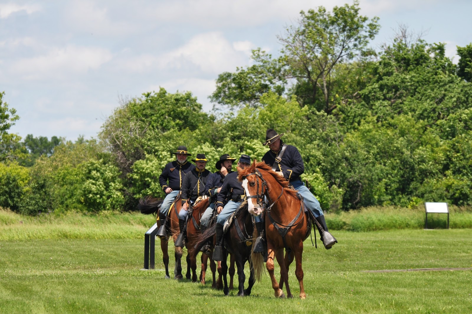
A few days later, I was at Fort Abercrombie south of Fargo, ND about twenty miles, on the day of the 135th anniversary of the Battle of the Little Bighorn (above). After the battle, Co. F of the 7th Cavalry, was brought to Fort Abercrombie. A group of reenactors of the 7th Cavalry were there. 


This group of the 7th Cavalry were conducting some drills on horseback (above).


One of the reenactors liked my presentation and my stuff, so he snapped this pic of me with my wintercount (above). I was in one of the blockhouses at the fort, Fort Abercrombie. Two of the 7th Cavalry reenactors were native, one an enrolled Cherokee and the other an enrolled Choctaw, both from Missouri. They really liked my combination of native regalia and cavalry, and invited me to participate in next year's civil war reenactment someplace in Missouri where natives fought for the Union and the Confederate States of America. I'd like to go, but I think that I'll wear the blue.


South of Mandan, ND about thirty miles on HWY 1806, is this interesting geophysical feature (above). It has at least four names I've heard, but my favorite is "Rain In The Face Butte." I took a long-time friend of mine down to Cannonball once and on our way I pointed this out on our drive. I told him that the Indians believe that this face looks up into the heavens to the face thats on Mars. I was so serious about it, and his reaction was a mix of confusion and wonder, that I waited a minute to tell him I was pulling his leg. The butte does resemble the profile of a person looking up though, and probably not to Mars.