Showing posts with label Bismarck. Show all posts

Friday, August 4, 2017

Crying Hill, An Endangered Historic Site

"Crying Hill," or "Mandan Hill" can be seen in the middle of this photo, the Missouri River down below, city development behind in the distance. 
Crying Hill Endangered
Site Overlooks River, City, Interstate
By Dakota Wind
Mandan, N.D. (TFS) – A hill rolls above the floodplain where the Heart River converges with the Missouri River. It divides the city of Mandan from traffic of I-94. It loudly proclaims “MaNDan” on its east face in bright white concrete lettering; the south face of this same plateau says the same but with trees spelling the city's name.

It’s the home of the Mandan Braves, named after the indigenous people who lived there on the banks of the Heart River as traders, fishers, and farmers. The Nu’Eta, as they call themselves, could defend themselves when called for as well. They lived in fortified villages in the Heart River area from about 1450 to about 1781.

Each village had a civil chief and a war chief to advice and look after their interests. The Nu’Eta were productive and hard-working. They must have been doing something right; their villages possessed no jails.

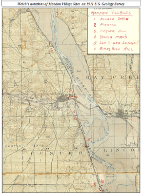
Welch's notations on a 1911 US Geological survey map. Bismarck and Mandan have grown considerably in the hundred+ years since. 

The village along the banks of the Heart River in present-day Mandan, ND was large, with a population of perhaps as many as 3000. Its identified mainly as a Nu’Eta site, but the Hidatsa claim the populace as their own. The Hidatsa became neighbors of the Nu’Eta sometime around 1600 C.E., and inter-married with them over the centuries that today one isn’t Nu’Eta without having Hidatsa relatives.

This large village was known by many names. The Nu’Eta called it Large and Scattered Village. The Hidatsa called it the Two Faced Stone Village for the sacred stone feature atop the plateau overlooking their village. Crows Heart, a principle leader of the Nu’Eta, informed Colonel Alfred Welch that that they called the village there in present-day Mandan, “The Crying Hill Village.” Crows Heart also essayed to Welch that they called it so because their women went to the top of the hill to mourn for lost relatives.

Another village there, south of the Crying Hill Village, called Motsif today, was known by the Nu’Eta as Youngman’s Village. According to Welch’s informants, the Nu’Eta of both these two villages would gather together and inhabit a winter camp in the timber on the floodplain of the Missouri River[1].

According to the late Mr. Joe Packineau, the Crow separated from the Hidatsa at the Crying Hill Village, adding that the village was also called the Tattoo Face Village, and further, that it was Hidatsa, not Nu’Eta. In the time of Good Fur Robe, he had a brother whom they called Tattoo Face. A hunt concluded with a dead bison recovered from the middle of the river. Good Fur Robe divided the kill and took the paunch, which infuriated Tattoo Face and his people, who picked up and moved west. According to Packineau, the Hidatsa called them not Crow, but “The Paunch Jealousy People.” Where the Crow broke away from their Hidatsa relatives was at the Crying Hill Village[2].

Welch drew this diagram mapping the features of Crying Hill. Visit the Welch Dakota Papers site.

At the top of Crying Hill were stone features (including a stone turtle effigy measuring twelve feet across), sacred to the Nu’Eta, upon which were images or pictographs, which changed, and were said to be able to tell the future. One oracle stone in particular, was said known as the “Two Face Stone.” When diviners gathered ‘round to interpret the stone’s musing for the future, they would lift the stone, which seemed to them to be very light. Upon putting it down, they would lift again, and the stone mysteriously weighed more than one could lift. They called this stone Two Face because of its dual nature, and according to Welch’s informant, the village below was called “Two Face Village.” Enemy Heart, an Arikara man, estimated the side of the Two Face Stone to be a diameter of about 18 inches[3], it’s location, at least in 1912, was lay just east of the Morton County Courthouse in Mandan, ND[4]. Enemy Heart insisted that the Crying Hill Village’s proper name was Two Face Village.

In the 1870’s, as the city of Mandan developed on the remains of the Large and Scattered Village, or Crying Hill Village, or Tattoo Face Village, Two Face Village, homes and streets encroached on Crying Hill itself. One day, a prospective home owner, took dynamite to the sacred stone on the hillside of Crying Hill and blew it up[5]. Welch contends that the greater oracle stone was drilled and split by white settlers for building stone. One resident, Mr. G.W. Rendon built the basement of his house from fragments of this holy stone[6].

There used to be a burial ground at Crying Hill. In 1933, laborers of the city of Mandan were expanding development of the city for two new houses, and disturbed the graves of eleven Nu’Eta men and women, including a baby. Col. Alfred Welch was called on to offer his assessment of the findings, and he estimated that the size of the Crying Hill Village at about 3000 souls, and was occupied for about 300 years[7], from ~1500 C.E. to about ~1800 C.E. The bodies were hastily buried, possibly due to the haste in which the survivors departed the Heart River villages in 1781 following the smallpox epidemic which struck them.

This reconstruction of the 1863 Apple Creek Fight is overlaid on 1850's Warren survey map. 

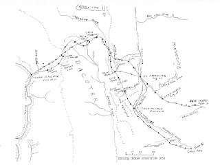
Crying Hill overlooks one of the largest conflicts in Dakota Territory history. In 1863, General Sibley led ~2200 soldiers into Dakota Territory on a punitive campaign from Camp Pope in Minnesota. The campaign concluded at the mouth of Apple Creek, on Aug. 1, 1863, when Sibley withdrew from the field of conflict, unable to pursue the Lakȟóta across the Missouri River. The Húŋkpapȟa, led by Black Eyes, crossed the Missouri River where the Northern Pacific Railroad Bridge spans the river, and thence up the Heart River to escape pursuit.

A week after the Apple Creek conflict, Black Eyes brought the Húŋkpapȟa back across the Missouri River and re-crossed the Missouri at the northern most mouth of the Heart River (which had three mouths at that time), and camped above the floodplain opposite Crying Hill. During the night, miners from Fort Benton, MT came down and camped on a sandbar. The next morning the miners tried forced themselves on a Lakȟóta woman who had gone down to the river to refresh herself. She died at the miners’ hands; Black Eyes retaliated and the Húŋkpapȟa warriors awoke and hurried to the river’s edge and exchanged gunfire with the hostiles. During the fight, the boat’s swivel gun misfired into the boat itself causing a fire to break out. The miners were killed to the last man, and there precious gold was scattered about the sandbar[8].

The Mandan Historical Society features this photo of the "Mandan Hill" in the summer of 1959. Visit the Mandan Historical Society today.

In 1934, a local Boy Scouts troop arranged forty-seven truckloads of local stone into giant letters which spelled out “MaNDan,” on what became renamed “Mandan Hill.” It was maintained by the Boy Scouts, Girl Scouts, and the Mandan Jaycees over the years, then in 1968, after Interstate 94 (I-94) was complete, the “MaNDan” sign was reconstructed in concrete. In the late 1990’s, pine trees were planted on the south face of Crying Hill arranged to spell “MANDAN[9].”

Sometime in 2003, Mr. Patrick Atkinson, acquired 4.7 acres of what remained of Crying Hill, to save it from development. Atkinson heard that the property was going to be put on the market, and he dashed up to Crying Hill after hearing a little about the lore, and provoked by his own winter memories of sledding down the face of Crying Hill. He took his son to the site to talk about what it meant to them. They concluded to save what they could. Atkinson maintains that the Crying Hill preservation effort is ecumenical and non-political, preserving the site for the sake of the sacredness and inspiration found there by native and non-native alike[10]. Visit Atkinson's site about Crying Hill.

In 2008, Preservation North Dakota declared that Crying Hill was endangered. To be declared endangered, a site must be of historical, cultural, or architectural significance and in danger of demolition, deterioration, or substantial alteration due to neglect or vandalism. Preservation North Dakota acknowledged the preservation efforts of Atkinson and the Crying Hill preservation coalition for saving Crying Hill for the edification and gratification of future citizens.

Dakota Wind is an enrolled member of the Standing Rock Sioux Tribe. He is currently a university student working on a degree in History with a focus on American Indian and Western History. He maintains the history website The First Scout.


[1] Welch, Alfred, Col. "Good Fur Blanket Was Mayor Of Mandan In 1738 - Proof Is Found Of Ancient City On Present Site." Mandan Daily Pioneer (Mandan), April 14, 1924.
[2] Welch, Alfred, Col. "Joe Packineau's Verson of The Split and Formation of Crows." Welch Dakota Papers. November 15, 2011. Accessed August 2, 2017. http://www.welchdakotapapers.com.
[3] Welch, Alfred, Col. "Arikara Hide Their Sacred Stone From The Sioux." Welch Dakota Papers. November 15, 2011. Accessed August 2, 2017. http://www.welchdakotapapers.com.
[4] Welch, Alfred, Col. "More About The Two Face Stone." Welch Dakota Papers. November 15, 2011. Accessed August 2, 2017. http://www.welchdakotapapers.com.
[5] Welch, Alfred, Col. "The Minnitari Stone." Welch Dakota Papers. November 15, 2011. Accessed August 2, 2017. http://www.welchdakotapapers.com.
[6] Welch, Alfred, Col. "Stone Idol Creek Journey." Welch Dakota Papers. November 15, 2011. Accessed August 2, 2017. http://www.welchdakotapapers.com.
[7] "Spades Of Workers Rudely Disturb Last Resting Place Of Ancient Gros Ventres Warriors." Mandan Daily Pioneer (Mandan), May 11, 1933.
[8] Dakota Wind. “The Apple Creek Fight.” The First Scout. Nov. 17, 2014. Accessed Aug. 4, 2017. http://thefirstscout.blogspot.com.
[9] "Mandan Hill 501 N Mandan Ave." Mandan Historical Society. 2006. Accessed August 2, 2017. http://mandanhistory.org.
[10] Crying Hill Heritage Site. 2003. Accessed August 3, 2017. http://www.cryinghill.com


Monday, July 31, 2017

Mandan Woman Turned Into Stone

A lichen covered red granite stone rests in the earth about halfway up the plateau at Fort Abraham Lincoln State Park. Not evident in this photo of this stone, but a rut runs through the half which is exposed to the elements.
Mandan Woman Turned Into Stone
Trees Grew To Honor Her Bravery

As told by Capt. Henry Marcotte (ret.)
Bismarck Tribune, Reprinted Dec. 15, 1922 as “The Clump of Trees on The Hogback”
Mandan, N.D. (TFS) - Fifty years after the construction of Fort McKean and Fort Abraham Lincoln, Captain Henry Marcotte (ret.), shared a story of sacrifice and remembrance regarding a Lakȟóta war party leader, a Nu’Eta (Mandan) man, and a beautiful Nu’Eta woman.

In 1872, Marcotte was serving at Fort McKeen as the Chief of Scouts. In his first summer of service he witnessed many ambuscades carried out on the north side of the newly constructed fort. Marcotte also witnessed the brave responses of the Fort McKeen Detachment of US Indian Scouts - namely, the Sahnis (Arikara). On the evening of November 3rd, Marcotte was invited to sit and smoke with the Sahnis, Hidsatsa, and Nu’Eta, and heard the tale of Black Hare, a Nu’Eta woman.

They had gathered just outside the north side of the palisades of Fort McKeen. It was the custom of Plains Indian men and women to sit on the ground in treaty, in council, at home, and in prayer. Men sat with straight backs and legs crossed; women sat with their knees together, legs tucked under and back, heels to one side. On this day, however, only men were present, and Marcotte undertook to sit on a rock that had been rolled into the circle.

At this gathering, though all spoke different first languages, Marcotte watched and listened to the men speak carefully and deliberately, testing the friendship of all gathered. Sergeant Young War Eagle began the afternoon with a pipe and passed it onto each man calling out his name, who responded in the affirmative. 


By 1910, five trees remained on the top of the plateau, where once was Fort McKeen.

When it was Marcotte’s turn, Young War Eagle recognized him as an officer, then pointed at the rock upon which Marcotte sat. Young War Eagle explained that Marcotte sat on the petrified remains of the Nu’Eta woman known to them as Black Hare. It was to recount her story that brought them together that day. Marcotte doesn’t mention whether or not he removed himself from his perch, but it would have been good manners to do so, and to apologize for his faux pas. Young War Eagle and the men gathered apparently took no offense, and the sergeant recounted the story of Black Hare, as Marcotte noted, “in pleasing tones.”

Black Hare, a young woman, was renowned by many nations near and far for her great beauty. She turned down all her suitors for the simple reason that she didn’t want to leave her village there overlooking the floodplain of the Heart and Missouri Rivers. According to the Sitting Rabbit map of the river, this village was called Watchman’s Village, which today is known as On-A-Slant.

A Thítȟuŋwaŋ (lit. “Dweller On The Plains”; Teton; Lakȟóta) man whom the Nu’Eta knew as Crow Necklace, a leader amongst his people, approached the Nu’Eta and wanted Black Hare for his woman. She declined. Crow Necklace then threatened the Nu’Eta leader with death, to be carried out by sundown, if Black Hare wasn’t brought to him.

The Mandan leader, “To’sh” according to Marcotte’s memory and spelling, induced Black Hare to go walking with him, and on this walk, he took her to where Crow Necklace was lodged, and turned her over to the Xa’Numak (Nu’Eta: lit. “Grass Man”; the Nu’Eta word for the “Sioux”). When To’sh returned to the safety within his palisaded village, he contrived to tell his people that Crow Necklace abducted Black Hare.

The Nu’Eta suspected To’sh’ insincerity, and the other leader of the village - for each village each had a civil chief and a war chief - ordered To’sh to be buried on the spot up to his neck for his disingenuity. The other Nu’Eta leader then made the very threat to To’sh that Crow Necklace made earlier that day, saying that if Black Hare wasn’t here by sundown, To’sh would die. 


By 1922, only one tree remained on the plateau. This photo was taken in the 1930s following the CCC's reconstruction of the three blockhouses. A last tree, dead, can be seen in this image.

From a distance, To’sh saw Black Hare returning to the village, her feet wounded and bleeding. Marcotte’s recollection didn’t tell readers why Black Hare would return in this condition, but other first nations of the Great Plains knew by cultural understanding that when a Lakȟóta man stole a woman from another tribe with the intention of making her his wife, he removed her háŋpa (her moccasins) so that she would be less likely to return to her people. Makȟóčhe Wašté (lit. “The Beautiful Country”; the Great Plains, and by extension, North America) is fraught with uŋkčéla ( little cacti). In this story, Black Hare was a strong-willed young woman to leave her captor and return.

To’sh feared that Black Hare’s return would reveal his falsehood, and earnestly prayed for her to turn into stone. Lo! Black Hare turned into a red calcined stone (as Marcotte described his seat)! A bird sang out during this transformation, and a spirit planted seeds in Black Hare’s bloody footprints. Winter spread its mantle of purity over the stone of Black Hare and her seeded tracks. The sun warmed the land and from Black Hare’s innocent blood grew trees to shade and shelter her stone memorial.

The stone is near Watchman’s Village, within present-day Fort Abraham Lincoln State Park, about halfway up the plateau. When the 17th Infantry arrived, they cut all but eight trees, which were transplanted in front of the officers’ quarters at Fort McKeen. Black Hare’s stone lay on the hillside, bereft of shade and shelter. The water wagons used the stone to check and hold the rear wheels to afford the mules momentary rest.

In 1922, one last tree remained on the hilltop.


Marcotte's narrative appeared as "The Clump of Trees on The Hogsback" in The Bismarck Tribune, Dec. 15, 1922. 

Dakota Wind is an enrolled member of the Standing Rock Sioux Tribe. He is currently a university student working on a degree in History with a focus on American Indian and Western History. He maintains the history website The First Scout.


Friday, February 8, 2013

Preserving The Story Of Killdeer Mountain

An image of a soldier engaged in hand-to-hand combat with a warrior. The image is engraved upon the elevator doors on the ground floor and main floor. 
Preserving The Story Of Killdeer Mountain
Public Hearing: Energy Development At Site
By Dakota Wind
BISMARCK, N.D. – The polished hall outside the Missouri Room of the Bismarck State Capital building gradually filled with archaeologists, historians, tribal representatives and land owners from around Killdeer Mountain, all from different disciplines and walks of life, all concerned citizens of a proud state.

The study area of the Killdeer Mountain Conflict within the purple boundary.

The citizenry gathered in little groups here and there to introduce themselves and exchange greetings. It seemed like a fellowship of near universal concerns that brought everyone together, and life is like that. Sometimes it takes one thing to bring people together who might not have met in another situation.

An alarming amount of existing wells and proposed wells within the Killdeer Mountain Conflict area.

The hearing was scheduled at 2:00 PM CST and the fellowship exchanged the hall of polished stone and brass for the quiet cell of the Missouri River Room. A coterie of archaeologists clustered together in one corner, the tribal representatives quietly moved themselves to a corner close to the front, and historians scattered amongst the throng. Chit chat grew to a loud buzz, and though the Government and Veteran Affairs Committee was delayed an hour the motley collection of citizens didn't seem to grow impatient.

This is North Dakota, and sometimes things happen when they’re scheduled to, and other times things happen when they should. Farmers might call it natural time, Indians would agree.

Senator Triplett explains that next year marks the 150th anniversary of the Killdeer Mountain Conflict. "Its an opportunity for the state to reflect on the tragedy that shaped our statehood and include the story that has been under represented these long years," said Triplett, or something like that - my pen could not move fast enough.

The good people who made up the committee apologized for their unexpected delay and things quickly got started when Chairman Dever (Dist. 32, Bismarck) brought the gavel down with great ceremony and authority.  The hearing was to hear Senate Bill 2341, a proposal by senators on either end of the political spectrum, introduced by Sen. Wardner (Dist. 37, Dickinson) but the voice of the bill was provided by Senator Triplett (Dist. 18, Grand Forks).

Senate Bill 2341 proposed to appropriate $250,000 to do an archaeological and historical survey of the Killdeer Mountain conflict study area. A packed room of about forty-five people, including the good senators, heard testimony from several individuals representing various entities, and a few who spoke as private citizens.

Paaverud maintained an impeccable composure of respect for the committee as he endorsed the Heritage Center's support of the bill.

Mr. Merlan Paaverud and Ms. Fern Swenson represented the interests of the State Historical Society of North Dakota and voiced the SHSND’s endorsement of this bill. Ms. Swenson offered that the Killdeer Mountain study area consists of 17,433 acres or about 23 square miles, a core area of about 5,421 acres and only about 569 acres has been surveyed. Swenson also shared that the site has had a continual cultural occupation for the past 3,000 years.

Dr. Isern addresses the committee. He said his piece in about five minutes or less and gave some handouts with points explaining the nature of heritage preservation. 

Dr. Tom Isern, Director of the Institute for RegionalStudies, rendered a concise and wonderful explanation of the intrinsic value of Killdeer Mountain as a heritage site and acknowledged the attraction of the site to hikers and lovers of history and nature who would be drawn to this site, as many like-minded visitors have in the past. Dr. Isern expressed his institute’s support of the bill.

An immaculately groomed Aaron Barth (looking at the camera) visited with Mr. Jepson of Killdeer.

A few concerned citizens took to offering their support of this bill. Mr. Aaron Barth, founding writer of The Edge Of The Village, shared the need to survey and catalogue the Killdeer Mountain as a start to preserve the story of the site, if the natural integrity of the site is to be developed. “There’s a story to tell, and we must do all we can to share it,” as he compared the need to tell the stories of all combatants, like the American Civil War.

Without waver or hesitation, Young shared a resolution regarding sacred places from the National Congress of American Indians.

Ms. Waště'Wiŋ Young, Standing Rock Tribal Historic Preservation Officer, took the stand and pointedly stated that “the Indian voice has yet to be heard.” Young boldly shared with the committee a resolution adopted by the National Congress of American Indians in October of 2012 regarding the protection and preservation of sacred places. She read the whole thing, expressed her office’s support of Senate Bill 2341, and quietly departed.

Bravebull-Allard representing Standing Rock Tourism supports this bill.

Ms. LaDonna Bravebull-Allard, Director of Standing RockTourism, shared her lineage going back to survivors who were at Killdeer Mountain when General Sully forced his command on the Yanktonai Dakota, Hunkpapa Lakota and Santee Dakota. Bravebull-Allard spoke about how Killdeer Mountain was a sacred site, not just to the Dakota and Lakota people, but the Mandan, Hidatsa, Chippewa and Assiniboine. With practiced confidence of a story-teller she shared that the site was where Sun Dreamer ascended Killdeer Mountain in 1625. Bravebull-Allard’s office supports this bill.

St. John spoke with dignified authority, less than two minutes, and left many of the committee nodding their heads in approval of her gracious support.

Ms. Tamara St. John, Sisseton-Wahpeton Tribal Historic Preservation Officer, eloquently and briefly echoed Young’s and Bravebull-Allard’s sentiments of protecting a special site like Killdeer Mountain and her office’s support of the bill.

Sand called for the state to move carefully and deliberately to preserve North Dakota's heritage sites.

Mr. Rob Sand, a representative of the Killdeer MountainAlliance, a tall gentleman with the gait of a lifelong rancher took to the podium briefly and passionately encouraged oil development to wait. Sand offered the support of the Killdeer Mountain Alliance in favor of the bill.

Rothaus, self-described hard-boiled skeptic, put the bill on a scale but explained the overwhelming need to preserve as much of the story of Killdeer as possible and endorsed the bill.

Dr. Richard Rothaus, founder and director of TrefoilCultural and Natural, drove like a mad man from his office in Sauk Rapids, MN to render cold and succinct explanation of the Killdeer Mountain conflict’s standing in US military history as one of the largest, if not the single largest, Indian-White conflict in the west and why North Dakota needs to preserve as much of the conflict site and stories as possible. A former university professor, Rothaus came across brutally blunt but also exceptionally honest. He also endorsed his support of the bill.

Dvirnak proudly wore a Fighting Sioux windbreaker to the hearing. 

Lastly, Mr. Bryan Dvirnak, a lifelong rancher on family-owned and managed land at Killdeer Mountain, shared his family’s generations-long commitment to the preserving the cultural and historic integrity of the conflict site. “No one has done more to preserve and protect the site. We’re all for preserving the property,” said Dvirnak in a moving testimony to the committee. Dvirnak expressed that his brother could best articulate how their family has forged relationships with various Indian communities in state and  into Canada. The Dvirnaks have graciously allowed traditional ceremonies and prayers to be conducted on their land throughout the years.

Dvirnak, regardless of his family’s openness to the American Indian presence on his family’s land, managed to convey his open skepticism of the bill. “What will the [archaeological] study do?” he wondered aloud. Dvirnak conveyed his disillusionment with the bill, the sharpest point of his argument manifested itself in his question about what the bill would mandate him to do on his own land.

The bill doesn’t mandate anyone to do anything on their own private land. In fact, the bill mandates that the archaeologists who conduct the investigation must acquire the permissions of all landowners in the study and core areas of the Killdeer Mountain conflict. Senator Dever, the chairman of the Government and Veterans Committee, understood Mr. Dvirnak’s position and told Sen. Triplett to include language in Senate Bill 2341 that expressly and clearly articulates a mandate for archaeologists to acquire permission of landowners to survey on their land.

Mr. Dvirnak and his family have the best intentions, a family mission taken to heart, passed down from father to sons, to preserve the heritage of Killdeer Mountain. They opened their lands in the past to the Indian communities. They also donated a tidy collection of artifacts from the KilldeerMountain conflict to Dickinson State University.

They did this because there’s a story that needs to be preserved and shared, and that’s something that everyone who testified can agree. 

Wednesday, January 30, 2013

General Sibley's Apple Orchard Conflict, 1863

Get yourself a copy of Mike Cowdrey's book Horses And Bridles Of The American Indians. Order it direct from the publisher Hawk Hill Press. A review of this book is coming soon.
Sibley's Apple Orchard Conflict, 1863
Interpreting A Forgotten Fight

By Dakota Wind
BISMARCK, N.D. - Note:Back in September of 2012, Mr. Mike Cowdrey and I began a friendly dialog about a pictograph which was identified with the Whitestone Hill conflict of 1863. I had postulated that the conflict depicted was the running conflict from Dead Buffalo Lake to Stoney Lake which ended at Apple Creek in late July, 1863. Here are Mr. Cowdrey’s remarks:

Let me say that I do not "have a dog in this fight," by which I mean that I'm not wedded to the Whitestone Hills identification for the events depicted on the muslin, if you can come up with more-compelling evidence that better fits the circumstances of Sibley's fights. Here are some of the points I think you'll need to address; and also the reasons I concluded 15 years ago that the depiction shows the camp at Whitestone Hills.


Here is the pictograph which Cowdrey interpreted as having something to do with Whitestone Hill. Unfortunately, the pictograph was sold at Sotheby's back in the 1990s to an anonymous collector.

The Army descriptions of the large, multi-band village specifically mention pothole lakes within the circle of lodges, and these are shown by the Sioux artist, also. What may be the SAME, water-filled depressions are illustrated by one of the color photos in the recent report. There are probably at least several other depressions in the area which might also have been water sources for the village of 1862. In comparison, Dead Buffalo Lake, where the Sibley attack occurred, was a much larger body of water, more than a mile in diameter. I think this is far too large to have been encompassed by ANY tipi village anywhere on the Plains during the 19th century.


Picture of two pothole lakes south and west of Whitestone Hill State Historic Site. Takes-His-Shield stated that the encampment was south and east of the Whitestone Hill SHS.

The name of the area, Inyan Ska Paha, is traditionally said to have originated from the ancient practice of piling up the white, glacial debris which litters the surface, into cairns on the hilltops and ridge lines. Sunlight reflecting from these white rocks was visible for many miles. Several of these cairns are carefully depicted by the Ihanktowanna artist, along the ridge line which horizontally bisects the composition. As I recall (I don't have a copy of my 1997 text, at hand), there is also Sioux oral testimony that these cairns were often created by vision-questers in this sacred area; and a vision quest in progress is depicted near the left-center of the same ridge line (the sanctified site with four cloth flags). The survey team, of which you were a part, found and documented the remains of many of these rock piles (last, two attachments), while noting that most of the historic rock cairns had been dismantled in the 1920s, for use in constructing the present monument.


Diagram by Kimball Banks, Ph.D., of Metcalf Archaeology who coordinated the Arch III Survey at Whitestone Hill SHS in 2012. The diagram depicts the remains of a stone cairn, toppled by careless passersby sometime back.

I respect Mr. Cowdrey’s forwardness in saying that he doesn’t “have a dog in this fight.” He has conducted meticulous research in his own work and maps he’s put together in regard to the horse and its historic journey across North America are things which I concur. Here’s my take on the pictograph.

The guns were identified by a few individuals at the 2012 Great Plains History Conference in Fargo, ND, as Spencer carbines. The seven-shot repeating Spencer rifles were produced from about 1860 to 1890 and were used throughout the Civil War and the western Indian Wars. The rifles which the soldiers are carrying as they ride away on their horses appear to be the 1860 Spencer rifle with bayonet.


A screen capture of a Google map above Whitestone Hill (in yellow square). Several pothole lakes are in the vicinity, easily within a mile of Whitestone Hill SHS.

There are several natural pothole lakes on site at Whitestone Hill. There is one lake at Whitestone Hill that is of great importance to the Dakota and Lakota peoples, the lake which has a peninsula in the shape of a pipe. The artist (still unknown artist) chose to render just two lakes when the site has several lakes and one significant lake.

The Dakota-Lakota encampment was far larger than the historically designated “core,” the site that is currently designated the “battlefield.” If there were 5000 people, that might mean about 1000 lodges, each with sanitation concerns and grass for their horses. The encampment would have been spread out to encompass more than just two of the lakes there. An encampment of that size around just two pothole lakes would not likely be possible.


The tipi village encampment location according to Takes-His-Shield, which is on privately owned land, within the orange square.

The pictograph seemingly portrays an “Indian” victory. The conflict at Whitestone Hill ended with resounding violence, a massacre, for the Dakota and Lakota who were there. It's possible that the artist chose to portray the Whitestone Hill conflict as a victory.

The practice of building stone cairns was a spiritual tradition of pilgrims of the vision quest at Whitestone Hill, but also at many sites of spiritual significance across the continent. I agree with Cowdrey that a vision quest, or perhaps that one is about to begin or has ended, is shown.

I threw the idea out there to Cowdrey that the pictograph possibly tells of the conflict of Sibley’s running conflicts with the Dakota and Lakota at Dead Buffalo Lake and Stoney Lake, and it is true that the lakes are big, perhaps too big to be encompassed by a tipi village as I first thought.


Sibley's arm of the punitive campaign. Big Mound, Dead Buffalo Lake and Stoney Lake are depicted towards the end of his campaign.

Still unconvinced that the pictograph is showing the Whitestone Hill conflict altogether, I followed the Sibley branch of the Punitive Campaign of 1863. There were two lakes south of University Drive in present-day Bismarck, ND. One of them is still round. The other lake developed into a wetland area, which was drained and filled in the past ten years. The two lakes together could be encompassed by a large tipi village.

Sibley's Campaign by Clell Gannon. See the original fresco in the atrium of the Burleigh County Courthouse in Bismarck, ND.

On Sibley’s campaign, he followed and a harassed a group of Sioux he assumed had something to do with the Minnesota Dakota Conflict. The people he chased led him on a sinuous path back and forth across the Apple Creek. They did so because soldiers with their wagons and supplies had a difficult time fording the creek.

Sibley caught up to the Dakota-Lakota people on July 28, 1863. Only he didn’t catch up to them. The Dakota-Lakota people he encountered were warriors who took the high ground, where present-day University of Mary sits today. The people he was hoping to capture, according to the war theory practiced by the Union army, the elders, women and children had already forded the Missouri River at the confluence of Apple Creek. Apple Creek then used to converge with the Missouri right below Pictured Bluff.


A map by the Missouri River Commission, published in 1894. The map is based on a survey of the river in 1889 and a topographical survey in 1891.

The warriors on Pictured Bluff used trade mirrors to share flashes of sunlight with their families across the river, then readied themselves for a fight which lasted until August 1, when Sibley withdrew his command from the field, unable to determine how many Indians his soldiers killed, or even if they killed any at all.

Sibley’s objective was to meet and engage the Sioux. He filed the Apple Creek Conflict as a victory in his report. He named the camp site “Camp Slaughter” but not for the perceived victory. Instead it was named for a doctor whose last name was Slaughter.


I noticed after the fact that I forgot to mark where the two lakes once were located, which was south of where Bismarck is delineated in the map, about at the bend of the two parties. The vision quest hill is east of the University of Mary on privately owned land.

In all, Sibley lost nineteen men over the course of the campaign. Not all at the Apple Creek Conflict.

There is a vision quest hill near Apple Creek, located perhaps a half-mile east of the Pictured Bluff. No one has been there to pray in years, and with the development of the University of Mary, Highway 1804, and some residential housing, no one will likely ascend that hill to pray again.

The central figure wearing a red shirt may be Gall. At that time he was known as Walks-In-Red. Historians like Robert Utley (The Lance and The Shield) and Robert Larson (Gall) treat the conflicts at Dead Buffalo Lake and Stoney Lake as losses for the Dakota-Lakota. Sitting Bull’s own personal account of his counting coup on Sibley’s mule team show not only that the Hunkpapa Lakota were in these conflicts and the last conflict at Apple Creek, but that the warriors met their objective to protect and buy time for their people to escape.

If Sitting Bull was present, it is safe to assume that so was Gall. They were very close at this time in their relationship, and they were in the same tiospaye, the same tribe of Lakota, the Hunkpapa. The lance which is depicted in the hand of the central most figure, is the lance of a war chieftan, the kind once carried by Gall, or Walks-In-Red.

Who was the victor in this conflict? Sibley met his objective to meet and engage the Sioux. The warriors had a duty to protect their people. The Dakota-Lakota people in this conflict may not have wanted the fight which was brought to them, but they ended it on their terms.