Showing posts with label Mandan. Show all posts

Friday, August 4, 2017

Crying Hill, An Endangered Historic Site

"Crying Hill," or "Mandan Hill" can be seen in the middle of this photo, the Missouri River down below, city development behind in the distance. 
Crying Hill Endangered
Site Overlooks River, City, Interstate
By Dakota Wind
Mandan, N.D. (TFS) – A hill rolls above the floodplain where the Heart River converges with the Missouri River. It divides the city of Mandan from traffic of I-94. It loudly proclaims “MaNDan” on its east face in bright white concrete lettering; the south face of this same plateau says the same but with trees spelling the city's name.

It’s the home of the Mandan Braves, named after the indigenous people who lived there on the banks of the Heart River as traders, fishers, and farmers. The Nu’Eta, as they call themselves, could defend themselves when called for as well. They lived in fortified villages in the Heart River area from about 1450 to about 1781.

Each village had a civil chief and a war chief to advice and look after their interests. The Nu’Eta were productive and hard-working. They must have been doing something right; their villages possessed no jails.

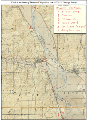
Welch's notations on a 1911 US Geological survey map. Bismarck and Mandan have grown considerably in the hundred+ years since. 

The village along the banks of the Heart River in present-day Mandan, ND was large, with a population of perhaps as many as 3000. Its identified mainly as a Nu’Eta site, but the Hidatsa claim the populace as their own. The Hidatsa became neighbors of the Nu’Eta sometime around 1600 C.E., and inter-married with them over the centuries that today one isn’t Nu’Eta without having Hidatsa relatives.

This large village was known by many names. The Nu’Eta called it Large and Scattered Village. The Hidatsa called it the Two Faced Stone Village for the sacred stone feature atop the plateau overlooking their village. Crows Heart, a principle leader of the Nu’Eta, informed Colonel Alfred Welch that that they called the village there in present-day Mandan, “The Crying Hill Village.” Crows Heart also essayed to Welch that they called it so because their women went to the top of the hill to mourn for lost relatives.

Another village there, south of the Crying Hill Village, called Motsif today, was known by the Nu’Eta as Youngman’s Village. According to Welch’s informants, the Nu’Eta of both these two villages would gather together and inhabit a winter camp in the timber on the floodplain of the Missouri River[1].

According to the late Mr. Joe Packineau, the Crow separated from the Hidatsa at the Crying Hill Village, adding that the village was also called the Tattoo Face Village, and further, that it was Hidatsa, not Nu’Eta. In the time of Good Fur Robe, he had a brother whom they called Tattoo Face. A hunt concluded with a dead bison recovered from the middle of the river. Good Fur Robe divided the kill and took the paunch, which infuriated Tattoo Face and his people, who picked up and moved west. According to Packineau, the Hidatsa called them not Crow, but “The Paunch Jealousy People.” Where the Crow broke away from their Hidatsa relatives was at the Crying Hill Village[2].

Welch drew this diagram mapping the features of Crying Hill. Visit the Welch Dakota Papers site.

At the top of Crying Hill were stone features (including a stone turtle effigy measuring twelve feet across), sacred to the Nu’Eta, upon which were images or pictographs, which changed, and were said to be able to tell the future. One oracle stone in particular, was said known as the “Two Face Stone.” When diviners gathered ‘round to interpret the stone’s musing for the future, they would lift the stone, which seemed to them to be very light. Upon putting it down, they would lift again, and the stone mysteriously weighed more than one could lift. They called this stone Two Face because of its dual nature, and according to Welch’s informant, the village below was called “Two Face Village.” Enemy Heart, an Arikara man, estimated the side of the Two Face Stone to be a diameter of about 18 inches[3], it’s location, at least in 1912, was lay just east of the Morton County Courthouse in Mandan, ND[4]. Enemy Heart insisted that the Crying Hill Village’s proper name was Two Face Village.

In the 1870’s, as the city of Mandan developed on the remains of the Large and Scattered Village, or Crying Hill Village, or Tattoo Face Village, Two Face Village, homes and streets encroached on Crying Hill itself. One day, a prospective home owner, took dynamite to the sacred stone on the hillside of Crying Hill and blew it up[5]. Welch contends that the greater oracle stone was drilled and split by white settlers for building stone. One resident, Mr. G.W. Rendon built the basement of his house from fragments of this holy stone[6].

There used to be a burial ground at Crying Hill. In 1933, laborers of the city of Mandan were expanding development of the city for two new houses, and disturbed the graves of eleven Nu’Eta men and women, including a baby. Col. Alfred Welch was called on to offer his assessment of the findings, and he estimated that the size of the Crying Hill Village at about 3000 souls, and was occupied for about 300 years[7], from ~1500 C.E. to about ~1800 C.E. The bodies were hastily buried, possibly due to the haste in which the survivors departed the Heart River villages in 1781 following the smallpox epidemic which struck them.

This reconstruction of the 1863 Apple Creek Fight is overlaid on 1850's Warren survey map. 

Crying Hill overlooks one of the largest conflicts in Dakota Territory history. In 1863, General Sibley led ~2200 soldiers into Dakota Territory on a punitive campaign from Camp Pope in Minnesota. The campaign concluded at the mouth of Apple Creek, on Aug. 1, 1863, when Sibley withdrew from the field of conflict, unable to pursue the Lakȟóta across the Missouri River. The Húŋkpapȟa, led by Black Eyes, crossed the Missouri River where the Northern Pacific Railroad Bridge spans the river, and thence up the Heart River to escape pursuit.

A week after the Apple Creek conflict, Black Eyes brought the Húŋkpapȟa back across the Missouri River and re-crossed the Missouri at the northern most mouth of the Heart River (which had three mouths at that time), and camped above the floodplain opposite Crying Hill. During the night, miners from Fort Benton, MT came down and camped on a sandbar. The next morning the miners tried forced themselves on a Lakȟóta woman who had gone down to the river to refresh herself. She died at the miners’ hands; Black Eyes retaliated and the Húŋkpapȟa warriors awoke and hurried to the river’s edge and exchanged gunfire with the hostiles. During the fight, the boat’s swivel gun misfired into the boat itself causing a fire to break out. The miners were killed to the last man, and there precious gold was scattered about the sandbar[8].

The Mandan Historical Society features this photo of the "Mandan Hill" in the summer of 1959. Visit the Mandan Historical Society today.

In 1934, a local Boy Scouts troop arranged forty-seven truckloads of local stone into giant letters which spelled out “MaNDan,” on what became renamed “Mandan Hill.” It was maintained by the Boy Scouts, Girl Scouts, and the Mandan Jaycees over the years, then in 1968, after Interstate 94 (I-94) was complete, the “MaNDan” sign was reconstructed in concrete. In the late 1990’s, pine trees were planted on the south face of Crying Hill arranged to spell “MANDAN[9].”

Sometime in 2003, Mr. Patrick Atkinson, acquired 4.7 acres of what remained of Crying Hill, to save it from development. Atkinson heard that the property was going to be put on the market, and he dashed up to Crying Hill after hearing a little about the lore, and provoked by his own winter memories of sledding down the face of Crying Hill. He took his son to the site to talk about what it meant to them. They concluded to save what they could. Atkinson maintains that the Crying Hill preservation effort is ecumenical and non-political, preserving the site for the sake of the sacredness and inspiration found there by native and non-native alike[10]. Visit Atkinson's site about Crying Hill.

In 2008, Preservation North Dakota declared that Crying Hill was endangered. To be declared endangered, a site must be of historical, cultural, or architectural significance and in danger of demolition, deterioration, or substantial alteration due to neglect or vandalism. Preservation North Dakota acknowledged the preservation efforts of Atkinson and the Crying Hill preservation coalition for saving Crying Hill for the edification and gratification of future citizens.

Dakota Wind is an enrolled member of the Standing Rock Sioux Tribe. He is currently a university student working on a degree in History with a focus on American Indian and Western History. He maintains the history website The First Scout.


[1] Welch, Alfred, Col. "Good Fur Blanket Was Mayor Of Mandan In 1738 - Proof Is Found Of Ancient City On Present Site." Mandan Daily Pioneer (Mandan), April 14, 1924.
[2] Welch, Alfred, Col. "Joe Packineau's Verson of The Split and Formation of Crows." Welch Dakota Papers. November 15, 2011. Accessed August 2, 2017. http://www.welchdakotapapers.com.
[3] Welch, Alfred, Col. "Arikara Hide Their Sacred Stone From The Sioux." Welch Dakota Papers. November 15, 2011. Accessed August 2, 2017. http://www.welchdakotapapers.com.
[4] Welch, Alfred, Col. "More About The Two Face Stone." Welch Dakota Papers. November 15, 2011. Accessed August 2, 2017. http://www.welchdakotapapers.com.
[5] Welch, Alfred, Col. "The Minnitari Stone." Welch Dakota Papers. November 15, 2011. Accessed August 2, 2017. http://www.welchdakotapapers.com.
[6] Welch, Alfred, Col. "Stone Idol Creek Journey." Welch Dakota Papers. November 15, 2011. Accessed August 2, 2017. http://www.welchdakotapapers.com.
[7] "Spades Of Workers Rudely Disturb Last Resting Place Of Ancient Gros Ventres Warriors." Mandan Daily Pioneer (Mandan), May 11, 1933.
[8] Dakota Wind. “The Apple Creek Fight.” The First Scout. Nov. 17, 2014. Accessed Aug. 4, 2017. http://thefirstscout.blogspot.com.
[9] "Mandan Hill 501 N Mandan Ave." Mandan Historical Society. 2006. Accessed August 2, 2017. http://mandanhistory.org.
[10] Crying Hill Heritage Site. 2003. Accessed August 3, 2017. http://www.cryinghill.com


Monday, July 31, 2017

Mandan Woman Turned Into Stone

A lichen covered red granite stone rests in the earth about halfway up the plateau at Fort Abraham Lincoln State Park. Not evident in this photo of this stone, but a rut runs through the half which is exposed to the elements.
Mandan Woman Turned Into Stone
Trees Grew To Honor Her Bravery

As told by Capt. Henry Marcotte (ret.)
Bismarck Tribune, Reprinted Dec. 15, 1922 as “The Clump of Trees on The Hogback”
Mandan, N.D. (TFS) - Fifty years after the construction of Fort McKean and Fort Abraham Lincoln, Captain Henry Marcotte (ret.), shared a story of sacrifice and remembrance regarding a Lakȟóta war party leader, a Nu’Eta (Mandan) man, and a beautiful Nu’Eta woman.

In 1872, Marcotte was serving at Fort McKeen as the Chief of Scouts. In his first summer of service he witnessed many ambuscades carried out on the north side of the newly constructed fort. Marcotte also witnessed the brave responses of the Fort McKeen Detachment of US Indian Scouts - namely, the Sahnis (Arikara). On the evening of November 3rd, Marcotte was invited to sit and smoke with the Sahnis, Hidsatsa, and Nu’Eta, and heard the tale of Black Hare, a Nu’Eta woman.

They had gathered just outside the north side of the palisades of Fort McKeen. It was the custom of Plains Indian men and women to sit on the ground in treaty, in council, at home, and in prayer. Men sat with straight backs and legs crossed; women sat with their knees together, legs tucked under and back, heels to one side. On this day, however, only men were present, and Marcotte undertook to sit on a rock that had been rolled into the circle.

At this gathering, though all spoke different first languages, Marcotte watched and listened to the men speak carefully and deliberately, testing the friendship of all gathered. Sergeant Young War Eagle began the afternoon with a pipe and passed it onto each man calling out his name, who responded in the affirmative. 


By 1910, five trees remained on the top of the plateau, where once was Fort McKeen.

When it was Marcotte’s turn, Young War Eagle recognized him as an officer, then pointed at the rock upon which Marcotte sat. Young War Eagle explained that Marcotte sat on the petrified remains of the Nu’Eta woman known to them as Black Hare. It was to recount her story that brought them together that day. Marcotte doesn’t mention whether or not he removed himself from his perch, but it would have been good manners to do so, and to apologize for his faux pas. Young War Eagle and the men gathered apparently took no offense, and the sergeant recounted the story of Black Hare, as Marcotte noted, “in pleasing tones.”

Black Hare, a young woman, was renowned by many nations near and far for her great beauty. She turned down all her suitors for the simple reason that she didn’t want to leave her village there overlooking the floodplain of the Heart and Missouri Rivers. According to the Sitting Rabbit map of the river, this village was called Watchman’s Village, which today is known as On-A-Slant.

A Thítȟuŋwaŋ (lit. “Dweller On The Plains”; Teton; Lakȟóta) man whom the Nu’Eta knew as Crow Necklace, a leader amongst his people, approached the Nu’Eta and wanted Black Hare for his woman. She declined. Crow Necklace then threatened the Nu’Eta leader with death, to be carried out by sundown, if Black Hare wasn’t brought to him.

The Mandan leader, “To’sh” according to Marcotte’s memory and spelling, induced Black Hare to go walking with him, and on this walk, he took her to where Crow Necklace was lodged, and turned her over to the Xa’Numak (Nu’Eta: lit. “Grass Man”; the Nu’Eta word for the “Sioux”). When To’sh returned to the safety within his palisaded village, he contrived to tell his people that Crow Necklace abducted Black Hare.

The Nu’Eta suspected To’sh’ insincerity, and the other leader of the village - for each village each had a civil chief and a war chief - ordered To’sh to be buried on the spot up to his neck for his disingenuity. The other Nu’Eta leader then made the very threat to To’sh that Crow Necklace made earlier that day, saying that if Black Hare wasn’t here by sundown, To’sh would die. 


By 1922, only one tree remained on the plateau. This photo was taken in the 1930s following the CCC's reconstruction of the three blockhouses. A last tree, dead, can be seen in this image.

From a distance, To’sh saw Black Hare returning to the village, her feet wounded and bleeding. Marcotte’s recollection didn’t tell readers why Black Hare would return in this condition, but other first nations of the Great Plains knew by cultural understanding that when a Lakȟóta man stole a woman from another tribe with the intention of making her his wife, he removed her háŋpa (her moccasins) so that she would be less likely to return to her people. Makȟóčhe Wašté (lit. “The Beautiful Country”; the Great Plains, and by extension, North America) is fraught with uŋkčéla ( little cacti). In this story, Black Hare was a strong-willed young woman to leave her captor and return.

To’sh feared that Black Hare’s return would reveal his falsehood, and earnestly prayed for her to turn into stone. Lo! Black Hare turned into a red calcined stone (as Marcotte described his seat)! A bird sang out during this transformation, and a spirit planted seeds in Black Hare’s bloody footprints. Winter spread its mantle of purity over the stone of Black Hare and her seeded tracks. The sun warmed the land and from Black Hare’s innocent blood grew trees to shade and shelter her stone memorial.

The stone is near Watchman’s Village, within present-day Fort Abraham Lincoln State Park, about halfway up the plateau. When the 17th Infantry arrived, they cut all but eight trees, which were transplanted in front of the officers’ quarters at Fort McKeen. Black Hare’s stone lay on the hillside, bereft of shade and shelter. The water wagons used the stone to check and hold the rear wheels to afford the mules momentary rest.

In 1922, one last tree remained on the hilltop.


Marcotte's narrative appeared as "The Clump of Trees on The Hogsback" in The Bismarck Tribune, Dec. 15, 1922. 

Dakota Wind is an enrolled member of the Standing Rock Sioux Tribe. He is currently a university student working on a degree in History with a focus on American Indian and Western History. He maintains the history website The First Scout.


Wednesday, March 1, 2017

Origins Of The Cannonball Stones

A cannonball concretion near Sentinel Butte, ND. Photo by ND State.
Origin Of The Cannonball
How The Stone Is Formed

By Dakota Wind
Cannonball, N.D. (TFS) – Mníšoše (the “Water A-stir;” Missouri River) is perhaps as old as 80 million years. Before the Quaternary Ice Age, the river ran north and drained into Hudson Bay. Following that ice age, the river altered its course and flowed east and south. The Lakȟóta worldview perspective observes that over time, rivers and mountains change. The Lakȟóta worldview embraces change. Everything changes.

One of the Mníšoše tributaries, Íŋyaŋ IyÁ Wakpá (Talking Stone River; Cannonball River) is a natural landmark, known by the first nations for thousands of years, and later by explorers and traders like the Corps of Discovery, traders, and military expeditions.

The Cannonball River is known by many names. The Húŋkpapȟa and Iháŋktȟuŋwaŋna call it Íŋyaŋ IyÁ Wakpá, or Íŋyaŋwakaǧapi Wakpá (Stone Production [“Cannonball”] River), respectively. The Cheyenne call this same river É’ome’tá’á’e’t, in reference to the cannonball concretions. The Hidatsa know the Cannonball River as Aashihdia, which means Big River. The Mandan Indians, whose earliest historical record goes back to the Cannonball River, call it Pasąhxte’, meaning Big River.

The Mníšoše was known to the Thítȟuŋwaŋ (Dwellers On The Plains; Lakȟóta) as a dangerous river with a deadly undercurrent. Where tributaries converged with the Mníšoše, great wamníyomni (whirlpools) formed in the river. When the first nations crossed the Mníšoše they did so upstream of the wamníyomni. 


A Mandan Village by Karl Bodmer. In the image, Mandan women cross the Missouri River to tend to their gardens on the flood plain of the opposite shore. 

There are two explanations that explain the origin of the cannonball concretions. One mystical, a lesson in holding dear the mystery of creation; the other geological, telling us that these stones have a long history reaching back to a time before humans. In both explanations water is the key to their formation.

According to Jon Eagle Sr., Tribal Historic Preservation Officer of the Standing Rock Sioux Tribe, the wamníyomni at the confluence of the Mníšoše and Íŋyaŋ IyÁ Wakpá, where the energy of one river converged with the energy of another, is where the cannonball concretions were formed. The energy of the wamníyomni created the stones. Eagle contends that after the construction of Oáhe (Something-To-Stand-On; a “Foundation”) Dam, after the creation of Lake Oáhe, the wamníyomni at the confluence of Íŋyaŋ IyÁ Wakpá and Mníšoše, stopped producing the spherical cannonball stones.

Dr. Ray Wood sums up the disappearance of the cannonball concretions in his Prologue To Lewis And Clark, “the banks and valley of this stream once were home to uncounted spherical sandstone concretions that ranged from a few inches to several feet in diameter. Some of them indeed were the size of cannonballs. Today they have been carried away by curio hunters in such numbers that they are very rare.” 


Bluemle explains how the Missouri River once drained into Hudson Bay. Visit his amazing website explaining the geological history of the Great Plains: johnbluemle.com

John Bluemle Ph.D. (former State Geologist for the state of North Dakota) explains the cannonball stones’ process through cementation. The cannonball stones “form as a result of the selective deposition from water of cementing materials in the pores of the sediment,” and, “All the geologic formations in western North Dakota contain concretions and nodules of many sizes and shapes.” Bluemle states in his work The Face Of North Dakota, that “some concretions are nearly spherical, some long and tubular, and others have irregular shapes.” As the landscape erodes around the cemented concretions, the cannonball is revealed.

The cannonball is so important to the identity of North Dakota, that the North Dakota Heritage Center and State Museum features several cannonball concretions outside its east entrance.


Dakota Wind is an enrolled member of the Standing Rock Sioux Tribe. He is currently a university student working on a degree in History with a focus on American Indian and Western History. He maintains the history website The First Scout.


Friday, December 9, 2016

Forgotten History At State Park

A Corps of Discovery Bicentennial medallion is on display near the visitor center at Fort Abraham Lincoln State Park. 
Forgotten History At State Park
Omission Of Prison Camp Narrative
By Dakota Wind
Mandan, ND – On the night of October 21-22, 1804, the Corps of Discovery established camp above the abandoned Mandan Indian Village known today as On-A-Slant, located at present-day Fort Abraham Lincoln State Park. Their mission, one of exploration and science, but also one of peace and friendship.

Seventy-three years later, on October 5, 1877, the Nimiipuu (Nez Perce) concluded a running battle from their homelands in Idaho to Bear Paw Mountain, MT, heart-breakingly short a few miles to US-Canadian border. Their destination: Fort Walsh, to live amongst Sitting Bull and the Hunkpapa Lakota, whom the Nez Perce thought would assist them. Nearly 800 Nez Perce were captured by Col. Miles. 300 of the Nez Perce were imprisoned at Fort Abraham Lincoln in October, 1877, as they were prepared to be shipped to Indian Territory (OK). Some of them died, as prisoners of war, at Fort Abraham Lincoln.

Among the 300 Nez Perce prisoners of war was Tzi-Kal-Tza, or Daytime Smoke, an elder at seventy-one/two years, who survived the military’s single-minded pursuit of his people, had actually fought to defend his people in the Nez Perce War, and was part of their subsequent capture at the Bear Paw conflict, and their relocation to Indian Territory (OK). Information at the Nez Perce County Historical Museum in Lewiston, ID, says that Daytime Smoke was the son of Captain William Clark.

The son of Captain William Clark, Daytime Smoke, who was imprisoned at Fort Abraham Lincoln in October, 1877, where his father once stepped. 

The imprisonment of the Nez Perce survives in living memory today, which isn’t so long ago as one would imagine. “My great-grandmother’s sisters, two of them, died there,” shared Mr. Woodrow Star, an enrolled member of the Nez Perce tribe. “I paid a visit to Fort Lincoln to visit my grandmothers’ graves. None of the park rangers, not even the park manager, had ever heard of this.”

After the fort was decommissioned in 1890, all veterans and citizens at rest there – including the POWs, were exhumed and reinterred at St. Mary’s Cemetery. The Nez Perce were buried in a line, their names unrecorded. Their graves in Bismarck lie there still, in unmarked graves. The Nez Perce today, want to change this.

Fort Abraham Lincoln has seen a lot of reconstruction over the years. Blockhouses and the museum/visitor center have been in place in the 1930’s. Earthlodges were originally reconstructed by the CCC in the 1930’s too, then reconstructed as needed. In the late 1980’s the commanding officer’s quarters were reconstructed, built as General Custer would have known it in 1875. Four other buildings followed. The museum/visitor center was renovated to feature the Mandan Indian and military occupations.

The visitor center features an area dedicated to representing the overnight stay of the Corps of Discovery within present-day Fort Abraham Lincoln State Park.

The museum/visitor center displays feature archaeological findings both from the Mandan and military, Sheheke, (White Wolf; White Coyote) a Mandan who was born there, an artistic diorama of the historic Mandan village there, Fort Abraham Lincoln, General Custer, and the Civilian Conservation Corps. The Little Bighorn campaign and battle are also featured, as is the Corps of Discovery.

Guided tours of the commanding officer’s quarters (“The Custer House”) are offered throughout the tourist season. The guides are dressed in period attire and speak in the present tense as though it’s 1875 rather than the modern day. The Custer House features various novelties that once belonged to Lt. Col. G.A. Custer and his wife. These are pointed out to the visitor by way of a prompt, “Take special notice of…”

The fort’s history is summarized in a prologue and conclusion of every tour: it was built in 1873, a cavalry post to protect the Northern Pacific Railway survey crews, the Black Hills Expedition of 1874 (to confirm the discovery of gold) receives a mention, the Little Bighorn Campaign (Centennial Campaign), the plight of Elizabeth “Libby” Custer following the failure of her husband’s command, the decommission of the fort, citizens dismantling the fort for construction materials in their homes, the CCC placing building markers, and the reconstruction of the fort.

Fort Abraham Lincoln State Park's interpretive programming focuses heavily on the military occupation of the site from 1872 to 1890. 

What is entirely missing from the narrative in the interpretive programming and the museum information about the military occupation is the prison camp history. There is no mention either of the 1875 Treaty of Fort Abraham Lincoln, which was a big activity there at the fort. Lt. Col. Custer called on members of the Arikara, Hidatsa, Hunkpapa Lakota, Mandan, and Yanktonai Dakota to end their generations-long intertribal warring.

The interpretive training that seasonal staff at Fort Abraham Lincoln State Park receive is based on the practices of Freeman Tilden. There are six principles in this methodology. Tilden’s principles are the basics of all interpretive programming found in the National Parks, state parks, museums, and other institutions across the country. Tilden’s principles are:

Tilden's work began with a focus on state parks before his work on interpretive programming was picked up by the National Park Service. 

1. Any interpretation that does not somehow relate what is being displayed or described to something within the personality or experience of the visitor will be sterile.

2. Information, as such, is not interpretation. Interpretation is revelation based upon information. But they are entirely different things. However, all interpretation includes information.

3. Interpretation is an art, which combines many arts, whether the materials presented are scientific, historical or architectural. Any art is in some degree teachable.

4. The chief aim of Interpretation is not instruction, but provocation.

5. Interpretation should aim to present a whole rather than a part, and must address itself to the whole man rather than any phase.

6. Interpretation addressed to children (say, up to the age of twelve) should not be a dilution of the presentation to adults, but should follow a fundamentally different approach. To be at its best, it will require a separate program.

Artistic licence was used to create this reconstruction of the On-A-Slant Mandan Indian village. The layout is slightly different, and according to the archaeological report, there was no ceremonial lodge. 

The whole history of the park is not addressed, so the whole experience of the visitor is not “wholesome.” This omission has shaped the experience of millions of visitors over the years the park has been active. It isn’t just the interpretation or presentation of this tragic history that this is missing; the prison camp history of Fort Abraham Lincoln State Park receives a half paragraph mention in the ND Parks and Recreation Department’s publication by Arnold O. Goplin, “The Historical Significance of Ft. Lincoln State Park” and then only that the 7th Cavalry escorted the Nez Perce to Bismarck, not Fort Abraham Lincoln. In another publication of the ND Parks and Recreation Department, “100 Years – Fort Abraham Lincoln State Park,” the Nez Perce are missing entirely.

An informal visit to the North Dakota Parks and Recreation Department on Thursday, August, 25, 2016, and message for the director went unanswered. An email to the Fort Abraham Lincoln State Park received a reply on Oct. 15, 2016, but only to say that the park manager would respond “next week.” There has been no further follow-up from the North Dakota Parks and Recreation Department. 

The original post cemetery was located at the top of the bluff near old Fort McKeen. 

Mr. Woodrow Star humbly requested any and all information that the North Dakota Parks and Recreation could share with him about his relatives imprisonment. The staff could not respond to Mr. Woodrow, because their information is woefully incomplete. Fort Abraham Lincoln State Park does not employ an actual historian to research and construct their interpretive program. In October of 2015, the park manager referred Mr. Star to me.

Here’s follows a bibliography of non-native primary resources which specifically mention the Nez Perce in Bismarck and at Fort Abraham Lincoln in October of 1877.

Primary Resources:
Fred G., Bond. “Floatboating On The Yellowstone.” 1st Ed. New York, New York: New York Public Library, 1925. 1-22.

Miles, Gen. Nelson Appleton. "The Nez Perce Campaign & The Siege And The Surrender." In Personal Recollections And Observations Of General Nelson A. Miles, 250-280. 1st Printing. New York, New York: Werner Company, 1896.

Zimmer, William F. "Part Two: August 1, 1877 to December 31, 1877." In Frontier Soldier: An Enlisted Man's Journal, Sioux And Nez Perce Campaigns, 1877, edited by Jerome Greene, 89-160. 1st ed. Helena, Montana: Montana Historical Society Press, 1998.

Journals:
Romeyn, Capt. Henry. "The Capture Of Chief Joseph And The Nez Perce Indians." Contributions To The Montana Historical Society, Vol. 2 (1896): 283-91.

Haines, Francis. "Nez Perce Indians." Army And Navy Journal, 1877, 290-91.

Magazines:
Henry Remsen, Remsen (Tilton). "After The Nez Perces." Field And Stream And Rod And Gun, December 1, 1877, 403-04.

"The Surrender Of Joseph." Harper's Weekly, November 17, 1877, 905-906.

Newspapers:
Bismarck Tri-Weekly Tribune, November, 21 & 23, 1877.

Cheyenne Daily Leader, November 25, 1877.

Inter-Ocean, November 23, 1877.

The Nez Perce themselves know their own history. They survived displacement from their homelands, imprisonment, and placement in Indian Territory (Oklahoma).

Goplen, Former Senior Foreman Historian for the National Park Service minimized this tragedy to half a paragraph and displaced the locality to Bismarck, ND. Fort Abraham Lincoln State Park staff have repeatedly ignored calls to address the omission of this history in an effort to preserve the lionized integrity of an egotistical and incompetent military commander. The Fort Abraham Lincoln State Park website focuses only on the Mandan Indian and military occupations and provides a link to Little Bighorn History. There is a pattern of omission of historical fact that is taking place at Fort Abraham Lincoln State Park. One can only hope that this changes. 

Visit this park. It's still the greatest park in North Dakota. Ask the park manager to develop the interpretive narrative. It doesn't need to be apologetic. It needs to be informed. 

Friday, September 23, 2016

Historical Conflict And Trade At Cannonball River, A Review


Challenges And Conflict On The Cannonball
Confluence Of Indians & Traders, A Review
By Dakota Wind
Cannonball, ND – Is the Cannonball River so different today than it was two hundred years ago? Yes and no. The river still drains into the Missouri River as it has done for thousands of years, but the similarities depart from there. The Cannonball River drains into a stretch of the Missouri River that is more lake now than flowing stream.

600 years ago, the Mandan lived in two earthlodge villages, the Big River Villages, on the north and south banks at the Cannonball River and Missouri River confluence. The Cheyenne lived in an earthlodge village located at present-day Fort Yates, ND, and occupied the region including the Cannonball River from around 1700 to about the turn of 1800 before taking up the nomadic horse culture for themselves and moving west. The Arikara contested the Cheyenne occupation, and even came to live at the Big River Village on the north bank for a time.

Tracy Potter’s “Sheheke: Mandan Indian Diplomat” offers a summary of the backstory which sets up the Mandan Indian protagonist Shehek Shote (“White Wolf;” aka Sheheke, or “White Coyote”) in the post-contact and early trade era on the Upper Missouri River. Potter references living oral tradition of the Mandan people, and archaeology of the ancient territory of the Mandan, as well as writings from the early fur traders including the Corps of Discovery to show the struggle and survival of the Mandan on the prairie steppe.

Potter’s teeters back and forth between a biographical epic of White Wolf who journeyed east to parlay with President Jefferson and his return, and a historical summary of the Mandan people. The tale concludes with a grand gesture of self-sacrifice and service to a country that has largely forgotten that White Wolf died protecting Americans on the frontier when the War of 1812 spread to the Missouri River.

Sheheke: Mandan Indian Diplomat was released in 2003 as a companion book to all the Corps of Discovery excitement during the Lewis & Clark Bicentennial. Its a genuine original concept, with a focus on the story of a native man, a civil chief of a peaceful first nation, at a time when a dozen books a month were coming out about the Corps of Discovery. It’s 2016 and Potter’s book deserves a second closer look at its brief narrative involving the conflicts on the Cannonball River in light of the current energy interests there.

Inter-tribal conflict is a part of the collective history of the first nations. Different languages yield different world views and values, which may lead to conflict, but contests for control of natural resources is universal in the history of humanity anywhere in the world at any time.

During the Corps of Discovery’s mission, they selected various tribal leaders to journey downriver and east to meet with the great father of the new United States. In 1804, the corps selected Arketarnawhar Was-to-ne (“Is A Whippoorwill”) and a company of six others from the Osage, Missouri, and Pawnee nations, to entreat with President Jefferson. Is A Whippoorwill died in the spring of 1805; the other tribal representatives soon died as well. Jefferson wrote a missive telling the Arikara that their beloved leader had promised their friendship to the Americans before dying, and that he was buried in the east.

The Arikara received official word of their leader’s death in the summer of 1807. By then, the Arikara and Mandan were at war with one another. One of the conflicts between the two nations was at the Cannonball River, where the Mandan had fought the Arikara and killed two of their warriors. The Mandan wanted and supported trade with the Americans; the Arikara wanted the same too, but wanted their leader back more.

In the fall of 1812, war tension spread west. The Hidatsa supported the English in their trade. The Mandan supported trade with the American Fur Company. The Arikara indiscriminately harassed all white trappers and traders on the Upper Missouri. The Cheyenne were withdrawing from the Missouri River for the deep west, but lingering trade drew them back to the Missouri River. The American Fur Company had set up shop with Fort Manuel Lisa near present-day Kenel, SD near the ND-SD border.

The Arikara reported to a Fort Manuel trader that the Cheyenne had robbed and whipped a trader at the Cannonball. The trappers were so nervous when the sun went down, they shot a skulking dog thinking it was a Cheyenne. What’s not reported, is the Cheyenne were lied to and robbed in trade themselves. Their retaliation was just. They didn’t kill the trader, only suffered him to be humiliated for his corrupt dealings. Some of the Cheyenne were still on good terms with the traders at Fort Manuel Lisa and had planned on wintering there in 1812-1813.

Fort Manuel Lisa was attacked and burned in December 1812. Lisa and his men, even the Cheyenne were anticipating attack from the Arikara, but it was the Thítȟuŋwaŋ (“Teton”), persuaded by English trade agent Col. Robert Dickson who had married into the Očhéthi Šakówiŋ (“Seven Council Fires;” Great Sioux Nation), who carried the fight to the trade fort.

Potter’s “Sheheke: Mandan Indian Diplomat” is a wonderfully short historical book in clear light prose, but it’s deep and rich enough for serious study. His book is dedicated to the Mandan people and includes many Mandan and Hidatsa descendants in his acknowledgements. Get your copy from the North Dakota Heritage Center & State Museum store. The book isn’t listed on the website, but it’s available on the floor. Get your copy today! 


Friday, August 19, 2016

At The Heart Of The World, A Review

The cover features a beautiful scene by American western artist William Jacob Hays, Sr., straight from 1863, and a Karl Bodmer painting of the Mandan Mandeh Pahchu in 1840. 
At The Heart Of The World, A Review
Survey History Reveals Native Homesteads
A Book Review By Dakota Wind
Bismarck, ND – In March 2014, Dr. Elizabeth Fenn’s seminal work on the history and culture of the Mandan Indians Encounters At The Heart Of The World: A History Of The Mandan People was published. The following year her work won the Pulitzer Prize for History.

Fenn is a historian. Naturally, she meticulously researched the primary resource documents like journals and maps. She isn’t an archaeologist or a geologist, and she’d be the first to tell you, but she immersed herself in the surveys, visited many of the sites first-hand, and then constructed a narrative of her experience of North Dakota making her research a little more personalized with exposition of the modern landscape, and produced an amazing piece of history that is easy to read and follow.

In light of the current energy interests in the Cannonball River vicinity, here follows a ten paragraph excerpt of Encounters At The Heart Of The World which details some history, geology, and cultural occupation:

A map on page seventeen, one of several appearing in Fenn's book. 

THE CANNONBALL RIVER
The Cannonball River starts in Theodore Roosevelt country – at the edge of the North Dakota badlands where, in the 1880s, the Harvard-trained politician found solace and manhood after personal tragedy sent him reeling. From here, the stream flows east across 150 miles of treeless plains and enters the Missouri not far above the South Dakota border. The confluence is today obscured by the waters of Lake Oahe, but there was a time when that confluence intrigued nearly every Missouri River traveler. Scattered along the shoreline and protruding from the banks were hundreds of stone balls, some as big as two feet in diameter.

These stone balls are the product of the ancient Fox Hills and Cannonball sandstone formations, deposited by inland seas that inundated the landscape for nearly half a billion years. Seventy million years ago, continental uplift caused the waters to recede and the sea floor to emerge, visible today as undulating plain. By slicing through this surface to expose the layers of sediment below, the Cannonball River revealed the land’s ancient, hard-to-fathom aquatic history. The Fox Hills and Cannonball strata are rich in minerals, especially calcium carbonate – a vestige of marine animals such as crabs, which often appear fossilized in these formations. When groundwater flows through the sandstone, the calcium crystallizes with other minerals and forms concretions – literally concrete – of a spherical shape.

William Clark, who examined the mouth of the Cannonball as he and Meriwether Lewis headed up the Missouri River on October 18, 1804, noted that the balls were “of excellent grit for Grindstons.” His men selected one “to answer for an anker.” The German prince Maximilian of Weid viewed the distinctive globes from the deck of a steamboat in June 1833, The Cannonball River “got its name,” he explained, from the “round, yellow sandstone balls” along its shoreline and that of the Missouri nearby. They were “perfectly regularly formed, of various sizes: some with a diameter of several feet, but most of them smaller.” Today, they are little more than a curiosity. Local residents use them as lawn ornaments.

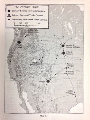
A map from page nineteen detailing continental trade to the Mandan Indian villages. Note: map says "Pre-contact Trade." 

AT THE CONFLUENCE OF THE CANNONBALL AND MISSOURI RIVERS, 1300
For ancestral Mandans, the migration farther north and the construction of new towns may have mitigated the threat of violence. Though they fortified some of their new settlements, they built others in the open, unfortified pattern of old, with fourteen to forty-five lodges spread over as many as seventeen acres. One such town sat on the south bank of the Cannonball River where it joins the Missouri, in what is now the Standing Rock Sioux Reservation.

The South Cannonball villagers tapped a wide array of food resources. In the short-grass prairies to their west, herds of bison beckoned hunters. In the mixed- and tall-grass lands across the Missouri to the east, antelope, deer, and small game did the same. The riverbanks brimmed with seasonal chokecherries, buffalo berries, serviceberries, raspberries, plums, and grapes, while river-bottom gardens produced a bounty of maize, beans, squash, and sunflowers. The Missouri itself offered catfish, bass, mussels, turtles, waterfowl, and drowned “float” bison, this last considered particularly delectable.

Much of the South Cannonball village site has succumbed to the steel plows of more recent farmers tilling the soil here, but the layout of the ancient village is clear. The settlers dispersed their town over fifteen acres, with ample space between individual homes. The houses themselves, about forty in number, were nearly rectangular log-and-earth structures, narrower at the rear and wider at the front.

There were no fortifications. It appears that the occupants of the South Cannonball hamlet counted on peaceful relations with neighboring villagers and with the hunter-gatherers who may have visited from time to time. But fortified towns nearby suggest that security was tenuous. South Cannonball may have been on the last villages to follow the scattered settlement pattern of earlier days. By the mid-1400s, the same neighborhood was home to some of the most massively defended sites ever seen on the Upper Missouri River.

Fenn’s narrative reconstructs a historic Mandan presence in the vicinity of the Cannonball River. Where Dr. W. Ray Wood focused more on the physicality of the north bank of the Cannonball, Fenn brings a living history lens to the south bank of the same.

Fenn cares about the people she has written about, actually making friends on each trip she takes to the Northern Great Plains. She knows that no matter how carefully she constructed her narrative, that there would be some among the Mandan who don’t embrace her interpretation, and she accepts that even as she acknowledges them. She cares about the history. She cares about the people. Her work reflects that and it is no wonder her work received such acclaim.

You can get your copy of Fenn’s Encounters At The Heart Of The World: A History Of The Mandan People at the North Dakota Heritage Center and Museum’s store. The book isn't listed on the website, but its on the floor.