Showing posts with label Black Hills. Show all posts

Sunday, March 24, 2019

Months of the Lakota Year as told to Rev Peter Rosen


Months of The Lakota Year
As Told to Rev. Peter Rosen

Edited by Dakota Wind
Rev. Peter Rosen was a Catholic missionary for seven years in the Black Hills beginning with his first placement at St. Andrew’s Parrish in Deadwood, Dakota Territory, 1882. Rosen collected any writing he could to acquaint himself with the Black Hills. He collected newspapers, books, copies of government records, church records including the manuscripts of Fr. Pierre DeSmet, and oral stories on his many various trips in and around the ‘Hills.

In 1895, Rosen published Pa-ha-sa-pah, or, The Black Hills of South Dakota: A Complete History. It was a series of six books published as one volume, with the first three focusing on the indigenous occupation of the Black Hills, their mythologies, and long associations with the ‘Hills.

Amongst Rosen’s work is a collection of Lakȟóta names for the twelve months of the year. The Lakȟóta employ a thirteen-month lunar calendar, not a twelve-month astrological one. Rosen recording offers readers a glimpse of both Lakȟóta and Dakhóta names for the times of year, with a few variant names. These month names have been re-written using the Standard Lakota Orthography which was developed by the Lakota Language Consortium; some of these month names appear in the LLC’s New Lakota Dictionary.

January
Theȟí Wí (Difficult Moon)

February
Wičhítegleǧa Wí (Racoon Moon)

March
Ištáwičhayazaŋ Wí (Sore Eye Moon)

April
Maǧáokada Wí (Moon When Geese Lay Their Eggs)
Watópȟapi Wí (Moon When They Paddle Their Canoes)

May
Wóžupi Wí (The Planting Moon)

June
Wažúštečaša Wí (Ripe Strawberry Moon)

July
Čhaŋpȟásapa Wí (Ripe Chokecherry Moon)
Wašúŋpȟa Wí (When The Geese Shed Their Feathers Moon)

August
Wasútȟuŋ Wí (Moon When Things Ripen)

September
Psiŋ’hnáketu Wí (Moon When They Lay Up Rice [To Dry])

October
Wážupi Wí (Drying Rice Moon)

November
Thakíyuȟa Wí (Deer Rutting Moon)

December
Tȟahékapšuŋ Wí (Moon When Deer Shed Their Horns)


Saturday, December 8, 2018

Winter Solstice and the Midwinter Moon

"The Long Night Moon," or Winter Solstice, pictured above, a pictographic representation for the lunar month of the Lakota people. This month will last from Dec. 7, 2018, through Jan. 4, 2019. The crescent represents the moon, or month, the star represents the night, and the arc represents the length of the night. 
Winter Solstice and the Midwinter Moon
They Were Carried When They Fell
By Dakota Wind
The long star-filled nights were a time to remember the myth-history of the people. I imagine a family similar to mine, gathered around a glowing fire, watching the flame, feeling the heat, and listening to the voice of ancient authority in a line of grandmothers and grandfathers going back to their elders and those before them.

The first snow was celebrated. Men put on their snowshoes and danced in the fresh powder. The snow made for ease of hunting. The Lakȟóta explained the changing of the seasons as an epic battle between two brothers: Wazíya (The North) and Okáǧa (The South). As one retreated, the other gained ground. When Wazíya won, his breath blew across the landscape, and for as deadly and sharp his cold breath might be, he brought a blanket of snow under which Uŋčí Makȟá (Grandmother Earth) slept.

The High Dog Winter Count recalls the year 1800 as one of the most challenging years to survive. The summer heat was unbearably hot. The great gangs of bison went away, and hunting was poor. Flowers disappeared from the landscape, and the wind drank up the water. The birds refused to sing too.

The punishing summer was followed by a harsh winter.

Winter came, snow and ice were everywhere. According to the White Bull Winter Count, a group of Lakȟóta decided to move winter camp from the bottomlands of one river to that of another. As they moved over the high plains, a blizzard caught them. Gradually some of them began to succumb to the cold and fell. As one person fell, another lifted and carried him or her the rest of their journey. Kičhíč’iŋpi keúŋkiyapi, “They say that they carried each other.” 


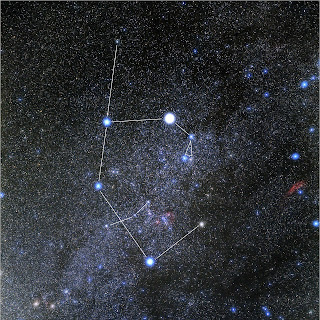
This constellation is commonly known as "Auriga" is as it would be seen in the middle of the night during the Winter Solstice. The biggest star closest to the middle of the crescent is commonly known as Capella. 

By firelight and starlight, the Lakȟóta used the time of the long winter night to share stories like that of Wičháȟpi Hiŋȟphaya (The Fallen Star; also called “Star Boy”). The story of his mother, Tȟapȟúŋ Šá Wíŋ (Red Cheek Woman), and father, Wičháȟpi Owáŋžila (The Star that Does Not Move; “The North Star”) is fairly well known.

According to Ronald Goodman’s work in his Lakota Star Knowledge, Fallen Star was renowned among the Lakȟóta as “the Protector, the bringer of light and higher consciousness.” After becoming a father, Fallen Star ascended “a hill at night with a friend,” and told him that he was going to return home. Fallen Star laid down upon the hilltop and died. His spirit was seen a light that rose into the star world. “At some time in the past, all Lakȟóta acquired the gift of light he brought them.” (Goodman, 2017; 32) Goodman’s work says that human beings are composed of matter and light.

In 1967, Helen Blish published her thesis A Pictographic History of the Oglala Sioux, featuring the works of Amos Bad Heart Bull (~1868-1913), a noted Lakȟóta artist, amongst of what was a map of the Black Hills and other features including Pahá Ská (White Butte). White Butte is noted as being north of the Black Hills. 


Kapemni, an hourglass shape symbolizing what is in the heavens is also on earth. 

Goodman discusses an ancient central symbol strongly associated with the heavens and the world. This symbol is referred to as Kapémni (“the action is swinging around and around,” as with a warclub or bullroar), and resembles an hourglass. One half represents all that is heavenly, the other half represents all that is worldly. What is in the heavens is also present in the world. In the pages of Lakota Star Knowledge, this “mirroring” is demonstrated in a map of the Lakȟóta constellation Čhaŋgléška Wakȟáŋ (The Sacred Hoop) which demarcates the locations of landmarks in and around the Black Hills.

It is a general map; not everything matches up perfectly. Matȟó Thípila (Bear Lodge), or Devils Tower, is not actually within Khiíŋyaŋka Očháŋku (The Race Track), the edge of the Black Hills. The Race Track is the “mirror” of the Sacred Hoop. White Butte is not a part of the Black Hills, but it is north. It is a real butte. It is also the hill upon which Fallen Star made his journey back to the sky. 


White Butte, located in southwest North Dakota near the town of Amidon. 

Like Devils Tower, White Butte appears to be in the narrative of the Sacred Hoop, though it is not so on earth. Yet according to the map of the Sacred Hoop constellation in Lakota Star Knowledge, a star commonly known as Capella, the brightest star in the constellation Auriga appears as part of the Sacred Hoop.

Referencing Bad Heart Bull’s map, and tracking the sky from the Sacred Hoop to the North Star one “sees” the stars associated with the constellation Auriga “pointing” or “reaching” towards the North Star. The constellation Auriga appears to be Kapémni, or "mirror" of White Butte and the immediate landscape surrounding that beautiful plateau. 


The constellation is commonly known as Auriga. The brightest star in this constellation is Capella. If this were the Lakota constellation for Fallen Star it would seem that his arm is raised, perhaps reaching for his father, North Star. 

I suggest that Capella is the Fallen Star, and Auriga is his constellation.

The Lakȟóta share Ohúŋkakaŋ (stories from the distant past) and Wičhówoyake (stories, legends, myth) during the five lunar months of Waníyetu (the winter season), and during this moon especially, they share stories like the Fallen Star narrative. 


Fallen Star, wears a robe symbolizing the day and night, a bow under the edge of his robe. 

Long ago, before the reservation era anyway, the month which some might call December today, was known by some Lakȟóta as Waníčhokaŋ Wí (The Midwinter Moon). They might not have known the exact day, but could reckon the subtle shift in daylight when there was a little more of it and could track the general date with counting sticks; they knew it happened in the Midwinter Moon.

According to Vi Waln, “I believe the real day of prayer was observed on the winter solstice by the people with ceremony, food, and family.” Further, “Nature and the stars were monitored carefully to help with preparation for whatever time of year was upon the people.” And lastly, “Many Lakota people will offer prayer in much the same our ancestors did so on the Winter Solstice.” (Valn, Winter Solstice Is Sacred, 2011)


There are five winter moons in the traditional Lakȟóta calendar. After the Winter Solstice, it was time to gather red willow (eastern dogwood) to make čhaŋšáŋšaŋ, a traditional tobacco made from the inner bark of the red willow, and used for ceremony. 

In the heart of winter, in daylight, there sometimes appears the sundog. The Lakȟóta call it Wíačhéič'thi, which means "The Sun Makes A Campfire [For Himself]." Sometimes, during the winter nights, they see a ring around the moon, also called Wíačhéič'thi, only this is interpreted as "The Moon Makes a Campfire [For Herself]."

The New Lakota Dictionary lists the Winter Solstice as Waní-Wí-Ipȟá (Crest of the Winter Sun). The Húŋkpapȟa might call the same Haŋyétu Háŋska (The Long Night) as they called this traditional month Haŋyétu Háŋska Wí (The Long Night Moon).

However it is called this day, or this month, these things are certain: gather close together with family in observation or prayer, eat together, share stories, and carry each other.


Tuesday, April 11, 2017

A Review, Red Cloud, A Lakota Story of War and Surrender

A Review, Red Cloud 
A Story Of War And Surrender
By Dakota Wind
Bismarck, ND (TFS) – “I was born a Lakota and I have lived as a Lakota and I shall die a Lakota,” said Red Cloud. So opens S.D. Nelson’s Red Cloud: A Lakota Story of War and Surrender, a first-person narrative of the Lakȟóta leader Maȟpíya Lúta, Red Cloud, and the history of his people before his birth, through his life, and death in the confines of the Pine Ridge Indian Reservation in what became South Dakota.

Similar to Nelson’s Sitting Bull: Lakota Warrior and Defender of His People, Nelson tells this story by rendering a beautifully and fully realized world in the historic Plains Indian style of art reproduced here as though on a ledger book.

Red Cloud’s story breaks down the complexity of inter-tribal conflict, and the great struggle for resources and tribal sovereignty on Makȟóčhe Wašté, the Beautiful Country (Great Plains; North America). The two Fort Laramie Treaties are touched on, an agreement between nations, and how both were broken by the United States.

Red Cloud’s War is retold with this new pictography, and first-person narrative. The evolution of Plains Indian warfare grows from personal conflict and honor to organized military strategy. Red Cloud’s War is one of the wars the United States lost, a concession of the war was that the Lakȟóta shut down the Bozeman Trail and retain control of Powder River Country, but this was short-lived.

The decision for Red Cloud to sign the 1868 Fort Laramie must have caused a great internal struggle for the Lakȟóta leader and the people who followed him. The first-person narrative captures this struggle, “For the sake of my own people, those who followed, me, I accepted and signed the new treaty papers. But of course I did not represent the desire of all the people. Opinions were divided.”

The story of Red Cloud is taken up to his death, followed by a reflection on the journey of his people. Red Cloud’s story isn’t finished because his life came to an end, his story continues because his people continue.

There are books that deserve to be taken apart, but Nelson’s book literally deserves to be taken apart if only to frame the pages. Such pages are 4 (men astride their horses in water), 16 (meeting at Fort Laramie in 1851), pages 20 & 21 (the pipe dance), pages 29 & 29 (Red Cloud’s challenge of the Bozeman Trail), page 33 (a war party), and page 49 (the post-death reflection).

S.D. Nelson is a member of the Standing Rock Sioux Tribe. His traditional name is Maȟpíya Kiŋyáŋ (Flying Cloud) He is an award-winning author and illustrator of numerous children’s books. His books have received many accolades, including the American Indian Library Association’s Youth Literature Award, a place on the Texas Bluebonnet Award Master List, and the Western Writers of America Spur Award. Nelson lives in Flagstaff, AZ. Follow him online at sdnelson.net.

Nelson, S.D. Red Cloud: A Lakota Story of War and Surrender. First ed. New York, NY: Abrams Books For Young Readers, 2017. 64 pp. $19.95. Hardcover. Photos, illustrations, timeline, notes, bibliography, index.


Dakota Wind is an enrolled member of the Standing Rock Sioux Tribe. He is currently a university student working on a degree in History with a focus on American Indian and Western History. He maintains the history website The First Scout.

North Dakota Content Standards
Grades 4 and 8
Resources: 4.1.4; 8.1.2
Timeline: 4.1.5
Concepts of time: 4.2.2, 4.2.3, 4.2.4
People and events: 4.2.5
Colonization: 4.2.9
Expansion: 4.2.10
Physical geography: 4.5.3; 8.5.1
Human geography: 4.5.5, 4.5.6; 8.5.2, 8.5.3
Culture: 4.6.1, 4.6.2; 8.6.2
US History & Imperialism: 8.2.4, 8.2.9, 8.2.10, 8.2.11


Wednesday, July 22, 2015

Coolidge Remembered As Bear Ribs

President Coolidge seen here with members of the Sicangu Lakota people.
Coolidge Recognized With Lakota Name
Standing Rock Sioux Call Him “Bear Ribs”
Edited by Dakota Goodhouse
Bismarck, N.D. (Bismarck Tribune, July 1927) – The following appeared in the Bismarck Tribune, summer 1927, when three tribal community members sent a letter to President Coolidge. These three later met the President in the Black Hills, August 1927, when he established summer camp near Spearfish, S.D.

President Coolidge has been adopted by an Indian tribe, which has given him the name Bear Ribs, meaning the Indian conception of the chief who originally bore that name as “a far seeing, progressive man.” Another honor bestowed upon the President is the gift of an Indian pipe and beaded tobacco bag. He intends to smoke the pipe, he said, although he does not enjoy pipe smoking.

News of the President’s adoption came to the White House in a letter signed by the committee of three Indians, living on the reservation near Fort Yates, N.D. as follows:

Hon. Calvin Coolidge
President of the United States,
Washington D.C.

Dear Mr. President:

The Indians of the Kenel District on this reservation at their local council desire to congratulate you upon your re-election and take pleasure in mailing you, under separate cover, a pipe and beaded tobacco bag.

Presidents in the past have done much in reference to the Indian and his destiny, but it remained for you to give to the Indian that citizenship which he hoped for through many years. We desire to express our heartfelt appreciation for the citizenship granted us, and also for the good judgement shown in protecting our property rights and by not turning them over to the Indians without supervision. To turn the property rights over without protection would have been a great misfortune to us.

For many years the Indian has doubted the government’s good intentions, but we now know that it had a definite purpose in view and that the government’s ultimate intention was to train us for citizenship.

Many years ago when trouble arose between the Indians and the soldiers under a white general we called White Beard, we fought the soldiers, but later there came peace between us. At that time Bear Ribs, a progressive chief of the Hunkpapas [Huŋkphápȟa], tried to teach us the white man’s way.

The Indians objected to learning this new way, and as a result Bear Ribs was finally murdered because of his progressive ideas.

We now know that Bear Ribs was right, and we honor his memory. Because Bear Ribs was a far-seeing, progressive man, we now give you the name Bear Ribs, by which you will be known to our tribe.

Very respectfully,
Antoine Claymore
Jovita Badger
Pius Shoots First

Monday, August 13, 2012

Pe’ Sla: The Heart Of All That Is, Sacred Site of the Lakota is Threatened

Gratify yourself with a copy of this beautiful book "Lakota Star Knowledge: Studies in Lakota Theology" by Ronald Goodman. Contact your nearest bookstore or order one off of Amazon, after you've donated a little something to the LastRealIndians to preserve Pe'Sla.
Pe’ Sla: The Heart Of All That Is
Sacred Site Of The Lakota Is Threatened
By Chase Iron Eyes, Last Real Indians 
RAPID CITY, S.D. - Right now, the Oceti Sakowin (The Seven Council Fires), aka The Great Sioux Nation is battling against the clock to save one of its most sacred sites, Pe’ Sla, The Heart Of All That Is.  Pe’ Sla, located in the center of the Black Hills of South Dakota, USA, is considered to be the heart of everything that is by the Oceti Sakowin. It is part of their creation story, Pe’ Sla plays a crucial role in the star knowledge of the Sioux. Ceremonies essential to their culture and beliefs, that Tribal elders and spiritual leaders explain help keep the universe in harmony, must be conducted at Pe’ Sla.

On August 25, 2012, the Reynolds Family will auction 1,950 acres in five tracts of land to the highest bidder. Once sold, it is highly likely that Pe’ Sla will be opened up for development; the State of South Dakota is considering building a road directly through it.

We at LastRealIndians believe our sacred places were taken illegally by the United States government, and are collaborating with the Sicangu Lakota (Rosebud Sioux Tribe) and other bands of the Oceti Sakowin to centralize fundraising to save one of our most precious sacred sites, Pe ‘Sla.  In an unprecedented, collective effort the Oceti Sakowin is attempting to buy as much of Pe’ Sla as possible, to save it from destruction and ensure that future generations of the Oceti Sakowin and other First Nations that consider the Black Hills holy, will continue to have access to this vital sacred site to practice their faith on its ceremonial grounds in its natural, pristine state.

Help save Pe’ Sla, the Heart of the Sioux Nation.  Click on this link to make a contribution.  Any amount given, no matter how small, is appreciated:

The Rosebud Sioux Tribe is working with LastRealIndians.com to accept donations from both Tribes and individuals who want to join in keeping religious freedoms for Lakota, Dakota and Nakota people alive and intact at Pe’ Sla.  Send contributions to:

Rosebud Sioux Tribe/Pe Sla
11 Legion Ave., P.O. Box 430
Rosebud, SD 57570

or online with LRI at:www.indiegogo.com/PeSla-LakotaHeartland.  All donations to the tribe are tax-deductible and will only be used toward the purchase of Pe’ Sla.

Additional Contact Info:
Lastrealindians, Inc.
4265 45th Street S Ste 111-39
Fargo, North Dakota 58104
Phone: (605) 268-0434

*Oceti Sakowin (oh-CHAY-tee shaw-KOH-wee), or Seven Council Fires, is the traditional term that the Dakota, Lakota, and Nakota people collectively refer to themselves. There are seven tribes, or bands, that make up the Seven Council Fires: Mdewakanton, Wahkpekute, Wahpetowon, and Sissetowon speak the Dakota dialect; Ihanktowona and Ihanktowon speak Nakota; Teton who speak Lakota. The Teton in composed of seven tribes or bands: Huncpapa, Sihasapa, Mniconjou, Itazipco, Oohenunpa, Sicangu, and Oglala. 

Wednesday, August 10, 2011

Bear Butte, A View From Afar

Bear Butte in the far distance.  It resembles a bear lying down.  Bear Butte is only about six miles north easterly of the Black Hills, but that little distance was enough to hide any view of the Black Hills, until we got a little closer. 
Bear Butte, A View From Afar
Sacred Site From A Distance
By Dakota Wind
BEAR BUTTE, S.D. - Bear Butte is one of the most sacred places in American Indian traditions on the Northern Great Plains. There are over twenty tribes today that revere the Black Hills and Bear Butte, but there are only six late historic tribes that have left archaeological trace evidence of their pilgrimages to the Black Hills: the Lakota, Cheyenne, Comanche, Shoshone, Kiowa, and Crow. Despite that only six tribes have physical evidence proving their cultural and historic ties to the Black Hills and Bear Butte, a continuous cultural occupation dates back 10,000 years. Perhaps hundreds of different tribes journeyed to the Black Hills over thousands of years, the long ago ancestors of the six tribes mentioned above.

The Lakota call the Black Hills Paha Sapa or Hėsapa, meaning simply “The Black Hills.”  The Lakota have the tradition that “we’ve always been here.” 

 The Rosebud Winter Count, also called the Anderson Winter Count, entry for 1755 depicts a man holding aloft what is supposed to represent the Lodge Pole Pine.  This pine is long and slender.  The tree itself is harvested and shaved to make tipi poles. 

The Rosebud winter count has an entry for 1755 marking the Lakota’s entrance into the Black Hills with the pictograph of an evergreen, the Lodge Pole Pine.  My uncle Cedric interprets the Lakota entrance thusly, “We held those Hills as sacred and because we respected them, we defied our own entry to them.  We always knew about them, but skirted the edges of the Hills, keeping them only in sight but didn’t enter them until recent history.”  

That makes sense to me.  It is indisputable that indigenous people have been here for thousands of years and had those years to learn about Unċi Maka, Makoċė, Grand Mother Earth, or Turtle Island as many of our native people refer to the North American continent as. 

 This image of Bear Butte was taken a few miles north of Newell, SD.  Bear Butte is about twenty-five miles south from this point. 

The Elk winter count recalls a rendezvous of sorts at Bear Butte in the 1750s.  There and then, the Lakota took up arms against the Kiowa, smashing the head of one of them and starting a conflict to hold the ‘Hills. 

In 1857, the Lakota held a council at Bear Butte to determine what to do about the growing presence of white settlers, notably miners, in the Black Hills. 

In 1874, General Custer led the Black Hills Expedition from Fort Abraham Lincoln.  His command was guided by a detachment of Arikara Indian scouts and a detachment of Dakota scouts from Santee, NB.  It was the Arikara scouts who discovered gold first, Bloody Knife, General Custer’s favorite scout, recognized the stone for what it was and immediately notified the General.  The Black Hills Expedition was in complete violation of the Fort Laramie Treaty of 1868.  General Custer immediately informed the people of the United States that his expedition confirmed the presence of gold in the Black Hills which set off a gold rush. 

 About ten miles north and westerly of Bear Butte.  A few miles south from where I took this are recently contructed biker bars and campgrounds.  Its distressing to the native community who go to pray at this site to have to see and hear loud music and rumbling motorcycles. 

The Lakota believe that none could own the land, especially the Black Hills.  And it came that during the settlement era of Dakota Territory or South Dakota, that Mr. Ezra Bovee and his family came to settle on the southern slope of the butte and were the landowners by World War II.  The Northern Cheyene sought permission from Bovee and journeyed to Bear Butte on religious pilgrimage to pray for the end of World War II. 

The Bovee family accepted the native pilgrims unto their land and graciously encouraged the continuation of native religious practices. 

The Bovee family lobbied for national park status, to protect the sacred site.  Not attaining National Park Service status, the state of South Dakota brought Bear Butte into its own park system officially designating it Bear Butte State Park in 1961.  Bear Butte became a National Historic Site in 1965. 

A forest fire, or plains grass fire, in 1996 destroyed many of the trees growing on Bear Butte.

A panoramic view of Bear Butte from the south looking north.  One trail winds east and around back again to the Bear Butte proper, another more direct trail takes hikers to the summit.  Medicine ties, or prayer ties, are attached onto various trees along the side of the trails, even on the side of the road in Bear Butte State Park.  For a larger image, visit: https://www.dropbox.com/gallery/36398036/1/Black%20Hills%202011?h=4c9afb

Every August for two weeks is the Sturgis Bike Rally.  Bear Butte is located six miles north and east of Sturgis, SD.  There are several businesses catering to the motorcycle interest groups that are going up outside Sturgis city limits near Bear Butte. 

In 2007, South Dakota Governor Mike Rounds announced a proposal to purchase land easements around Bear Butte to better preserve the ambience of Bear Butte.  Depending on who you are, it was too little, too late for the easement proposal. 

In 2011, Bear Butte became one of eleven sites to be designated that year a “most endangered site” by the National Trust for Historic Preservation. 

Friday, June 3, 2011

War Correspondence from the Front Lines: The Black Hills

This beautiful book has the entire Black Hills Expedition of 1874 faithfully mapped and is profusely illuminated with images of the photos taken in 1874 with photos of those same sites today. This book is by Ernest Grafe and Paul Horsted. Go get yourself a copy and plan a visit to the Black Hills. 
War Correspondence from the Front Lines:
The Black Hills Expedition Of 1874
By Dakota Wind
BLACK HILLS, S.D. - Finerty, a war correspondent for the Chicago Times, offers a retrospective narrative in his book “Warpath and Bivouac: or Conquest of the Sioux,” 1890, about the causes of “Indian trouble,” wars between the Indians, the gold rush to the Black Hills, and depredations and perils that prospectors faced during “Black Hills Fever.”


Captain William Ludlow authored this map of the Black Hills entitled "Reconnaisance of the Black Hills." This map appears in the Grafe and Horsted book. 

There had raged for many years a war between the Sioux Nation, composed of about a dozen different tribes of the same race under various designations, and nearly all the other Indian tribes of the Northwest. The Northern Cheyenne were generally confederated with the Sioux in the field, and the common enemy would seem to have been the Crow, or Absarake, Nation. The Sioux and the Cheyennes together were more than a match for all the other tribes combined, and even at this day the former peoples hold their numerical superiority unimpaired. There must be nearly 70,000 Sioux and their kindred tribes in existence, and they still possess, at least, 5,000 able-bodied warriors, more or less well armed. But times have greatly changed since the spring of 1876. Then nearly all of Dakota, Northern Nebraska, Northern Wyoming, Northern and Eastern Montana lay at the mercy of the savages, who, since the completion of the Treaty of 1868, which filled them with ungovernable pride, had been mainly successful in excluding all white men from the immense region, which may roughly described as bounded on the east by the 104th meridian; on the west by the Big Horn Mountains; on the south by the North Platte, and on the north by the Yellowstone river.


This stereoscopic view of Chief Red Cloud was taken by S.J. Morrow.

Finerty is referring to Red Cloud’s War from the early spring of 1866 to November of 1868. The United States immediately broke the 1866 Fort Laramie Treaty by constructing new forts along the Bozeman Trail. Red Cloud led a series of engagements from 1866 to 1868, known as Red Cloud’s War. Those engagements include attacks on Fort Kearny and Fort Smith to close the Bozeman Trail, the Wood Train Fight, the Fetterman Fight, the Hayfield Fight, and the Wagon Box Fight. The Lakota were held off in the latter two fights, but won the war when Red Cloud was invited to parley at Fort Laramie for a second treaty. Red Cloud refused to parley until the Powder River strongholds were abandoned. They were, and Red Cloud went to Fort Laramie in November, 1868.


A wood engraving of Fort Laramie. This fort served as the meeting place where the treaties of Fort Laramie were signed.

In fact, the northern boundary, in Montana, extended practically to the frontier of the British possessions. About 240,000 square miles were comprised in the lands ceded, or virtually surrendered by the Government to the Indians - one-half for occupation and the establishment of agencies, farms, schools and other mediums of civilization; while the other half was devoted to hunting grounds, which no white man could enter without the special permission of the Indians themselves. All this magnificent territory was turned over and guaranteed to the savages by solemn treaty with the United States Government. The latter made the treaty with what may be termed undignified haste. The country, at that time, was sick of war. Colonel Fetterman, with his command of nearly one hundred men and three officers, had been overwhelmed and massacred by the Sioux, near Fort Phil Kearney, in December, 1866. Other small detachments of the army had been slaughtered here and there throughout the savage region. The old Montana emigrant road had been paved with the bodies and reddened with the blood of countless victims of Indian hatred, indeed, twenty years ago, strange as it may now appear to American readers, nobody, least of all the authorities at Washington, thought that what was then a howling, if handsome, wilderness, would be settled within so short a period by white people. Worse than all else, the Government weakly agreed to dismantle the military forts established along the Montana emigrant trail, running within a few miles of the base of the Big Horn range, namely, Fort Reno, situated on Clear Fork of the same stream, and Fort C. F. Smith, situated on the Big Horn river, all these being on the east side of the celebrated mountain chain. The Sioux had no legitimate claim to the Big Horn region. A part of it belonged originally to the Crows, whom the stronger tribe constantly persecuted, and who, by the treaty of ‘68, were placed at the mercy of their ruthless enemies. Other friendly tribes, such as the Snakes, or Shoshones, and the Bannocks, bordered on the ancient Crow territory, and were treated as foemen by the greedy Sioux and the haughty Cheyennes. The abolition of the three forts named fairly inflated the Sioux. The finest hunting grounds in the world had fallen into their possession, and the American Government, instead of standing by and strengthening the Crows, their ancient friends and allies, unwisely abandoned the very positions that would have held the more ferocious tribes in check. The Crows had a most unhappy time of it after the treaty was ratified. Their lands were constantly raided by the Sioux. Several desperate battles were fought, and, finally, the weaker tribe was compelled to seek safety beyond the Big Horn River.

The 1874 Black Hills Expedition left Fort Abraham Lincoln on July 2, 1874, with about 1200 men. They were guided by the Fort McKeen Detachment of Scouts (Arikara) and a detachment of Sioux scouts up from Santee, NB. Lieutenant Colonel George A. Custer led the expedition and had orders to return by August 30, 1874. He followed the order to the letter, arriving back at Fort Abraham Lincoln on August 30.

At the time, many newspapers criticized the actions of Colonel Carrington, General Crook, and others for being too soft and lenient with the “Indian problem.” Finerty’s writings don’t criticize the soldier or officer who commands; he praised the dead soldiers and officers of failed campaigns like the Fetterman Fight or the Battle of the Little Bighorn as heroes; Finerty took aim at the authority in Washington for exasperating the conditions of war on the American frontier.

Miners pan for gold in the Black Hills. The leftmost miner could very well be a 49er.

Simply telling readers that miners came from the across the country and from the world over isn’t enough for Finerty. Here Finerty indulges in describing from where and how far away miners came just to get to the Black Hills. 


Had the Sioux and Crows been left to settle the difficulty between themselves, few of the latter tribe would be left on the face of the earth to-day. The white man’s government might make treaties it pleased with the Indians, but it was quite a different matter to get the white man himself to respect the official parchment. Three-fourths of the Black Hills region, and all of the Big Horn, were barred by the Great Father and Sitting Bull against the enterprise of the daring, restless and acquisitive Caucasian race. The military expeditions under Generals Sully, Connors, Stanley and Custer - all of which were partially unsuccessful - had attracted the attention of the country to the great region already specified. The beauty and variety of the landscape, the immense quantities of the nobelest species of American game; the serrated mountains, and forested hills; the fine grazing lands and rushing streams, born of the snows of the majestic Big Horn peaks; and , above all else, the rumor of great gold deposits, the dream of wealth which hurled Cortez on Mexico and Pizarro on Peru, fired the Caucasian heart with the spirit of adventure and exploration, to which the attendant and well-organized danger lent an additional zest. The expedition of General Custer, which entered the Black Hills proper - those of Dakota- in 1874, confirmed the reports of “gold finds,” and, thereafter, a wall of fire, not to mention a wall of Indians, could not stop the encroachments of that terrible white race before which all other races of mankind, from Thibet [sic] to Hindostan [sic], and from Algiers to Zululand, have gone down. At the news of gold, the grizzled ‘49er shook the dust of California from his feet, and started overland, accompanied by daring comrades, for the far-distant “Hills;” the Australian miner left his pick half-buried in the antipodean sands, and started, by ship and saddle, for the same goal; the diamond hunter of Brazil and of “the Cape;” the veteran “prospectors” of Colorado and Western Montana; the “tar heels” of the Carolinian hills; the “reduced gentleman” of Europe; the worried and worn city clerks of London, Liverpool, New York or Chicago; the stout English yeoman, tired of high rents and poor returns; the sturdy Scotchman, tempted from stubborn plodding after wealth to seek fortune under more rapid conditions; the light-hearted Irishman, who drinks in the spirit of adventure with his mother’s milk; the daring mine delvers of Wales and of Cornwall; the precarious gambler of Monte Carlo - in short, every man who lacked fortune, and who would rather be scalped than remain poor, saw in the vision of the Black Hills, El Dorado; and to those picturesquely sombre eminences the adventurers of the earth - some honest and some the opposite - came trooping in massess, “like clouds at eventide.”


One of the more famous images of a miner camp in the Black Hills.

In vain did the Government issue its proclamations; in vain were our veteran regiments of cavalry, commanded by warriors true and tried, drawn up across the path of the daring invaders; in vain were arrests made, baggage seized, horses confiscated and wagons burned; no earthly power could hinder that bewildering swarm of human ants. They laughed at the proclamations, evaded the soldiers, broke jail, did without wagons or outfit of any kind, and, undaunted by the fierce war whoops of the exasperated Sioux, rushed on to the fight for gold with burning hearts and naked hands! Our soldiers, whom no foe, white, red or black, could make recreant to their flag upon the field of honor, overcome by the moral epidemic, deserted by the squad to join the indomitable adventurers. And soon, from Buffalo Gap to Inyan Kara [Lakota: lit. “The Stone is Made” or “The Stone Makes;” In reference to the Lakota creation story], and from Bear Butte to Grand Cañon, the sound of the pick and spade made all the land resonant with the music of Midas. Thickly as the mushrooms grow in the summer nights on the herbage-robbed sheep range, rose “cities” innumerable, along the Spearfish and Deadwood and Rapid Creeks. Placer and quartz mines developed with marvelous rapidity, and, following the first, and boldest, adventurers, the eager, but timid and ease-loving, capitalists, who saw Indians in every sage brush, came in swarms. Rough board shanties, and hospital tents, were the chief “architectural” features of the new “cities,” which swarmed with gamblers, harlots, and thieves, as well as with honest miners. By the fall of 1875, the northern segment of the irregular, warty geological formation, known as the Black Hills, was prospected, “staked” and, in fairly good proportion, “settled,” after the rough, frontier fashion.

Yet another image of an early miner camp in the Black Hills. 

Pierre and Bismarck, on the Missouri river, and Sidney and Cheyenne, on the Union Pacific railroad, became the supply depots of the new mining regions, and, at that period, enjoyed a prosperity which they have not equaled since. All the passes leading into “the Hills,” from the points mentioned, swarmed with hostile Indians, most of whom were well fed at the agencies, and all of whom boasted of being better armed, and better supplied with fixed ammunition, than the soldiers of regular army. The rocks of Buffalo Gap and the Red Cañon, particularly, rang with the rifle shots of the savages, and the return fire of the hardy immigrants, many of whom paid with their lives the penalty of their ambition. The stages that ran to “the Hills” from the towns on the Missouri and the Union Pacific rarely ever escaped attack - sometimes by robbers, but oftenest by Indians. All passengers, even the women, who were, at that time, chiefly composed of the rough, if not absolutely immoral, class, traveled with arms in their hands ready for immediately action. Border ruffians infested all the cities, and, very soon, became almost as great a menace to life and property as the savages themselves. Murders and suicides occurred in abundance, as the gambling dens increased and the low class saloons multiplied. Notwithstanding these discouragements, the period of 1874, ‘75 and ’76 was the Augustan era, if the term be not too transcendental, of the Black Hills. The placer mines were soon exhausted, and, as it required capital to work the quartz ledges, the poor miners, or the impatient ones, who hoped to get rich in a day, quickly “stampeded” for more promising regions, and left the mushroom “cities” to the capitalists, the wage workers, the gamblers, the women in scarlet, and to these, in later days, may be added the rancheros, or cattle men.


The last Deadwood stage coach drive.

Morality has greatly improved in “the Hills” since 1876, and business has settled down to a steady, old fashioned gait, but the first settlers still remember, with vague regret, the whisky was bad and fighting general; when claims were held dear and life cheap; when the bronzed hunter, or longhaired “scout,” strutted around in half savage pride, and when the renowned “Wild Bill,” who subsequently met a fate so sudden and so awful, was at once the glory and the terror of that active, but primitive, community.


Wild Bill Hickok, famous gunman and gambler. Shortly after marrying he ditched his bride in Cinncinati for the Black Hills. He was shot in the head playing a round of poker, his cards, a hand of aces and eights became the Dead Man's Hand.