

Devil's Heart Butte
The Story Of Devil's Heart Butte
By Dakota Wind
SPIRIT LAKE, N.D. - I was looking at the North Dakota state map that’s pegged to
my office wall. I don’t know what it is, maybe it was a recent trip out to Heháka Wakpá Makĥoche (Elk River
Country, or Theodore Roosevelt National Park) and I was in the mood to learn what
the Dakota-Lakota people called places before explorers, traders, and settlers
arrived.
There’s a lake in the north eastern quarter of the state. It’s
a fresh water lake that’s been growing and spilling onto shore property. New
islands have been formed, roads have been built higher, fields are underwater,
and the water threatens to rise higher without relent.
The lake is known to the Dakota and Lakota people as Mni Wakaŋ Čhaŋté. Don’t believe Wikipedia
in this, if you look it up there. A word for word translation of the Dakota to
English is Water With-Energy Heart,
which freely translates as Spirit Heart Lake. The calque of Bad Spirit Lake is entirely a
misconception.
There, on the southern bank of the Spirit Heart Lake lay the
Spirit Lake Sioux Indian Reservation, home of the Spirit Lake Oyate (Nation).
The Spirit Lake Oyate has about 6,700 or so enrolled members, but not all live
on the reservation.
The lake, Spirit Heart Lake (aka Devil’s Lake), the people
(the Spirit Lake Oyate), have a name in common with a site on the reservation near
the town of Tokio (a strange word in and of itself; said to named after the
Dakota word for “Toki” for “gracious gift,” but it isn't; the closest word for gift, is in
the act of receiving a gift, “Okini”). There, nestled
among the rolling hills of the prairie land overlooking the lake is Spirit
Heart Butte, only it’s popularly known as “Devil’s Heart Butte.”
I turned to Spirit Lake tribal historian Louie Garcia to
find an answer. I’ve conversed with Louie on the phone over the years and by
email. I had always thought he was perhaps a middle-aged gentleman by the
youthful exuberance of his voice. Some voices age. Louie’s voice does not. He’s
in his 70's, a respected member of the tribe, he’s gracious to give me an answer, and he wants me to share it with others.
Louie has asked me to post it as he sent it to me, word for word. Pilamiya pelo, Lekshi Louie! He Even included a bibliography and a glossary of Dakota terminology (at the end of this entry).
__________
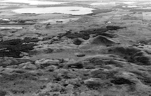
Heart Hill
is a treeless kame located one mile northwest of Tokio, North Dakota in
Section Four Woodlake Township (T152N – R64W) Benson County. It sits on the
eastern edge of the Backbone, a line of hills formed when Spirit Lake
(Devils Lake) was formed some 10,000 years ago during the last ice age. With an
elevation of 1725 feet above sea level it can been seen on the horizon for
miles in the lake region, and from its summit one can look over a vast area
surrounding this hill. The name ‘heart’ means that it is at the center of the
area but also the center of spiritual knowledge. As this hill appears to be in
the shape of an upside down human heart, some incorrectly speculate this as the
reason for its name.
Heart Hill
is the most sacred elevation in all of North Dakota. It could be considered a
cathedral. This Butte de Coeur of the French fur traders is called in the
Dakota language Miniwakan Cante Paha
or Heart Hill at Spirit Lake. The French fur traders named Devils Lake
so that presently the term ‘devil’ is attached to many local geographical
features. “Devils Heart” is the
name used by local people. Naturally the ‘devil’ word is a misunderstanding,
but referring to the Water Spirits who live in the lake.
This Heart
Hill is a sacred location because it is the Lodge of the Water Spirit
for whom Spirit Lake is named. These spirits are called Unktehi or
Terrible Ones due to their custom of drowning anyone who foolishly ventured
upon the lake without their permission. These Unktehi are worshiped in the
Wakan Wacipi or Grand Medicine Ceremony (Skinner 1920:273).
This hill
belongs to a class of sacred lodges (hills) where the spirits meet to decide
the help, if any, they will grant humans. Prehistorically the waters of the
lake flowed up to the east side of this hill, to the door or entrance of this
the Water Spirit’s home. The spirits could enter and exit their home to do
their business within this sacred lake. Unfortunately the entrance to this
sacred hill was blown closed with dynamite in the 1930’s when a local rancher
discovered a den of coyotes living within. If one looks closely at the change
in vegetation, the location of the former entrance can be discovered.
There are
many heart hills or buttes in the state but this most important one is at
Spirit Lake. Examples of other heart hills are: The Heart of the Turtle
Mountain or as it is known today Butte Saint Paul. It is located in Cordella
Township (13-162-74) Bottineau County. There is also a Heart Butte located
on the Ft. Berthold Reservation (9-148-92) in northeastern Dunn County.
Cavalier County has a Heart Butte (19-162-62), as well as Grant County
(23-137-89).
Thomas F. Eastgate
records in his notes two northerly connected hills who he calls ‘sisters’
to Heart Hill (Eastgate). This must be a non-Indian name or a mistranslation as
features on the earth are considered male. As an example there is a Sanborn
Hill or “Heart Hill’s Little Brother”
located in Heman Township (1-139-59) Barnes County named for its exact
appearance but smaller stature than the hill presently under discussion.
The Spirit
Lake area formerly belonged to the Hidatsa. Their main earthlodge village was
located on the west end of Graham’s Island, now a peninsula jutting into
northwestern Spirit Lake (Devils Lake). The Hidatsa name for Heart Hill is Mirixopa Nata Sh or Heart of the Holy Water.
Hidatsa traditions acknowledge the tribe was ‘born’ at Heart Hill. In a
narrative similar to the European tale of Jack and the Bean Stalk, the tribe
emerged from an underworld by climbing a vine. Unfortunately the vine broke
leaving half of the people in their subterranean world. The Hidatsa departed
the Spirit Lake area circa 1550 when their leader was told in a dream to move
west to the Missouri River (Bowers 1992:22; Milligan 1972; Libby Papers Box 29:
folder 14; Kittleson 1992:15).
The Hidatsa
have many Lake Region legends and tales, especially about geophysical features.
One story that is remembered, tells of them making a stone effigy of a bear on
the north side of Heart Hill. A bison effigy is mentioned too. Dana Wright was
shown a trail of 385 stones leading 450 feet to the west from the hill (Roy
Johnson Papers).
In 1839
Nicollet visited the area to map the lake and surrounding area. He drew a
sketch map from the top of the hill. Today one can see the same view of Black
Tiger Bay just as it was drawn some 166 years ago because little has
changed (Bray and Bray 1976:192).
I have a
reference to this hill in 1855 bring called Clarence Peak.
Dr. Charles
Eastman writes in his book Indian Boyhood of visiting Heart Hill in the
1860’s and was informed a great medicine man named Cotanka (Reed or Flute) was buried on top (Eastman 1971:163). A man
by the name of Charles Belgarde is also buried on top of the hill (St. Ann’s
Centennial). In June of 1992 a group of Crow Indians from Montana ascended the
hill and erected two shades for the purpose of a vision quest. A four post
shade was erected on the top at the west end, and another on the east end. A
year later local children began to dig in the abandoned post holes and
discovered a skull and arm bones. The bones were eventually sent to the State
Historical Society of North Dakota in Bismarck for evaluation (Devils Lake
Journal).
Father
Genin on March 4, 1868 erected a thirty three foot tin laminated oak crucifix,
but it was destroyed by a prairie fire, or a wind storm. On July 22, 1873
another cross of glass and steel construction replaced the wooden cross (Cory-Forbes
Papers: Box 2; Norton 1931:163). Both crosses were said to be spectacular when
they reflected the suns rays. Some say that glass particles can still be found
at the base of the hill, remnants of the second cross. Father Genin (Richard
1975:3) renamed the hill The Sacred Hearts of Jesus and Mary, a name closer to
the original intent of the Indians. It is better than the present non-Indian
name of Devils Heart (Cory-Forbes Papers: Box 2).
I was told
that in1924, on a day with a clear blue sky a local church group went to Heart
Hill for a picnic. They sang a hymn and the minister said a prayer, a single
white cloud approached and poured hail and lighting upon them, sending them for
cover. From a religious aspect one could say the Thunders were attacking the
Water Spirits lodge.
Heart Hill
has been used for recreational purposes during the last century. There is a
photograph of a ski jump built upon the top of the hill. It has been a favorite
hiking destination as well as winter sledding, especially for local school
classes. By the 1930’s the ski jump was moved to a location by Highway 57 where
its skeleton can be seen today. Yearly a wagon train camps for one night at the
base of the hill. It is a favorite site to take visitors who have the stamina
to climb to the top.
Most
if not all you readers would naturally assume the Spirit Lake Tribe owns this
sacred hill. You would of course be wrong. When the Spirit Lake Reservation
land was allotted to individuals in accordance with the Treaty of 1872-73 and Dawes
Act of 1887, no tribal member selected the hill. The ownership of land was
against Indian thought. How could anyone think of owning a sacred location? No
one can own land, it belongs to God. When the reservation was opened to
non-Indian ownership in 1904, the hill was selected by a Whiteman and remains
so today. However if we analyze the situation, this non-Indian really doesn’t
own Heart Hill, all he has to do it not pay his taxes for five years.
Bibliography
Bowers,
Alfred W. Hidatsa
Social and Ceremonial Organizations.
University
of Nebraska Press, Lincoln and London 1992.
Bray Edmund
C. Joseph N.
Nicollet on the Plains and Prairies: Expeditions
Bray,
Martha Coleman of 1838 39 with
Journals, Letter, and Notes on the Dakota
Translators
and editors Indians. Minnesota
Historical Society Press, St. Paul; 1976.
Centennial
Committee St. Ann’s
Centennial, 100 years of Faith 1885 – 1985
Turtle Mountain Indian Reservation, Belcourt,
ND
Cory –
Forbes Papers (1853
-1927) A-C833 Box 2, Minnesota Historical Society,
St.
Paul. Three boxes and 10 volumes.
(Father
Genin and the crosses)
Devils Lake
Journal “B.I.A. Probes Bone
Discovery” May 19, 1993.
Eastgate,
Thomas F. Papers. (1855-1907)
Location unknown.
Formerly located in Larimore, ND.
Withdrawn
by family possibly to Minot, ND.
Eastman,
Charles A. Indian Boyhood.
Dover
Publications, Inc. New York. 1971.
Eastman, Charles
A. “The Wars of Wakeeyan and
Unktayhee”
Eastman,
Elaine Goodale Wigwam Evenings:
Sioux Folk Tales Retold
University
of Nebraska Press, Lincoln 1990. Pp. 117 – 121.
Hanson,
Jeffrey R. “Ethnohistoric
Problems in the Crow – Hidatsa
Separation”
Archaeology
in Montana 20 (3) Pp. 7-85. Billings 1979
Kittleson,
Cindy Cooper “Legends and Lore in
Devils Lake”
Going
Places 2 (9) September 1992 Pp 14 &15.
Libby, Orin
Grant Papers A85 State Historical
Society of North Dakota, Bismarck.
Matthews,
Washington Grammar and
Dictionary of the Language of the Hidatsa:
Introductory
Sketch of the Tribe.
Cramoisy Press, New York. 1873.
Mattison,
Ray H. “Report on the
Historic Sites in the Garrison Reservoir
Area,
Missouri River”.
North
Dakota History 22 (1&2) 1955
Milligan,
Edward A. The Indian in
the Northern Plains.
North
Dakota State University – Bottineau, 1972
No
page numbers, probably written for his classes.
Norton,
Sister Mary “Catholic Missions and Missionaries”
Aquinas
O.S.F. North
Dakota Historical Quarterly 5 (3) April 1975
Richard,
Frank “St.
Benedict of Wild Rice”
Red
River Valley Historian Summer 1975.
Skinner,
Alanson “Wahpeton
Dakota Wakan Wacipi or Medicine Dance”
Indian
Notes and Monographs 4, 1920 Pp. 262-340.
Museum
of the American Indian, Heye Foundation.
New
York, NY.
Glossary
Backbone Miniwakan Cankahu (Mini =
water; Wakan = sacred, holy; Canka
= back; Hu = bone). A continuous ridge on the south side of
Spirit Lake beginning at Sully’s Hill, travels east to the St. Michael area and
then swings south to end at the Sheyenne River.
Black Tiger
Bay Located on the south shore of
Spirit Lake north of Tokio, ND
Named for
Igmusapa (Black Panther) DLS #482 1829 – 1915.
Butte de
Couer French: Heart Hill (Butte
= hill; de = of the; Couer = heart).
Butte St.
Paul Heyatanka Cante Paha (He
= mountain; Yatanka = great; Cante =
heart; Paha = hill). Heart Hill at the Great Mountain
(Turtle Mountain) has an elevation of 2305 above sea level.
Cotanka Medicine man buried on top
of Heart Hill. His name translates
Reed, also
whistle or flute as reeds were used for this purpose.
Eastman,
Charles A. Ohiyesa (Ohiya = to win; Sa=
continually) an Eastern Dakota
who fled to
Canada via Spirit Lake as a boy. He later became a
medical
doctor.
Genin, Father Jean-Baptiste Genin an Oblate missionary was born in
France 1837. Immigrated to Canada in 1860, in 1865 he journeyed to St. Boniface
(Winnipeg, Manitoba), May 7, 1865 went to Ft. Abercrombie which later became
his headquarters. He didn’t get along with the settlers because as soon as he
selected land for an Indian mission squatters would take the land. The
administering to Indians became a bone of contention with Bishop Shanley of
Fargo, a new comer who wanted Genin to establish non-Indian churches. He did
establish churches at White Earth, Detroit Lakes,
and
Moorhead, MN. He died at Bathgate, ND; January 18, 1900
(Richard
1975).
Graham’s Island Named for Duncan Graham, a Scottish
fur trader who operated a post on the island circa 1815. His Indian name was
Hoarse Voice
(Hoġita)
probably named for his brogue.
Heart Hill Miniwakan Cante Paha
(MiniWakan = sacred water; Cante = heart;
Paha = hill), located in the Northwest quarter of the
northwest quarter of Section four, Woodlake Township, Benson County.
Hidatsa The Red Willow People,
meaning they were tall and slender as the
Red Willow.
They gathered at the mouth of the Knife River where
it enters the Missouri River near present Stanton, ND
(Mercer County) is today in three villages. The River Crow separated from the
Big Hidatsa Village (Midahati Sh = Willow Village) and the Mountain Crow
separated from Sakakawia Village (Awatixa Sh = Elongated Village) (Mattison
1955:22-23; Hanson 1979).
Kame Sand and gravel
deposited by the melting glacial ice. A hole in the
ice sheet
would be filled with sand and gravel. When the ice sheet
melted, the
result was a hill. Geologists use the term kame.
Mirixopa
Nata Sh Hidatsa for Heart Hill
(Miri = water; Xopa = holy, sacred; Nata =
Heart; Sh = definite article [the] used for personal names
and places) (Matthews1873).
Sanborn Hill Miniwakan Cante Paha Sunkaku (Miniwakan = Sacred
Water [Spirit Lake]; Cante = heart; Paha = hill; Sunkaku = his younger
Brother)
The younger brother of the Heart Hill at Spirit Lake.
Unktehi Water Spirit (Un = to be; K = inserted for
euphony; Teĥike = terrible, difficult). The Difficult (to deal with) One. The Water
Spirits are the meniscus of the Thunders. Their battles
explain the hydrological cycle (Eastman and Eastman 1990).
Wright, Dana He was the premier historian for the state of North
Dakota.
His
primary interest was military trails, publishing his findings
in North Dakota History in
the 1950’s.
I was born and raised near Devils Lake. As a young lad I attended 4-H Camp located on Wood Lake. On one outing climbed Devils Heart! I found dwarf cactus growing on top. As a boy I thought cactus only grew in deserts! This was back in 1968...
ReplyDeleteI was born and raised near Devils Lake. As a young lad I attended 4-H Camp located on Wood Lake. On one outing climbed Devils Heart! I found dwarf cactus growing on top. As a boy I thought cactus only grew in deserts! This was back in 1968...
ReplyDelete