Thursday, October 20, 2011

One Day My Sense of Place Changed

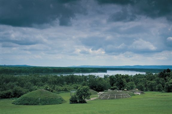
A view of the On-A-Slant Mandan Indian Village overlooking the Missouri River.
One Day My Sense Of Place Changed
A Look At A Major Historical Site
By Dakota Wind
MANDAN, N.D. - When I was growing up on the Standing Rock Sioux Indian Reservation I heard many of the negative typical commentary about General Custer.  I’d see t-shirts at the pow-wow stands of Yellow Hair with an arrow through this hat, with words like “Custer was Siouxed,” or variants of the theme of giving Custer an arrow shirt.  T-shirts like that can still be found on the pow-wow circuit throughout Indian Country, and whenever I see one, I can’t help but smirk and nod my head at the truth of it. 

Growing up in Fort Yates, there wasn’t much choice by way of food in town, either at the grocery store or in the commodity box.  Often enough, my grandparents and many people would drive to Bismarck or Mobridge to buy groceries for the week.  When we’d drive to Bismarck, we use to have to drive through Fort Abraham Lincoln State Park.  That’s back when ND HWY 1806 went through the park. 

When I was elementary school, I remember visiting the park twice, once in fourth grade and again in middle school.  This was before the reconstructed Custer House and other buildings that followed.  The only things I recall as as a little boy were the earthlodges of the On-A-Slant Mandan Indian village.  I recall how immense the earthlodges were and how they smelled like an old cellar.  There was no guide to tell us anything more about the history, archaeology, or culture of the park.  There was no ranger to monitor or secure the earthlodges or the blockhouses.  My earliest impression of the site wasn’t just the earthlodges’ size but the smell.  People, the general public, used them as restrooms.

When I was in high school, the Custer House, Granary, Commissary, and Central Barracks were being constructed.  I’d sit in the backseat and look out the window, sometimes I’d have my headphones on and I’d almost always be listening to Def Leppard, but when my grandparents were speaking, I’d be listening to them.  When we’d drive through the park, sometimes my grandmother would tell me about General Custer and how he’d taken an Indian woman, a Cheyenne maiden, how the soldiers took Indian women and had their way with them.  Sometimes my grandmother would even talk about her great-grandfather, one of Custer’s own men.  My grandfather never spoke of Custer or mentioned the soldiers, but I could tell by the set of his hands on the steering wheel as he gripped it, it provoked him. 

In high school, I joined the basketball team and sometimes we’d drive through Fort Abraham Lincoln State Park on the way to or from a game.   The coach was also an assistant in the school’s “Indian Club.”  He definitely had an opinion about the fort reconstructions and openly shared it with the team.  I felt ashamed that one of the soldiers was my ancestor and I heard a lot of things about the character of General Custer. 

One fall day, the history teacher, a burned-out recovering hippie of a woman with weary eyes and a tired cracked monotone voice to match (we called her “Beanie”) took the class on a tour of the reconstructed Custer House.  We were guided by a man portraying one of the General’s strikers.  He told us all about the virtues of General Custer, but we had our own opinion – at least I did – and I we quietly stepped through the house.  It was one-sided and uninviting.  Nothing the reenactor could say or do could make me or the class interested because what he said didn’t affect in any way our established opinion of General Custer. 

In 1908, President Theodore Roosevelt felt a sense of place about Fort Abraham Lincoln and General Custer, and he did something about it.  He signed the Fort Abraham Lincoln Act, deeding the old Fort Abraham Lincoln to the State Historical Society of North Dakota.  What’s Roosevelt’s connection? 

In 1877, Colonel Nelson Miles led the 7th Cavalry at the Battle of Bearpaw Mountain at the end of the Nez Perce Campaign.  On Oct. 5, 1877, Chief Joseph surrendered to Colonel Miles.  Miles was ordered to bring the Nez Perce to Fort Abraham Lincoln for internment, which he did and when he delivered the Nez Perce to Bismarck, ND, he took the first train to St. Paul, MN, to meet with Gen. Terry.  The colonel was promoted to Brigadier General. 

Brig. Gen. Miles went on to capture Geronimo and was promoted to Major.  Maj. Gen. Miles had a bit part to play in the events that led to Sitting Bull’s death.  Miles believed that the Lakota should have been firmly under control of the US Military not the agents of the Bureau of Indian Affairs.  Miles personally led the invasion of Cuba in the Spanish-American War of 1898.  Colonel Theodore Roosevelt led the 1st Volunteer Cavalry, popularly known as the Rough Riders, in the Kettle and San Juan charges. 

Aside from President Roosevelt’s contemporary relationship with Gen. Miles, Roosevelt was aware of General Custer’s association with the site, and the fact that Fort Abraham Lincoln was also a prison camp for the Nez Perce (only ten days; ten Nez Perce died during that time) and for the Grasshopper Band of the Northern Cheyenne in the winter of 1877-1878. 

President Roosevelt signed the Fort Abraham Lincoln Act to preserve and protect the history and culture of the site. 

My first experience of working at Fort Abraham Lincoln State Park visited me in the form of an elderly Mandan Indian woman.  She was dying of cancer and had asked one of her relatives, her children and grand children, to step forward to continue a native presence in the On-A-Slant Mandan Indian village.  When none came forward, she reached out and asked me.  But it isn’t as simple as that.  

She greeted me in Hidatsa in passing one day.  A few days went by, then she asked who I was (when a native elder asks that kind of question, it implies asking who I descend from, who my people are, and what my traditional name is).  Time passed and one day she called me “grandson” and asked me if I would work her ancestral village.  I said yes. 

The Mandan Indian people lived at this village, only they knew it as Watchman’s Village (it was later named the On-A-Slant Village by the Civilian Conservation Corps in the 1930s), and they lived there from about 1550 to 1781.  The Mandan Chief Four Bears’ father Good Boy called that village home.  The Mandan Chief Shehek Shote, White Wolf (called Sheheke or White Coyote by some) knew this village as his first home. 

In 1781, the Mandan were struck by an epidemic of smallpox.  They left their deceased loved ones in the lodges and abandoned the village in a move north to Knife River.  They never forgot where they came from.  There are still people at rest in the On-A-Slant Mandan Indian village. 

The Mandan, the Nu’Eta, have a sense of place about Fort Abraham Lincoln State Park.  Its home and its sacred. 

I had to learn more about Fort Abraham Lincoln State Park if I was going to work there, to make it matter to me, to establish my own sense of place. 

For the Lakota, there is the phrase, “My home is where I set my lodge.  One pole rests at the mouth of the Heart River…”  In 1803, the Hunkpapa Lakota and the Yanktonai Dakota engaged the Assiniboine and Mandan for control of this contested area and won in the Battle of Heart River.  For the Lakota, one pole of the lodge of the Teton lies in Fort Abraham Lincoln State Park.  For the Lakota, despite the connection the site holds with General Custer, Fort Abraham Lincoln State Park is home. 

For the Hunkpapa Lakota, there was a skirmish within the boundaries of Fort Abraham Lincoln State Park, a “Wood Cutter Fight.”  For the Lakota, battlefields are respected and honored because that’s where people died defending their way of life, their territory, even if they were the enemy.  For the Lakota, Fort Abraham Lincoln State Park is a memorial. 

In the fall of 1874, Lieutenant Tom Custer captured the Lakota war chief Rain-In-The-Face and imprisoned him in the Fort Lincoln guard house.  Two years before his arrest, Rain-In-The-Face conducted a successful horse-stealing raid on the Arikara at the Infantry Post.  He was arrested for killing surveyors on the Yellowstone Expedition of 1873.  Rain-In-The-Face might have been arrested and detained at Fort Abraham Lincoln but he was released in the dead of night in the late winter of 1874-75.  Rain-In-The-Face never spoke a word against Fort Abraham Lincoln and the only animosity he held was for Lieutenant Tom Custer. 

In May of 1875, General Custer hosted a ten-day celebration at Fort Abraham Lincoln in honor of the peace treaty he witnessed between the Arikara, Hidatsa, Mandan, Dakota and Lakota Indians.  At that very same celebration, General Custer heard testimony of the Indians about the mistreatment they were dealt at the hands of the Bureau of Indian Affairs Agents, and carefully recorded it.  In the fall of 1875, General Custer travelled east where in the spring of 1876, he testified to Congress on behalf of the American Indians and their plight, testified against President Grant and against the Secretary of the BIA.  He was arrested.  General Terry pressured President Grant to release him.  General Terry ordered General Custer to “use any means necessary” on the Centennial Campaign, the Little Bighorn campaign. 

The Lakota of the nineteenth century might not have liked the ideology of Manifest Destiny that gripped the United States, nor the fact that General Custer led his men in the field after he hosted them at his fort, but its history, and the Lakota respect what happened.  Sitting Bull himself offered that he would not speak ill against the dead, the enemy, out of respect. 

When I began my first summer at Fort Abraham Lincoln, it was with mixed feelings.  I’ve since learned all that I’ve written above, reader, and more.  My sense of place changed. 

I believe that history should be preserved, protected, promoted even, and I believe that it must and should be shared.  The history of Fort Abraham Lincoln State Park is a story about Indians, Indians fighting Indians, Indians fighting soldiers, a story about Dakota Territory, its what you might call an all American story. 

Reader, you may already have a sense of place about Fort Abraham Lincoln State Park or a sense of place of near you, you may not.  In the very least, I hope that I give you a moment to consider something about it.   

Monday, October 10, 2011

The Waterfall Maiden, A Lakota Love Story

The Waterfall Maiden
An Enduring Tale Of A Sad Love Story
By Dakota Wind
SIOUX FALLS, S.D. - The Ihanktowon, or Yankton, were camped at the falls of the Big Sioux River in South Dakota.  The falls was a favorite winter camp site as there was plenty of water, game, and resources for keeping the camp there. 

In the late fall and throughout the winter when the water was low enough, the Yankton could easily cross the river on stepping stones above the falls. 

Because this site was so popular, many tribes would trade here in an annual rendezvous. 

It happened one winter, at the time when winter passes and nature embraces spring, a neighboring tribe came to make temporary camp on the east bank of the Winding River.  The Yankton were camped on the west bank and as the seasons were changing, so did they begin to prepare to break camp.


The Yankton chief immediately formed a delegation of his head men, some of his relatives, and his own immediate family and crossed the Winding River Falls to meet their new neighbors. 

The new neighbors proved to be quite hospitable and gracious.  They put on a feast and dance for the Yankton and the celebration lasted into the evening.  The next day, the Yankton chief and his band readied themselves and broke camp, their destination: west to hunt and gather as their Teton Lakota relatives had always done. 

The evening before, during the festivities, the Yankton chief’s daughter met a young brave from the other tribe.  As her people began to prepare to leave their winter camp at the falls, she began to lose her motivation to break camp.  Her enthusiasm to leave waned, but she also didn’t want to disobey her parents and stay behind.  She broke camp with her people and left the winter camp behind. 


It was nearing the end of winter.  The time of year when the geese return, when bison calves are born, when trees began to leave, and it is also the time when ice breaks. 

It was late winter, or early spring if you see it that way, and as her people’s band moved further and further away from the Winding River Falls, the chief’s daughter became withdrawn and sad.  The Yankton maiden became so overcome with longing that she left her father and people and stealthily made her return to the falls. 

Okay, so I couldn't find a proper appropriate image of a native woman by a waterfall, and, "No. Native women didn't dress like this.  If they did, I wonder why I didn't see a sight like this back on the rez."

During the ensuing days from when her people initially left their winter camp to her arrival, the snow melted and the ice broke, submerging the stepping stones of the Winding River Falls.  She couldn’t cross the river.  She stood at the edge of the river looking at the neighboring tribe’s abandoned campsite. 

The Yankton Chief noticed the absence of his daughter sometime later and he knew just where she might be bound, so he sent some of his scouts back to the winter campsite to retrieve her. 

The scouts came upon the Yankton maiden, and as they came closer they overheard the maiden’s song. 

As she stood there, a melody from the falls came to her.  With this melody, she put the words that the young brave had spoken to her: 

One of William Horncloud's albums.  Gratify yourself and get a copy today.

Nióiye wéksuye,
Nióiye wéksuye,
Nióiye wéksuyiŋ na wačhéye nióiye wéksuyiŋ na wačhéye. 
“Eháŋni šáš kičhí waúŋ šni,”
ečháŋmi kiŋ óta ye nióiye wéksuyiŋ na wačhéye. 

I regretted losing you (I wanted you back) and I was heart broken many times. You live somewhere else and are having a hard time.

When you quit (that one) you and I will live together. 

Why did you tell about us?  And now I am in misery, I am in misery.  Why did you tell about us?  And now I am in misery.  

If this is not possible on earth, it will be possible in heaven.  

Love me, you made me miserable.

I remember your words,  
I remember your words,
I remember your words and cried.  
I remember your words and cried.  Many times I have thought:
“I should have been with her long ago,”
I remember your words and cried.   

The song, adapted to flute by Kevin Locke, appears on Locke's album "Dream Catcher."  You should go get yourself a copy of this one too.  Kevin is teaching me this song and has permitted me to play it, which I will when I'm confident I sound good.

Song by William Horncloud
Story by Ben Black Bear Sr.
Big Sioux River name, Ipákšaŋkšaŋ Wakpá (Winding River) remembered by Agnes Ross
Adapted to flute by Kevin Locke


Thursday, September 22, 2011

Lodge of the Blacktailed Deer and Camp Greene

Looking west across the Missouri River valley I can see the block houses, on a higher resolution of this picture (for I can't upload a higher one on here) and in another picture, I can actually see the Council Lodge of the On-A-Slant Mandan Indian Village. 
Lodge Of The Blacktailed Deer And Camp Greene
North Dakota Landmarks You Must Visit
By Dakota Wind
GREAT PLAINS - Lately, as I’ve been making the drive to work in Bismarck, Fort Abraham Lincoln State Park, the greatest park in North Dakota, has been drawing my eye.  I can see it across the Missouri River from where I park my car.  I can also see the profile of Little Heart Butte on the far horizon, standing boldly as a long-forgotten sentry watching the river and the plains.  Sometimes when I’m driving out to the University of Mary another land feature that grabs my eye is the Mandan Site, a butte known to the Nu’Eta as the “Lodge of the Black Tailed Deer.”

This picture of Keith Bear was taken on the Fort Berthold Indian Reservation, home of the Arikara, Hidatsa, and Mandan Indians (also known as the Three Affiliated Tribes).  Herb Ascherman, Photographer.  www.ascherman.com

The Lodge of the Black Tailed Deer is where the Mandan, the Nu’Eta, say they came up into the world.  I heard the story from traditional storyteller and flute-player (and flute-maker) Keith Bear, and I’ll sum it up for you here:

A long time ago, the Nu’Eta lived under the earth.  They didn’t know about the sun, the moon, the stars, or the blue sky at that time.  Then came a day when some Nu’Eta hunters came to a large root (grapevine root or prairie turnip root depending on who you hear the story from) and decided to climb it after noticing a shaft of sunlight pierce the shadow.  The hunters climbed the root to the top and saw for themselves, ganges of bison, herds of deer, elk, and antelope, and saw how the sunlight played upon the Missouri River.  They saw grass swaying in the wind and felt the breeze for themselves.  The hunters descended the vine and returned to their village to share what they saw.  The Nu’Eta decided that they would go to the surface to live there.  The hunters returned to the root and the people began to carefully climb it.  They say that a pregnant woman, heavy with child, was in a hurry to bear her baby in the new world, and she began to climb the root regardless of the warnings the people shouted at her that few climb it at a time.  When she got halfway up the root, it came loose and snapped, dropping her back to the people below.  Some of the Mandan, the Nu’Eta, made it to the surface.  The Nu’Eta say that there are still people waiting to come out of the earth. 

The butte mentioned in the story above is pictured here, on the west bank of the Missouri River, south and west of the University of Mary.  It is the dark pyramidal shape in about the middle of this picture.  The cottonwood forest on the floodplain below is thick.  With autumn on the land, the leaves are turning brown and will eventually be a brilliant yellow. 

The butte Lodge of the Black Tailed Deer is called that only when talking about the origins of the Nu’Eta.  It is called Eagle Nose Point, or Bird’s Bill Point, when talking about the temporary village of discontented Nu’Eta who lived there to work out their angst.  Ensign Nathaniel Pryor mentioned encountering such a group of Nu’Eta discontents while bringing the Mandan Chief Shehek Shote back to the Mandan from his three-year odyssey to meet President Jefferson in 1809. 

The butte is known by still another name in relation to the name of the bottomlands that settlers bestowed upon it: Sugarloaf Butte. 

There is nothing left of Camp Greene, at least nothing remains of the camp that you'd see today.  There is a darker "patch" of trees in about the middle of this image, on the other side of the Missouri River.  This photo was taken at the Annunciation Monestary near the University of Mary looking west across the Missouri River. 

North of the butte, but south of Fort Abraham Lincoln State Park, the greatest park in North Dakota, is the site of Camp Greene. 

Brevet Brigadier General Oliver Davis Greene pictured here as a second lieutenant. 

Camp Greene was established in April 1872 at the mouth of the Little Heart River as a military supply station for the protection of the Northern Pacific Rail Road survey crew preparing to head west for Yellowstone country.  Co. K of the 17th Infantry commanded by Lieutenant OD Greene came up on detached service from Fort Rice.  Originally, Camp Greene was to become a permanent post.  Three months later, the garrison was withdrawn and stationed on a bluff overlooking the Heart River to establish Fort McKeen.   

Greene’s story is an interesting one too.  He was brevetted four times throughout the Civil War and eventually became Brevet Brigadier General Oliver Davis Greene.  Greene served in the Maryland Campaign of 1862.  At Antietam, Greene kept form of his command under fire and became a Medal of Honor recipient.  Like most officers after the war he was taken back down to regular army rank, for Greene that meant being a lieutenant.  Greene retired in 1897 with the regular army rank of colonel. 

Friday, September 16, 2011

A View of Fort Yates

I stood on top of my car and took pictures of Fort Yates.  The very left of the image above is my perspective looking east, the center is my perspective looking south, and the right is my perspective looking west.  In this composite diaramic image of Fort Yates, one can see the Standing Rock Administrative Office, the last remaining building of the old Fort Yates, Sitting Bull's gravesite (in the frame left of center), the plateaus to the south of Fort Yates, Sitting Bull College, and the Standing Rock Community High School (in the right-most frame). 
A View Of Fort Yates, N.D.
Long Soldier District, Standing Rock
By Dakota Wind
FORT YATES, N.D. - So this past summer I went down to Fort Yates, on the Standing Rock Sioux Indian Reservation, where I was born and raised.  As a boy I knew Fort Yates as an island in the middle of the Missouri River, and it is, with only a mile long cosway going to the mainland.  Then North Dakota was struck with a prolonged drought and gradually the Missouri River, the very lake in which Fort Yates rests, Lake Oahe, began to dwindle until it was as a stream one could step over.  In the past few years, increased rainfall and snowfall swelled the tributaries of the Missouri River and made Fort Yates an island once again. 

The city of Fort Yates has a lot of history to it.  Over three hundred years ago, the Cheyenne Indians lived there in an earth lodge village, and referred to Golf Hill (the hill on which I took this picture; which is also surrounded by water) as the Hill That Stands Alone.  The Cheyenne lived there until the arrival of Lewis and Clark in 1804.  They abandoned the earth lodge culture and took up the tipi and horse culture. 

This is Fort Yates at the turn of 1900, taken by Frank Fiske.

As a military fort, it was established in 1863 as the Standing Rock Cantonment.  It was also called Standing Rock Agency.  The fort’s business was to oversee the Hunkpapa Lakota, the Sihasapa (Blackfeet) Lakota, and the Pabaska Ihanktowana (Cuthead Band of the Upper Yanktonai).  The fort served as the seat of authority for the US Indian Agent, of which Major James McLaughlin is the most well-known agent. 

This is the last remaining building of old Fort Yates. The building served many purposes over the course of the years, including a stockade. My great-grandfather, Francis Winters, told me he once stole a pig from a local farmer. He was thrown in the stockade overnight.

The Standing Rock Cantonment was renamed in 1878 to Fort Yates in honor of Captain George Yates who was killed at the Battle of the Little Bighorn.  The fort was decommissioned in 1903.  There is only one building remaining from the military fort. 


The lake which surrounds Fort Yates is Lake Oahe (pronounced Oh-AH-hay).  In the 1950s, the US Army Corps of Engineers built a dam above the city of Pierre, South Dakota.  The dam system was built primarily to control the annual flooding of the Missouri River.  The dam created a man-made lake that reached from Pierre, South Dakota to Fort Rice, North Dakota.  The lake is named for the Oahe Indian Mission, which is located about eight miles upstream of the Oahe Dam.  Oahe means “Something to Stand On,” as in the foundation of a building.


In December, 1890, Major McLaughlin ordered the Bureau of Indian Affairs police to arrest Sitting Bull.  It was a scary time for everyone, settlers and native alike, with the new statehood of North Dakota and South Dakota and the arrival of the Ghost Dance to Standing Rock.  The Ghost Dance was based heavily on the Christian religion, and testified that the eminent second coming of Jesus Christ was soon, but would save only His red children and make the world new again, and bring back the bison. 

I remember as a boy seeing tour buses stop here to pay their respects to Sitting Bull. 

Sitting Bull wasn’t a Ghost Dancer, but he was arrested to pacify the fears of new Sioux Outbreak.  After Sitting Bull was killed, his body was placed in a coffin made by the fort’s carpenter and he was buried right outside of Fort Yates. 

The Arikara Indians and Cheyene Indians also have a legend of Standing Rock.  It is my opinion that it was a Yanktonai Dakota brave who had an Arikara wife and a Cheyenne wife.  The each spoke a different language and came from different cultures.  The three different legends all end in the woman turning to stone. 

In front of the Standing Rock Tribal Administration office is the namesake of Standing Rock.  Resting on a brick pedestal is the original Standing Rock, a memorial of a woman whom as legend says turned to stone.  The story goes, that a long time ago, a Yanktonai man took a second wife.  The first wife, feeling ill about the arrangement, refused to move when camp was struck.  She stayed behind with her baby on her back.  Later that day, the husband noticed that his first wife was missing and sent his brothers to backtrack and find her.  When they saw her, they called out to her, and she didn’t respond or move.  As they walked closer to her they continued to call out to her.  As they finally stepped up to her, they beheld a stone standing upright where they left her.  According to the John K. Bear, this happened in 1740 along what is called today, Stone Idol Creek, located off the Cannonball River on the Standing Rock Sioux Indian Reservation.

Friday, September 9, 2011

A Visit to Fort Abraham Lincoln

A Visit to Fort Abraham Lincoln

Military History Explored At Historic Site
By Dakota Wind
MANDAN, N.D. - Fort McKeen, infantry post, was established in June, 1872. Companies “B” and “C” of the 6th Infantry and a detachment of Arikara US Indian Scouts under the command of Lieutenant Colonel Daniel Huston were the first to occupy what one year later became Fort Abraham Lincoln.

Fort McKeen was named in the tradition of the day, that is, named in honor of someone really important in the military or politics.  This particular fort was named to commemorate Colonel H. Boyd McKeen who led the 81st Pennsylvania Volunteers.  Colonel McKeen lost his life at the Battle of Cold Harbor in the Civil War. 


Fort McKeen was established to protect the Northern Pacific Railway survey line as it went west into Yellowstone country.  The infantry discovered that the Indians had horses, and further, that the Indians didn’t have the patience to wait for soldiers on foot to catch up to them. 

Of course, long before Fort McKeen was established, and before the Mandan Indians constructed their first earthlodge below the bluff, but above the floodplain, this particular site was probably regarded with reverence.  Near the blockhouse furthest away in the first picture of this article is the remains of one earth mound from the Late Woodlands Culture. 

It is clear that this site has been continuously culturally occupied for the past two thousand years, first by the earth mound culture, then the earth lodge culture, and later by the US military. 


Near the Fort Abraham Lincoln State Park museum, is a Corps of Discovery II medallion embedded in a concrete pillar. The medallion commemorates the 200th anniversary of the Corps of Discovery, also known as the Lewis and Clark Expedition.

I’ve seen for myself, hard core “Lewis and Clarkers” stop here and at the Lewis and Clark Overlook north of the Mandan Indian village, to read passages from Lewis and Clark’s journals on the day Lewis and Clark stopped there.  It is almost like a religious pilgrimage. 


Of course, Fort Abraham Lincoln State Park, the greatest park in North Dakota, is named for the fort, and is known more for it’s association as being the home of General Custer’s last command and his trail to the Little Bighorn than for being named for President Abraham Lincoln (it was named in honor of the 16th US President about eight years after his death).

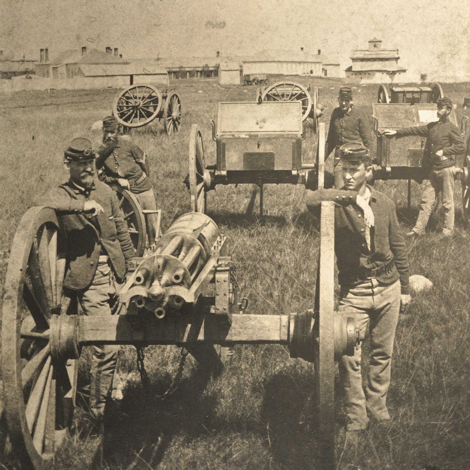
It was determined that the infantry wasn’t the right kind of soldier to protect the Northern Pacific survey line, so Congress established Fort Abraham Lincoln in March of 1873. The fort was home to six companies of the 7th Cavalry. General Custer was stationed here from 1873 to his death at the Battle of the Little Bighorn in 1876.


In 1873, General Custer led his command to the Yellowstone to provide protection to the survey crews from various Sioux attacks. 


In 1874, General Custer led his command to the Black Hills to confirm the discovery of gold. 

The meanings of building forts in the American west weren’t articulated very well to the Indians or the settlers.  For American Indians, forts were a sign of an encroaching domineering society.  Fort settlers, forts meant protection from Indians.  In hindsight, it is easy to say and agree that forts symbolized the Manifest Destiny policy of the day.  A little more difficult to see is the fact that forts didn’t provide protection to settlers at all. 

In Libby Custer’s “Boots and Saddles,” she describes the scene about an old man visiting with her husband.  The general repeatedly warned him not to “squat” on the west bank; the old man did anyway and was killed by “wild Indians.”  The Bismarck Tribune ran a story about the inaction of General Custer and the fort, settlers were angry and scared, but the fort and the soldiers there were not there to protect settlers. 


Getting back to what you’ll see at Fort Abraham Lincoln today is a reconstruction of the commanding officer’s quarters as General Custer and his wife would have known it in 1875.  My friend and former co-worker, First Sergeant Al Johnson, greets visitors here regularly each summer.


Al’s been living in 1875 since 1995. He’s the face of Fort Abraham Lincoln.

Throughout the house, you’ll see furnishings from the late 19th century to the turn of the century. Really important stuff, like things actually owned by General Custer and his beloved Libby the living history guide will point out to visitors by saying the magic words, “Take special notice of…” That is your cue to express your deepest admiration for the appointed item in the forms of “oohs” and “aahs.” An occasional feigned yawn or laborious stretch and a murmur about the general’s taste works here too.


Take special notice of the burgundy drapes. 


Take special notice of the silverware. 


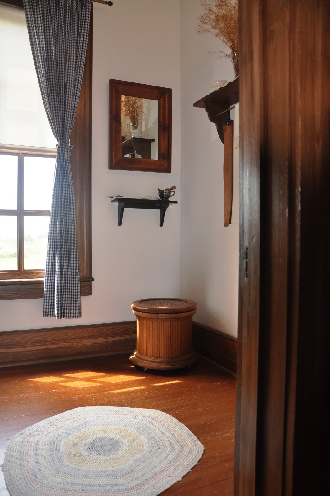
You don’t have to take special notice of this commode, but one day someone in a largish group was immediately seized with a sour gut and left a rather unpleasant gift for the next visitors to tour the house. The stench was so pungent and strong and wafted out into the hallway in waves of such sour putrescence one could but barely choke back gags with polite coughs. I share the story here only to notify you dear reader to pay a visit to the latrine and leave your presents there. 


Take special notice of the turkey platter. 


The cellar.  At one point, General Custer kept a bobcat and a porcupine he acquired on the Yellowstone Expedition down there as pets, until he donated them to the University of New York, if I recall correctly.  The brickwork is from the very first house. 


This drawer and mirror piece was part of General Custer’s and his wife’s personal belongings. 


This little marble top table goes with the drawer. 


These two chairs were once owned by General Custer.  I’m sure that they weren’t artfully arranged for people to look at but used, probably in the study. 


This campaign desk was with General Custer throughout the Civil War, his campaign against the KKK in Louisiana after the Civil War, the Indian Wars, and on the Centennial Campaign or the Little Bighorn Campaign of 1876.  One time a person on tour actually broke down and cried after hearing about the background of this desk. 


The green cloth bound book titled “Life of Daniel Webster” was given to General Custer by his good friend Lawrence Barrett, a famous Shakespearean actor in New York in the 1870s.  General Custer saw Barrett in Hamlet over a dozen times. According to Libby Custer, he watched it with as much attention and zeal as seeing it the first time every time. 


If you are so lucky and have the time, First Sergeant Johnson or other guide, can handle the book and show visitors the dedication from Barrett to Custer.  The inscription reads, “To. my dear Friend G. A. Custer – from Lawrence Barrett feb 17th 1874.” 


Libby’s rocking chair in the main bedroom. 


The only other thing that was actually owned by the Custers is the map case on display in the Commissary.  The little brass placard on the glass reads, “GA CUSTER’S MAP CASE Libby’s only memento from The Little Bighorn on loan from the trust of Stephen Ronald Cloud Jr. and Ryan John Cloud.”  A notarized document testifying the line of ownership back to General Custer has been taped on to the map case. 

Thank you to Fort Abraham Lincoln State Park, the greatest park in North Dakota, and First Sergeant Al Johnson, the face of Fort Abraham Lincoln.