Showing posts with label Battle. Show all posts

Saturday, October 21, 2017

Terrible Justice, A Book Review

Whitestone Hill, this image appeared in Harper's Weekly, based on a pencil drawing by Gen. Alfred Sully. 
Terrible Justice, A Book Review
No Detail Too Grim Left Out
By Dakota Wind
Chaky, Doreen. Terrible Justice: Sioux Chiefs and U.S. Soldiers on the Upper Missouri, 1854-1868. Norman, OK: University of Oklahoma Press. 2012. $39.95 (hardcover). 408 pages. Illustrations, maps, photographs, bibliography, and index.

Chaky’s Terrible Justice begins with the Ash Hollow conflict of 1854, as settlers migrated across the Great Plains to better lives on the west coast or in the Rocky Mountains. Her research was sparked after participating in an archaeological survey at Fort Rice, and she soon realized that as much as the story of adventure belonged to the soldiers, it was a story that ultimately belongs to the Sioux. She was not satisfied that so little was published about the military’s role in Manifest Destiny there at Fort Rice and across the plains.

An example of an outstanding feature in Terrible Justice is Chaky’s use of Little Crow’s actual name, which is Taóyate Dúta (His Red Nation), and her continued use of his real name throughout her book. She doesn’t mince words in her description of the punitive military campaigns – Generals Sibley and Sully were sent to make war, take prisoners, destroy food resources, and secure Dakota Territory for white settlement.

Chaky carefully constructs the 1863 Sibley campaign on the orders of General Pope and his orders to secure Dakota Territory from President Abraham Lincoln. Sibley’s march is an invasion, and the conflict between the Očhéthi Šakówiŋ (the Great Sioux Nation) and Sibley's command began when his campaign left from Camp Pope on the Minnesota River, not when a young man from the band of Íŋkpaduta (Scarlet Point) shot and killed Surgeon Weiser.

Terrible Justice isn’t an apologist’s narrative. Chaky describes in great detail the gory violence and destruction committed by men, native and non-native; scalps taken by soldiers and warriors. But, she draws close when she includes brief remembrances of Pvt. Phebus, Sgt. Martin, and acting Gov. Hutchinson, several years after the Whitestone Hill massacre.

Federal “Indian Policy” has always been one of dispossession and displacement. As settlers advanced west into Indian Country, tensions erupted in an escalating conflict until the military came in to secure the peace by forcing first nations to sign treaties (land cessions and reservations). Treaties were generally signed by a majority of grown men, sometimes not even by that (ex. Treaty of New Echota).

The Sibley-Sully campaigns were pre-emptive. The Yanktonai, who, at that time yet lived in their homeland, were killed, imprisoned, and forced west across the Missouri River without ever signing a treaty to cede their lands. The land between the Missouri River and the James River is still unceded Yanktonai territory.

Chaky signed my copy, “Dakota, I hope I’ve represented the Sioux properly with this book. I enjoyed doing it very much. Doreen Chaky, 7/28/13.” It’s a book that’s not hard to read, but it’s straight content and elaborate description make it hard to read. These are my people. Chaky began her narrative that this was “the story of the Sioux.” A quick review of her bibliography reveals six recognizable works by first nations, and one hopes a second edition of Terrible Justice would draw on more the surviving oral tradition. 

Recognizing that there are many, many books available for purchase on the subject of the Little Bighorn conflict, Chaky brings her work to a tidy close, by barely mentioning that fight (one sentence). Wounded Knee receives no mention. That’s all right, not every history book about the Očhéthi Šakówiŋ needs to include that tragedy. Chaky focuses on the conditions of peoples, native and settler, of the Great Plains. 

It's a good book. Go get yourself a copy. The maps are a great visual aid.

Dakota Wind is an enrolled member of the Standing Rock Sioux Tribe. He is currently a university student working on a degree in History with a focus on American Indian and Western History. He maintains the history website The First Scout.


Monday, March 3, 2014

Battle Of The Buttes: Warfare At Saddle Butte


Photo of Saddle Butte, near present-day Stanley, ND, by bobneugenbauer.
Battle Of The Buttes
Warfare At Saddle Butte

As told to Colonel A.B. Welch, edited by Dakota Wind
BISMARCK, N.D. - In the summer of 1860, a war party of six Dakȟóta warriors advanced into Kȟaŋğí (Crow) country for the purpose of obtaining satisfaction for the death of a relative of the leader of the band. Having been successful in their undertaking and provided with fresh horses, they left the Heȟáka Wakpá (Elk River; Yellowstone River) and cut across to the Makȟóšiča (Bad Lands) of the Heȟáka Tȟa Wakpá (River Of Elk; Little Missouri River) and the intention of striking the head of Ožáte Wakpá (Branching River; Knife River) and following its course to the villages of the Pȟaláni (Arikara), where they expected to trade for some corn from these Indians; then sell their otter skins which they had secured from the Kȟaŋğí, at Fort Berthold trading post at Fish Hook Ford, for powder and lead, and pass into the country of their relatives, the Iháŋktĥuŋwaŋna Dakȟóta (Yanktonai Dakota), on the east banks of the Mní Šošé (Water-Astir; Missouri River). But their plans miscarried and, with the souls of explorers, they had held to the Heȟáka Tȟa Wakpá and, in December, had struck the great Mní Šošé at a point a few miles north of the confluence of these two streams. They had purposely avoided the mouth of the stream for, at that day, it was a favorite camping place of the Miwátani (Mandan).


Map of the region from Fort Berthold to the Grand River Agency, 1873.

Three and a half miles north of the Heȟáka Tȟa Wakpá is a commanding elevation which, by its peculiar shape, has always been known as Pahá Čháŋwak’iŋ (Lit. Saddle Butte/s). A half mile south of that butte is another one which is very steep and difficult to ascend and the summit is a perfectly flat area of perhaps two acres. Across the Mní Šošé from these buttes, and nestling among the brushy trees along the banks of a small stream called Mnitáŋ Wakpá (Lit. Flood Creek/Rising Water Creek; possibly Deep Water Creek), was a temporary winter hunting camp of Miwátani, Ȟewáktokta (Hidatsa) and Pȟaláni, who had come up from their comfortable round dirt lodges at Fish Hook Village, to lay in a stock of meat and skins. A few friendly Hóhe (Assiniboine) were camping with them.


Like A Fishhook Village, as portrayed by Martin Bearsarm.

From the heights of the buttes on the western shore, the Dakȟóta scouts located the horses of their old-time enemies, and the band decided that they needed a few new horses to take home for the gift-giving dances which would take place upon their triumphant arrival at the thiyóšpaye (band) of their people along the Pȟaláni Wakpá (Arikara River; Grand River). Their plan was to cross the thin ice after dark and work the herd easily away, if the herd guards were not present. However, if an alarm were made, they would stampede the horses at once toward the east and keep them pounding straight in that direction until morning, when they would turn south and finally cross the Mní Šošé in the vicinity of the mouth of the Iŋyaŋ Wakağapi Wakpá (Lit. Stone Statue River; Cannonball River).


They reasoned that the villagers, not knowing the Dakȟóta strength, would hesitate to follow them during the night and, before their signs of approach could be made out in the morning, the herd would have such a start that they could not be overtaken. Not being able to cross their own mounts on the ice, it was decided that they would enter the camp and secure horses from among the lodges, where they would be tied or hobbled and held ready for the next day’s hunting.


Karl Bodmer painted this scene of Mandan Indians crossing a frozen Missouri River.

The weather turned very cold in the evening and the members of the little party shivered around their small fire behind the butte during the afternoon and waited for the night to come. The fact that they had but a few rounds of ammunition for their heavy Sharps rifles and Springfield carbines, did not cause them much concern, for they did not anticipate fighting unless they were discovered by some late stroller when they were among the lodges after riding horses, in which case they expected to take coup, grab horses and, riding into the herd, stampede them by the waving of blankets and firing. The dark would veil their movements. At any rate, they were brave men and had been against the Kȟaŋğí, who were greater warriors than these village corn-eaters, whom they held in much contempt. They had struck terror to the hearts of the Kȟaŋğí and they would succeed in this small affair against these people who lived in dirt houses and looked to tall pickets for protection rather than fighting.

When the low circling sun had settled below Makȟóšiča, darkness descended quickly and the six Dakȟóta crossed the ice without difficulty and approach the camp. But sharp eyes had noted their every movement as they boldly passed in among the scattered lodges. A woman or two walked among the shelters and sounds of a drum and dance songs came from one of the largest of them where the Miwátani were feasting. Several horses were standing in a group before a large buffalo tipi and towards these, the scouts advanced. But even as the audacious Thítȟuŋwaŋ [1] stopped to loosen the thongs by which the horses were attached to their picket pins, a wild yell and a shot was heard, and the lodges appeared to pour out armed men by the score.

Tȟašúŋke Kȟokípopi [2] (His Horses Cause Fear), who was the leader of the party, at once started firing into the mass of advancing villagers and yelled to his men to get the horses loose. But the knots were secure and, before they had time to slash the tough raw hide open, the crowd was upon them and they were compelled to retire or be overwhelmed. Shooting their way through the circle, they leapt into the tangled brush where pursuit was difficult and retraced their trail of approach where they reached the river bank without the loss of a single man.

Their only safety now lay in getting across the river ice and gaining the western shore, before the pursuit became too close, from which place they could prevent their enemies from crossing after them. A few rifle bullets slashed the ice as they safely made the crossing, but to their great surprise their pursuers made no attempt to follow. This puzzled the Dakȟóta and caused them some uneasiness as they huddled around the embers of their old camp fire. The attempt to steal the enemy’s horses had failed, so they decided to follow the Mní Šošé down to the entrance of the Heȟáka Tȟa Wakpá and then enter Makȟóšiča south of that stream, where game was plentiful and cover in the gorges was easily found and pursuit would be very difficult even if the enemy followed in force.

Theodore Roosevelt National Park in winter by Scott Thomas.

Meanwhile, a body of their enemies, consisting of about thirty Miwátani under the leadership of Red Star, a war chief, moved rapidly toward the south along the shores of the Mní Šošé for several miles and then crossed the ice to the western bank and, turning north, strung out along the banks of the Heȟáka Tȟa Wakpá where they maintained a close watch and waited for the day. Another band, made up of Pȟaláni under Sitting Wolf, also crossed the river and took up a position in the hills to the west of the Dakȟóta, and a strong force of Ȟewáktokta with Lean Bull at their head, and strengthened by a half-blood named Powder Horn (His French name was Packineau), with a mixed body of Hóhe and others from the camp, filtered across the ice during the night and stayed close under the banks until daylight came. The six Dakȟóta were completely surrounded.

Having recovered the horses which they had abandoned on the west shore, the Dakȟóta were led out of their uncomfortable camp before sun up by Tȟašúŋke Kȟokípopi, keeping some distance back from the river in the hills. Sensing danger at the Heȟáka Tȟa Wakpá, Kȟaŋğí Hó Wakȟáŋ [3] (Holy Voice Crow) was sent forward to scout out a safe place for the crossing and, as he cautiously approached, he was met by a flight of arrows from Red Star’s men, who crossed the river at once and started in pursuit of him. Signal yells were answered from all sides and Kȟaŋğí Hó Wakȟáŋ lost no time in rejoining his comrades. It became apparent to the Dakȟóta that they were in the middle of the circle of advancing warriors and that their chances of cutting through in safety to the rough country were small. They decided to make an effort to gain the butte behind which they had spent the night and there make their supreme effort. Owing to the cautious advance of the enemy, they did finally reach the foot of this steep-sided, flat-topped butte without any loss.

Keeping under cover of the piled-up masses of sandstone which had fallen from the outjutting [sic] strata which covered the summit, the Dakȟóta managed to kill several of their pursuers and finally reached a point directly under the projecting sandstone cap. To find a crack up which they night crawl to the summit, before the enemy could reach the top from the other side, became their problem and, in doing this, it became necessary to expose themselves to fire from below.

Another photo of Saddle Butte, near present-day Stanley, ND, by bobneugenbauer.

In so doing, Tȟašúŋke Kȟokípopi was shot dead and his body slid down until it was caught and held by some sprawling mountain cedar. White Horse, the Pȟaláni who had made the kill, sprang up the rocky steep to strike the body and complete the coup and was almost within reach of the dead man, when Wahíŋkpe Uŋ Ópi [4] (Wounded With Arrows) jumped from behind a rock and, with his rifle touching the surprised and dumbfounded Pȟaláni, fired his last remaining shot.

The rush of the Dakȟóta to gain control of the summit had succeeded with the lost of but one man, and they yelled with derision at their enemies and dared them to come and take them. The northern Indians were seen to carry several bodies away during the day, and an effort was made in the afternoon to rush the Dakȟóta from all directions at once. But this was costly. The attackers were only too glad to retire before the heavy Sharps and Springfields of the men on the butte, and a number of me were carried across the ice to the village, but whether dead or wounded, the Dakȟóta could not tell from their position. The affair settled down to a siege; the Dakȟóta were out of rifle ammunition and had nothing left except their clubs and bows and a few arrows, then they began to feel the effects of hunger and thirst and cold. They saw meat brought from the village to the several camp fires of the men on guard and the distressed Dakȟóta were taunted by the tȟóka (enemy/enemies) below with songs of victory and yells of vengeance.

Late winter in the Badlands, along the Little Missouri River near Watford City, ND. Photo by Dennis Rosenkranz, USGS.

As the sun went down, the stinging cold of the night chilled the Dakȟóta upon the butte and the air became filled with fine snow, which was flung winds which swept the high place into the faces of the worried men and added much to their discomfort and dismay. A council was held and the five men decided that the only hope of escape was to make an attempt to break through the ring of tȟóka below. While it was true that their enemies could not reach them, the brave Dakȟóta decided to fight them below; they would carry the fight to them; if they should escape they could join their friends and relatives in the Dakȟóta camps; if they died, their people would sing of their bravery and the story of their heroic death would be told by the evening fires.

The men who gathered about the little fires in the middle of the night among the trees and rough lands dozed with their buffalo robes drawn closely about them and their heads upon their knees, but sprung to their feet by the whispered caution of the sentinels. Something strange was taking place upon the butte. An unseen Dakȟóta was singing his death song and as the song of death was carried to their ears by the shifting winds of the storm, it brought to them a sense of mysterious and intangible fear of the super-natural, and of the possible failure of their own “medicine.” But the strange Dakȟóta song was soon forgotten as old Black Bear, the Ȟewáktokta Medicine Man, began some ceremonies and the men danced and sang in honor of the Pȟaláni, Miwátani and Ȟewáktokta warriors who had met death that day.

The long, cold night was nearly ended; the east was turning grey and the neighing of the horses on the opposite shore could be plainly heard as they were being driven down by the young boys of the camp to the holes in the ice for water; many of the waiting tȟóka below the butte had gathered in a body in a place at the foot of the hill. Nothing had been heard of the Dakȟóta for some time and the allies were debating about sending men to scout out the condition of affairs upon the top of the butte, when they were suddenly startled by the yells of the Dakȟóta warriors and by the sight of them hurling themselves over the edge of the high hill.

"Winter Village Of The Minatarres," by Karl Bodmer.

They leapt from the flat top to the icy sides and slid and tumbled to the very center of the amazed tȟóka. So suddenly had this even taken place that those desperate warriors killed many of them before the tȟóka had sufficiently recovered from their consternation to defend themselves. Then they swarmed to the attack and, in a few minutes, Čhaŋȟpí Sápa (Black Tomahawk) and Travelling All Over Warrior [5] were overwhelmed and killed, but a number of tȟóka also lay dead in the trampled snow to show with what fury these two Dakȟóta had fought. Kȟaŋğí Hó Wakȟáŋ and Tȟatȟáŋka Nážiŋ [6] (Standing Bull) were engaged in a terrific hand to hand combat with so many Pȟaláni and Miwátani that the tȟóka dared not use firearms against them for fear of killing their own men. The stone clubs of the Dakȟóta were used with terrible effect, but against such heavy odds they could not hope to win through and Tȟatȟáŋka Nážiŋ soon died from a blow with the butt of a rifle.

As many of the tȟóka crowded to make coup upon the body of the dead Dakȟóta, Kȟaŋğí Hó Wakȟáŋ managed to break through them and sprung for the shelter of the timber. But he soon met other Miwátani coming in from the night fires a short distance away and died in a whirl of blows by clubs and knives, his death song ringing clear and loud upon the crisp, cold morning air.

The villagers subjected the bodies of these brave men to every indignity and, in their rage at losing so many men, cut and slashed the bodies in a frightful manner. The storm, which had lulled during the early morning hours, however, now arose to such fury that they were compelled to straggle across the ice to their camps for protection as well as to attend to their own serious wounds, which were many. The tȟóka were given over to mourning and grief and for once, the scalp dance of the women was not accompanied by the boastful stories of the warriors, and the victory had been purchased at so great a sacrifice in dead and wounded that no one had the audacity to propose a new name for anyone. The wailing of the grief-stricken women, who had cut off their hair and slashed their arms and breasts in token of the loss of their dead men and sons, was heard in their camp for many days. The white traders at Fort Berthold sold every white sheet and blanket they had, and the white-robed figures of those who mourned had not been so numerous since the great battle between the Pȟaláni and Thítȟuŋwaŋ [7], which had caused the Arikara to go to live with their friends, the Miwátani and Ȟewáktokta at Berthold.

A section of the Sitting Rabbit (Mandan) map of the Missouri River. This screen capture is of the map where the Little Missouri River converges with the Missouri River. Saddle Butte appears on this map.

During this short, fierce battle at the foot of the icy slopes of the butte, none of the villages had noticed that only five Dakȟóta were accounted for. It is possible that they thought that one had escaped. But the sixth Dakȟóta had met with a remarkable adventure and one which saved him from the fury of the tȟóka.

When the desperate Dakȟóta had taken the leap from the rim of the butte, Wahíŋkpe Uŋ Ópi, a Húŋkpathi Iháŋktĥuŋwaŋna Dakȟóta (Lower Yanktonai Dakota), had charged with the others. But some snow had drifted across a wide crack and, giving way as his weight struck it, he had fallen into a cave-like recess and struck his head heavily against a stone, for the day was ended and night arrived when he regained sufficient consciousness and strength to enable him to struggle to the surface of the ice field.

From the camp across the river came the sound of victory and celebration, and the wailing of the bereaved women. Wahíŋkpe Uŋ Ópi picked his way to the bottom and searched the bloody, trampled snow for the bodies of his comrades. The signs of a terrible combat were very plain and he counted the bodies of twenty-one tȟóka, scattered in the vicinity, before he succeeded in locating his four friends who had died there. Their bodies were all terribly slashed and unrecognizable from the mutilation they had received, except by the breech clothes they wore around their loins, and their moccasins. The body of Kȟaŋğí Hó Wakȟáŋ was discovered in the edge of the timber, some hundred yards away from the others, and the bodies of seven Miwátani, lying in a close ring around him, the price the enemy paid in their pursuit of him.

Fort Berthold by De Trobriand.

Hastily filling a quiver with arrows and selecting a bow, he picked up a buffalo robe, then secured several pairs of moccasins from the dead warriors and, entering the timber, started for the south. He passed a still-smoldering fire where some of the tȟóka had passed the night and the day before and which they had vacated so soon after the Dakȟóta made their attempt to escape. He tied up a bundle of meat and, with renewed strength and hope, passed the Heȟáka Tȟa Wakpá and was soon lost to probable discovery and pursuit in the deep gorges and piled-up masses of Makȟóšiča.

The Húŋkpathi was not able to follow a straight direction, but by keeping in the depths of the gorges which led in the general direction, he was able to come out on the watershed about morning. To the north were the dark hills of Makȟóšiča through which he had passed and to the south stretched the easier traveled plains country drained by the Ožáte Wakpá.

The snow was not deep on the uplands and Wahíŋkpe Uŋ Ópi had no great apprehension of meeting any tȟóka there at that time of the year. He was armed and supplied with extra moccasins and plenty of meat and he felt encouraged at the sight of the rolling country which, with the exception of a few gentle and narrow ranges of hills, reached to the country of the Dakȟóta, which he would enter when he crossed the first large river which flowed east after leaving the Ožáte Wakpá, which was not far from him.

A panoramic view of the landscape north of Killdeer Mountain. Photo by Dakota Wind.

His plan was to strike the north branch of the Ožáte Wakpá at a point almost due south of where he was, then cross the short highlands to the south branch, leaving which he would travel up some small tributary, flowing in from the south and east, to its head then, after crossing another narrow watershed, he would follow down the first waterway he found, to Čhaŋté Wakpá (Heart River). This river was the boundary line between the Thítȟuŋwaŋ and the tȟóka from whom he had just escaped. The high point, known as Pahá Kȟoškálaka (Young Man’s Butte), would be his guide and he would look for that landmark to appear far to his right; after he caught sight of that, he knew the country well and, provided that he did not meet with any tȟóka of the trail, he felt that his troubles were almost at an end.

After a long and close inspection of his back trail for party of pursuers, he rested for some time in a jungle of high buck brush and ate some of the cooked meat which he had taken from the fires of the Miwátani. Much refreshed, and after another survey of the slopes and valleys from which he had come, he started once more upon his long journey. He now made his way to a long, gentle slope; threw off his buffalo robe and started to sing. The song was in honor of his comrades and of their bravery and death and, after calling loudly each man by name, he raised his arms to the south and promised Wakȟáŋ Tȟáŋka (Creator; The Great Mystery) that, as he had already taken a public vow to make the Wiwáŋyaŋg Wačhípi (Sun Dance), if he should be fortunate enough to return from the war expedition with honor, in addition he would cut his arms and bleed in one hundred places when the vow was performed, and smoke seven pipes at seven different times. Together with fasting and purification ceremonies, if he were permitted to reach his people alive.

As Wahíŋkpe Uŋ Ópi came up over a gentle hill a short time after his prayer had been made, he was started to see another man coming directly toward him. He also was afoot, but did not appear to be armed; moreover, he was reeling like a sick man or one who was exhausted by starvation.

He rearranged his robe so it might be discarded easily and shifted his arrow pouch to a better position. He was not afraid of any one man; he would not turn aside or hide from one lone tȟóka, and held to his course. The other man had not appeared to fear him, either, and neither did he turn aside and, as they approached each other, both watched the other closely. Wahíŋkpe Uŋ Ópi identified the other man as a Pȟaláni from the manner in which he wore his hair, and could see that he was bloody and had been wounded in a fight. The two men passed within ten paces, and it was only when they had passed that Wahíŋkpe Uŋ Ópi saw a large knife sticking in the naked back of the Pȟaláni. He had a right to kill him or let him live, so he permitted the tȟóka to keep on his way, and he was soon lost to sight among the folds of the prairie hills.

Later that evening the Dakȟóta came to the scantily-timbered south branch of the Ožáte Wakpá and was fortunate enough to kill a small rabbit and a number of prairie chickens in a snow-covered brush pile on the edge of a steep-cut bank. There was the framework of an abandoned summer camp close by and the willow top and sides were covered with snow and afforded some protection, so he entered and decided to spend the night there. But presently he heard voices and, listening intently, he was surprised to hear his own companions talking. “Now. This is the place and here is our brother, Wahíŋkpe Uŋ Ópi. He has beaten us to this old camp. We are all together now. He will be glad to see us. Perhaps he has something to eat. We will send some messages to our relatives. He will tell them how bravely we died. Let us go in at once and feast and rest with him.”

He rushed out of the place and looked around. There was no one in sight. Frightened by these spirit voices, he once more started for the south and, a few days later, staggered into a camp of his own people in Pȟahíŋ Makȟóčhe (Porcupine country), south of Iŋyaŋ Wakáŋğapi Wakpá. He was never able to tell the people anything of his journey after the voices of his dead comrades had come to him. For he could not recall a single incident after that time until he was discovered by a Dakȟóta rider in the Pahá Pȟahíŋ (Porcupine Hills), far to the west of Íŋyaŋ Wosláta (Standing Rock).

True to his word to Wakȟáŋ Tȟáŋka, Wahíŋkpe Uŋ Ópi took a principal part in the next Wiwáŋyaŋg Wačhípi, but his friends gave him many horses for the privilege of taking some of the cuts in his arms for him, so that now he bears but two rows of ten cuts each, upon either arm.

The site of the well-known Indian battle has been marked by the tȟóka. At every place where a dead native lay is a pile of stones. These marking the spot where a Pȟaláni was found are built of white stones; the Miwátani placed stones of a red color upon the graves of their dead warriors, and the Ȟewáktokta use another color for theirs.

At the places where the five Dakȟóta fell are mounds of stones of all colors, and thus do the tȟóka honor the bravery of the small band of Dakȟóta who attacked an entire village in the winter; the old men often sit together when in the vicinity and talk in low, subdued voices of this party who died in battle, far from their own lodges, with songs in their hearts and bravery shining in their eyes.

Vocabulary:
Dakȟóta: (Lit. Affection) Friend, Ally

Kȟaŋğí: Crow

Heȟáka Wakpá: Elk River, Yellowstone River

Makȟóšiča: Badlands

Heȟáka Tȟa Wakpá: River of Elk, Little Missouri River

Ožáte Wakpá: Branching River, Knife River

Pȟaláni: Arikara

Iháŋktĥuŋwaŋna: (Lit. Little End Village) Yanktonai

Mní Šošé: Water-Astir, Missouri River

Miwátani: Mandan

Pahá Čháŋwak’iŋ: Saddle Butte/s

Mnitáŋ Wakpá: Flood Creek,

Ȟewáktokta: Hidatsa

Hóhe: Assiniboine

Thiyóšpaye: Band

Pȟaláni Wakpá: Arikara River, Grand River

Iŋyaŋ Wakaŋğapi Wakpá: Stone Statue River, Cannonball River

Thítȟuŋwaŋ: Dwellers On The Plains, Teton

Lakȟóta: Friend, Ally

Húŋkpathi Iháŋktĥuŋwaŋna Dakȟóta: Lower Yanktonai Dakota

Čhaŋté Wakpá: Heart River

Pahá Kȟoškálaka: Young Man’s Butte

Wakȟáŋ Tȟáŋka: Great Mystery, Creator

Wiwáŋyaŋg Wačhípi: Sundance

Pȟahíŋ Makȟóčhe: Porcupine Country

Pahá Pȟahíŋ: Porcupine Hills

Íŋyaŋ Wosláta: Standing Rock

End Notes:
[1] Lit. Plains-Dwellers; Teton whose language is Lakȟóta, but in this case is in reference to the plains dwelling Dakȟóta; original text was “Teton.”

[2] Not to be confused with Tȟašúŋke Kȟokípȟapi, or Young Man Afraid Of His Horses, the Oglála. He was the son of the famous Iháŋktĥuŋwaŋna Dakȟóta Chief Matȟó Núŋpa (Two Bear).

[3] One of the six Dakȟóta in this horse-stealing party.

[4] He was the brother of Wakíŋyaŋ Máza (Iron Thunder) and a member of the band of Matȟó Núŋpa.

[5] Note: no available Dakȟóta text on this name.

[6] Not to be confused with another Santee Dakȟóta of the same name.

[7] A reference to the 1823 conflict near present-day Mobridge, SD between a combination of Colonel Leavenworth’s command of soldiers and Thítȟuŋwaŋ against the Pȟaláni.

Wednesday, January 30, 2013

General Sibley's Apple Orchard Conflict, 1863

Get yourself a copy of Mike Cowdrey's book Horses And Bridles Of The American Indians. Order it direct from the publisher Hawk Hill Press. A review of this book is coming soon.
Sibley's Apple Orchard Conflict, 1863
Interpreting A Forgotten Fight

By Dakota Wind
BISMARCK, N.D. - Note:Back in September of 2012, Mr. Mike Cowdrey and I began a friendly dialog about a pictograph which was identified with the Whitestone Hill conflict of 1863. I had postulated that the conflict depicted was the running conflict from Dead Buffalo Lake to Stoney Lake which ended at Apple Creek in late July, 1863. Here are Mr. Cowdrey’s remarks:

Let me say that I do not "have a dog in this fight," by which I mean that I'm not wedded to the Whitestone Hills identification for the events depicted on the muslin, if you can come up with more-compelling evidence that better fits the circumstances of Sibley's fights. Here are some of the points I think you'll need to address; and also the reasons I concluded 15 years ago that the depiction shows the camp at Whitestone Hills.


Here is the pictograph which Cowdrey interpreted as having something to do with Whitestone Hill. Unfortunately, the pictograph was sold at Sotheby's back in the 1990s to an anonymous collector.

The Army descriptions of the large, multi-band village specifically mention pothole lakes within the circle of lodges, and these are shown by the Sioux artist, also. What may be the SAME, water-filled depressions are illustrated by one of the color photos in the recent report. There are probably at least several other depressions in the area which might also have been water sources for the village of 1862. In comparison, Dead Buffalo Lake, where the Sibley attack occurred, was a much larger body of water, more than a mile in diameter. I think this is far too large to have been encompassed by ANY tipi village anywhere on the Plains during the 19th century.


Picture of two pothole lakes south and west of Whitestone Hill State Historic Site. Takes-His-Shield stated that the encampment was south and east of the Whitestone Hill SHS.

The name of the area, Inyan Ska Paha, is traditionally said to have originated from the ancient practice of piling up the white, glacial debris which litters the surface, into cairns on the hilltops and ridge lines. Sunlight reflecting from these white rocks was visible for many miles. Several of these cairns are carefully depicted by the Ihanktowanna artist, along the ridge line which horizontally bisects the composition. As I recall (I don't have a copy of my 1997 text, at hand), there is also Sioux oral testimony that these cairns were often created by vision-questers in this sacred area; and a vision quest in progress is depicted near the left-center of the same ridge line (the sanctified site with four cloth flags). The survey team, of which you were a part, found and documented the remains of many of these rock piles (last, two attachments), while noting that most of the historic rock cairns had been dismantled in the 1920s, for use in constructing the present monument.


Diagram by Kimball Banks, Ph.D., of Metcalf Archaeology who coordinated the Arch III Survey at Whitestone Hill SHS in 2012. The diagram depicts the remains of a stone cairn, toppled by careless passersby sometime back.

I respect Mr. Cowdrey’s forwardness in saying that he doesn’t “have a dog in this fight.” He has conducted meticulous research in his own work and maps he’s put together in regard to the horse and its historic journey across North America are things which I concur. Here’s my take on the pictograph.

The guns were identified by a few individuals at the 2012 Great Plains History Conference in Fargo, ND, as Spencer carbines. The seven-shot repeating Spencer rifles were produced from about 1860 to 1890 and were used throughout the Civil War and the western Indian Wars. The rifles which the soldiers are carrying as they ride away on their horses appear to be the 1860 Spencer rifle with bayonet.


A screen capture of a Google map above Whitestone Hill (in yellow square). Several pothole lakes are in the vicinity, easily within a mile of Whitestone Hill SHS.

There are several natural pothole lakes on site at Whitestone Hill. There is one lake at Whitestone Hill that is of great importance to the Dakota and Lakota peoples, the lake which has a peninsula in the shape of a pipe. The artist (still unknown artist) chose to render just two lakes when the site has several lakes and one significant lake.

The Dakota-Lakota encampment was far larger than the historically designated “core,” the site that is currently designated the “battlefield.” If there were 5000 people, that might mean about 1000 lodges, each with sanitation concerns and grass for their horses. The encampment would have been spread out to encompass more than just two of the lakes there. An encampment of that size around just two pothole lakes would not likely be possible.


The tipi village encampment location according to Takes-His-Shield, which is on privately owned land, within the orange square.

The pictograph seemingly portrays an “Indian” victory. The conflict at Whitestone Hill ended with resounding violence, a massacre, for the Dakota and Lakota who were there. It's possible that the artist chose to portray the Whitestone Hill conflict as a victory.

The practice of building stone cairns was a spiritual tradition of pilgrims of the vision quest at Whitestone Hill, but also at many sites of spiritual significance across the continent. I agree with Cowdrey that a vision quest, or perhaps that one is about to begin or has ended, is shown.

I threw the idea out there to Cowdrey that the pictograph possibly tells of the conflict of Sibley’s running conflicts with the Dakota and Lakota at Dead Buffalo Lake and Stoney Lake, and it is true that the lakes are big, perhaps too big to be encompassed by a tipi village as I first thought.


Sibley's arm of the punitive campaign. Big Mound, Dead Buffalo Lake and Stoney Lake are depicted towards the end of his campaign.

Still unconvinced that the pictograph is showing the Whitestone Hill conflict altogether, I followed the Sibley branch of the Punitive Campaign of 1863. There were two lakes south of University Drive in present-day Bismarck, ND. One of them is still round. The other lake developed into a wetland area, which was drained and filled in the past ten years. The two lakes together could be encompassed by a large tipi village.

Sibley's Campaign by Clell Gannon. See the original fresco in the atrium of the Burleigh County Courthouse in Bismarck, ND.

On Sibley’s campaign, he followed and a harassed a group of Sioux he assumed had something to do with the Minnesota Dakota Conflict. The people he chased led him on a sinuous path back and forth across the Apple Creek. They did so because soldiers with their wagons and supplies had a difficult time fording the creek.

Sibley caught up to the Dakota-Lakota people on July 28, 1863. Only he didn’t catch up to them. The Dakota-Lakota people he encountered were warriors who took the high ground, where present-day University of Mary sits today. The people he was hoping to capture, according to the war theory practiced by the Union army, the elders, women and children had already forded the Missouri River at the confluence of Apple Creek. Apple Creek then used to converge with the Missouri right below Pictured Bluff.


A map by the Missouri River Commission, published in 1894. The map is based on a survey of the river in 1889 and a topographical survey in 1891.

The warriors on Pictured Bluff used trade mirrors to share flashes of sunlight with their families across the river, then readied themselves for a fight which lasted until August 1, when Sibley withdrew his command from the field, unable to determine how many Indians his soldiers killed, or even if they killed any at all.

Sibley’s objective was to meet and engage the Sioux. He filed the Apple Creek Conflict as a victory in his report. He named the camp site “Camp Slaughter” but not for the perceived victory. Instead it was named for a doctor whose last name was Slaughter.


I noticed after the fact that I forgot to mark where the two lakes once were located, which was south of where Bismarck is delineated in the map, about at the bend of the two parties. The vision quest hill is east of the University of Mary on privately owned land.

In all, Sibley lost nineteen men over the course of the campaign. Not all at the Apple Creek Conflict.

There is a vision quest hill near Apple Creek, located perhaps a half-mile east of the Pictured Bluff. No one has been there to pray in years, and with the development of the University of Mary, Highway 1804, and some residential housing, no one will likely ascend that hill to pray again.

The central figure wearing a red shirt may be Gall. At that time he was known as Walks-In-Red. Historians like Robert Utley (The Lance and The Shield) and Robert Larson (Gall) treat the conflicts at Dead Buffalo Lake and Stoney Lake as losses for the Dakota-Lakota. Sitting Bull’s own personal account of his counting coup on Sibley’s mule team show not only that the Hunkpapa Lakota were in these conflicts and the last conflict at Apple Creek, but that the warriors met their objective to protect and buy time for their people to escape.

If Sitting Bull was present, it is safe to assume that so was Gall. They were very close at this time in their relationship, and they were in the same tiospaye, the same tribe of Lakota, the Hunkpapa. The lance which is depicted in the hand of the central most figure, is the lance of a war chieftan, the kind once carried by Gall, or Walks-In-Red.

Who was the victor in this conflict? Sibley met his objective to meet and engage the Sioux. The warriors had a duty to protect their people. The Dakota-Lakota people in this conflict may not have wanted the fight which was brought to them, but they ended it on their terms.

Thursday, August 4, 2011

Crow Buttes, A Site of Two Battles

A panoramic view of Crow Buttes.  For an image of higher resolution, and to see a few other images, visit: https://www.dropbox.com/gallery/36398036/1/Black%20Hills%202011?h=4c9afb
Crow Buttes, South Dakota
A Site of Two Battles
By Dakota Wind
CROW BUTTES, S.D. - In 1822, the Lakota and the Crow engaged in an outright battle here at this site, now called Crow Buttes.  According to the research conducted by the Butte County Historical Society and the Game, Fish, and Parks Commission, a Lakota war party came upon a Crow camp and utterly ravaged it and violated the women. 

The Crow wanted revenge, and left what was left of their village (elders, women, and children) north of the buttes at Sand Creek.  The Crow war party ascended the larger butte for a better vantage of the broad landscape.  It was a hastily recruited war party and they brought only weapons, no water. 

The Crow war party was surrounded at the butte, pinned there by the Lakota war party.  The weather on the plains being as it is, semi-arid, no rainfall to relieve the Crow war party was in sight, and they perished from lack of water.

According to the research party mentioned in the first paragraph, a nearby canyon to the northwest of the buttes was littered with the skulls of the Lakota who "died like flies after contracting a fever from the Crows." 

I disagree Butte County Historical Society and Game, Fish, and Parks Commission. 

According to the Blue Thunder winter count (amongst several other winter counts) the Hunkpapa Lakota engaged in a battle with the Crow at Crow Buttes in 1858.  Using the same strategy thirty years before, the Lakota waited out the battle letting the Crow again perish of thirst at the buttes.  According to the Blue Thunder winter count, the Hunkpapa Lakota war party climbed the butte and executed the Crow war party - there were nine Crow warriors, all shot in the head.

After the execution, the Crow war party, all nine of them, were beheaded, their bodies left for scavengers. 

Today Crow Buttes, sits in Harding County, north of Belle Fourche, SD.  It is a lonely and serene sight despite the terrible events which occurred there.  

Wednesday, April 20, 2011

War Correspondence from the Front Line: The Battle of the Rosebud

"Sioux charging at Battle of Rosebud," by Charles St. G. Stanley.
War Correspondence From The Front Line
The Battle Of The Rosebud, 1876

By Dakota Wind
Author and historian, Peter J. Powell collects the Cheyenne oral traditions about the Battle of the Rosebud in his resource "People of the Sacred Mountain." Therein is a story about how a Cheyenne maiden who witnessed her brother fall off his horse during the fight. She promptly jumped on a horse and rose into the crossfire to save him. The Cheyenne refer to the Battle of the Rosebud as "The Girl Who Saved Her Brother Fight."

Author and historian, Jerome Greene also has a wonderful resource utilizing Lakota and Cheyenne oral traditions about the Rosebud, the Battle of the Little Bighorn and other fights in his resource "Lakota and Cheyenne: Indian Views of the Great Sioux War, 1876-1877."

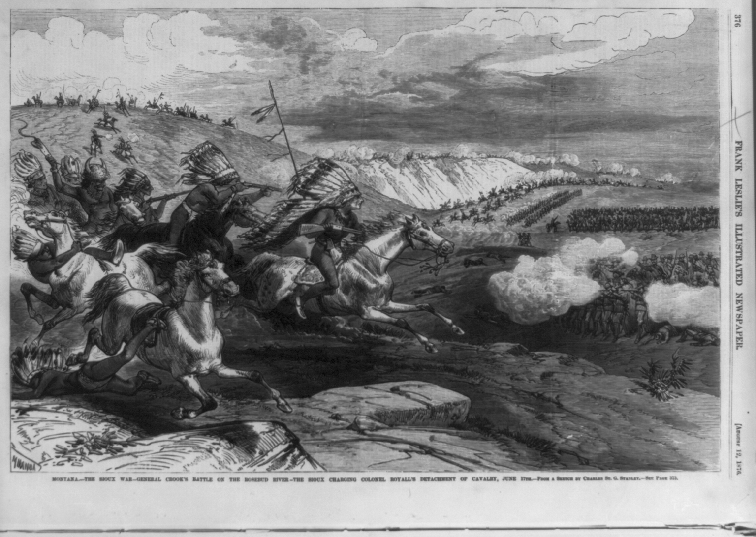
In 1890, Joseph F. Finerty a war correspondent for the Chicago Times, published a collection of his narratives from 1876 through 1879 titled “War-path and Bivouac, or the Conquest of the Sioux.” Here follows an excerpt:


Dawn had not yet begun to tinge the horizon above the eastern bluffs, when every man of the expedition was astir. How it came about, I know not, but, I suppose, each company commander was quietly notified by the headquarter’s orderlies to get under arms. Low cooking fires were allowed to be kindled, so that the men might have coffee before moving farther down the cañon, and every horse and mule was saddled and loaded with military despatch. Finerty notes that the Indians had a feast the night before and that the following morning the Crow were reluctant to go forward to meet the Sioux and Cheyenne, the Shoshone, however, showed some “martial alacrity.” They [the Cavalry and Scouts] got their horses ready, looked to their arms, and, at last, in the dim morning light, a large party left camp and speedily disappeared over the crests of the northern bluffs.

Finerty describes the Infantry moving out with their mules and other equipment. The Cavalry being generally bored and some even taking naps in the saddle until they all began with the “regularity of a machine complicated.” We marched in this fashion, the cavalry finally outstripping the infantry, halting occasionally, until the sun was well above the horizon. At about 8 o’clock, we halted in a valley, very similar in formation to the one in which we had pitched our camp the preceding night. Rosebud stream, indicated by the thick growth of wild roses, or sweet brier, from which its name is derived, flowed sluggishly through it, dividing it from south to north into almost equal parts. Our battalion (Mill’s) occupied the right bank of the creek, with the 2d Cavalry, while on the left bank were the infantry and Henry’s and Van Vliet’s battalions of the 3d Cavalry. The pack train was also on that side of the stream, together with such of the Indians as did not move out before daybreak to look for the Sioux, whom they were by no means anxious to find. The young warriors of the two tribes were running races with their ponies, and the soldiers in their vicinity were enjoying the sport hugely.


At 8:30 o’clock, without any warning, we heard a few shots from behind the bluffs to the north.  “They are shooting buffalo over there,” said the Captain [Sutorius]. Very soon we began to know, by the alternate rise and fall of the reports, that the shots were not all fired on one direction. Hardly had we reached this conclusion, when a score or two of our Indian scouts appeared upon the northern crest, and rode down the slopes with incredible speed. “Saddle up, there - saddle up, there, quick!” shouted Colonel Mills, and immediately all the cavalry within sight, without waiting for formal orders, were mounted and ready for action. General Crook, who appreciated the situation, had already ordered the companies of the 4th and 9th Infantry, posted at the foot of the northern slopes, to deploy as skirmishers, leaving their mules with the holders. Hardly had this precaution been taken, when the flying Crow and Snake [Shoshone] scouts, utterly panic stricken, came into camp shouting at the top of their voices, “Heap Sioux! Heap Sioux!” gesticulating wildly in the direction of the bluffs which they had abandoned in such haste. All looked in that direction, and there, sure enough, were the Sioux in goodly numbers, and in loose, but formidable array. The singing of the bullets above our heads speedily convinced us that they had called on business. Finerty doesn’t run out of adjectives to describe the bravery and fortitude of his company; Finerty never holds his callous estimation for the “inferior” race in check, clearly showing present day readers he was a man of his time. “Why the d---l don’t they order us to charge?” asked the brave Von Leutwitz. “Here comes Lemley (the regimental adjutant) now,” answered Sutorius. “How do you feel about it, eh?” he inquired, turning to me. “It is the anniversary of Bunker Hill,” was my answer. “The day of good omen.” “By Jove, I never thought of that,” cried Sutorius, and (loud enough for the soldiers to hear) “It is the anniversary of Bunker Hill, we’re in luck.” The men waved their carbines, but didn’t cheer. Lemley came bounding up on his horse. “The commanding officer’s compliments, Colonel Mill!” he yelled. “Your battalion will charge those bluffs on the center.”

Mills shouted the charge, and Troops A, E, I, and M went to meet the Sioux on the bluff. At about fifty paces the Sioux line broke. When Mills and his troops reached the crest of the bluff, they immediately formed a line. General Crook ordered the 2nd Battalion of the 3rd Cavalry under Col. Guy V. Henry to charge the right flank of the broken Sioux line.

General Crook kept five troops of the 2d Cavalry, under Noyes, in reserve, and ordered Troops C and G of the 3d Cavalry, under Captain Van Vliet and Lieutenant Crawford, to occupy the bluffs on our left rear, so as to check any movement that might be made by the wily enemy from that direction. General Crook estimated that they faced a Sioux force of about 2,500 warriors. The Sioux reformed another line on the second line of heights from Rosebud Creek. Finerty suggests that it was likely Crazy Horse directing and signaling the Sioux with a pocket mirror. Under Crook’s orders, our whole line remounted, and, after another rapid charge, we became masters of the second crest. When we got there, another just like it rose on the other side of the valley. There, too, were the savages, as fresh, apparently, as ever. We dismounted accordingly, and the firing began again. Colonel Mills, who had active charge of our operations, wished to dislodge them. The firefight shifted from Mills’ position to Maj. Evan’s position to the left. Mills led a charge into the valley under cover of the rocky terrain there. The Crow and Shoshone joined the fight led by Maj. Randall. The two bodies of savages, all stripped to the breech-clout, moccasins, and war bonnet, came together in the trough of the valley, the Sioux having descended to meet our allies with right good will. They began a most exciting encounter. Our regulars did not fire because it would have been sure death to some of the friendly Indians, who were barely distinguishable by a red badge which they carried. An Infantryman, Sergeant Van Moll joined the fight. Finerty found it strange that casualties on both sides couldn’t have exceeded more than twenty-five; he also remarks that war cries were constant on both sides. Since this fight was an “Indian” fight, one could safely speculate that the warriors on both sides were fighting for war honors, such as counting coup.

Sergeant Van Moll found himself fighting alone, when the Shoshone and Crow fled from the Sioux. A diminutive Crow scout, “Humpy,” made a bold rescue of Van Moll – and returned to the cheers of all the Cavalry and Scouts.

In order to check the insolence of the Sioux, we were compelled to drive them from the ridge. Colonel Royall met with difficulty on his front. Captain Vroom was deceived by the terrain and became overwhelmed. Lieutenant Foster and Lieutenant Morton, and Captain Andrews (Troop I) extricated Vroom. In repelling the audacions [sic] charge of the Cheyennes upon his battalion, the undaunted Colonel Henry, one of the most accomplished officers in the army, was struck by a bullet, which passed through both cheek bones, broke the bridge of his nose and destroyed the optic nerve in one eye. His orderly, in attempting to assist him, was also wounded, but temporarily blinded as he was, and throwing blood from his mouth by the handful, Henry sat his horse for several minutes in front of the enemy. He finally fell to the ground, and, as that portion of our line, discouraged by the fall of so brave a chief, gave ground a little, the Sioux charged over his prostrate body, but were speedily repelled, and he was happily rescued by some soldiers of his command.

As the day advanced, General Crook became tired of the indecisiveness of the action, and resolved to bring matters to a crisis. He rode up to where the officers of Mill’s battalion were standing, or sitting, behind their men, who were prone to skirmish line, and said, in effect, “It is time to stop this skirmishing, Colonel. You must take your battalion and go for their village away down the cañon.” “All right, sir,” replied Mills, and the order to retire and remount was given. The Indians, thinking we were retreating, became audacious, and fairly hailed bullets after us, wounding several soldiers. Our men, under the eyes of the officers, retired in orderly time, and the whistling of the bullets could not induce them to forget that they were American soldiers. Under such conditions, it was easy to understand how steady discipline can conquer mere numbers. 

The bluffs, on both sides of the ravine, were thickly covered with rocks and fir trees, thus affording ample protection to the enemy, and making it impossible for our cavalry to act as flankers. We began to think our force rather weak for so venturous an enterprise, but Lieutenant Bourke informed the colonel [Mills] that the five troops of the 2d Cavalry, under Major Noyes, were marching behind us. A slight rise in the valley enabled us to see the dust stirred up by the supporting columns some distance in the rear.

The day had become absolutely perfect, and we all felt elated, exhilarated as we were by our morning’s experience. Nevertheless, some of the more thoughtful officers has their misgivings, because the cañon was certainly a most dangerous defile, where all the advantage would be on the side of the savages. 


Noyes, marching his battalion rapidly, soon overtook our rear guard, and the whole column increased its pace. Fresh signs of Indians began to appear in all directions, and we began to feel that the sighting of their village must be only a question of a few miles further on. We came to a halt in a kind of cross cañon, which had an opening toward the west, and there tightened up our horse girths, and got ready for what we believed must be a desperate fight. Finerty remarked that Gruard’s keen ears heard gunfire toward the “occident.” Major A. H. Nickerson raced to where Colonel Mills and other officers were on the bluffs.

“Mills,”he [Maj. Nickerson] said,”Royall is hard pressed, and must be relieved. Henry is badly wounded, and Vroom’s troop is all cut up. The General orders that you and Noyes defile by your left flank out of this cañon and fall on the rear of the Indians who are pressing Royall.” This, then was the firing that Gruard had heard.


Crook’s order was instantly obeyed, and we were fortunate enough to find a comparatively easy way out of the elongated trap into which duty had led us. We defiled as nearly as possible, by the heads of companies, in parallel columns, so as to carry out the order with greater celerity. They carefully moved around boulders and fallen timbers. When they crested the crown of the plateau, they could hear the attack on Royall’s troop. “Prepare to mount - mount!” shouted the officers, and we were again in the saddle. Then we urged our animals to their best pace, and speedily came in view of the contending parties. The Indians had their ponies, mostly guarded by mere boys, in rear of the low, rocky crest which they occupied. The position held by Royall rose somewhat higher, and both lines could be seen at a glance. There was very heavy firing, and the Sioux were evidently preparing to make an attack in force, as they were riding in by the score, especially from the point abandoned by Mill’s battalion in its movement down the cañon, and which was partially held thereafter by the friendly Indians, a few infantry and a body of sturdy mule packers, commanded by the brave Tom Moore, who fought on that day as if he had been private soldier. Suddenly the Sioux lookouts observed our unexpected approach, and gave the alarm to their friends. We dashed forward at a wild gallop, cheering as we went, and I am sure we were all anxious at that moment to avenge our comrades of Henry’s battalion. But the cunning savages did not wait for us. They picked up their wounded, all but thirteen of their dead, and broke away to the northwest on their fleet ponies, leaving us only the thirteen “scalps,” 150 dead horses and ponies and a few old blankets and war bonnets as trophies of the fray. Our losses, including the friendly Indians, amounted to about fifty, most of the casualties being the 3rd Cavalry, which bore the brunt of the fight on the Rosebud. Thus ended the engagement which was the prelude to the great tragedy that occurred eight days later in the neighboring valley of the Little Big Horn.


According to the Biographical Directory of the United States Congress, Finerty was born in Galway, Ireland, 1846, immigrated to the United States in 1864 and immediately enlisted in the Ninety-Ninth Regiment of the New York State Militia. During the “Indian Wars,” Finerty corresponded with at least three newspapers, most often with the Chicago Times, during the “Indian Wars” from 1876-1881. He established his own weekly paper, the Citizen in 1882 and the following year was elected to the Forty-eighth Congress as an Independent Democrat. He died in June of 1908 and was interned in Cavalry Cemetery , Chicago, Ill.