Friday, August 19, 2016

Cannonball, The Historical Review Process

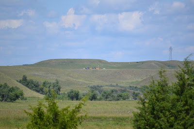
DAPL machinery waits on the north bluff of the Cannonball River. 
Cannonball
Íŋyaŋwakaǧapi Wakpá
By Dr. Tom Isern
Fargo, ND - It’s all quiet on the Cannonball. For the moment. This is a good time to reflect on how we got to the point where an out-of-state energy transport company, here operating under the (rather ironic) name Dakota Access, manipulated our sworn officers of the law into confrontation with the native citizens of North Dakota.

Bear with me on this, because it requires some attention span. And there is required reading, too. Begin with a document on this page: http://history.nd.gov/hp/sire.html...

Here’s why I think you should look at this obscure manual of practice. Issued by the Historic Preservation Department of the State Historical Society of North Dakota, it details the requirements for “Cultural Resource Inventory Projects.” Yeah, I know, I think they meant to say “Inventory,” but that’s not the point. The manual codifies the expectations of cultural resource contractors--usually archaeologists--submitting work for review. This includes the studies required parcel to environmental assessments for construction projects, such as the Dakota Access pipeline.

All such work, like any reputable science, begins with a literature review. Now, archaeologists like to do field work. They aren’t so keen about book work. So, the authors of the guidelines spelled out clearly what they expected every research entity to accomplish with the literature review. You can read for yourself in the manual, but I will summarize here the three essential points.

1.    Review the site files and other materials already of record in the historic preservation department.

2.    Make use of the published, textual sources for history and archaeology in the study area.

3.    Interview persons with personal knowledge of the area.

But, really, isn’t archaeology about fieldwork? Why bother with this review-of-literature stuff?

Because, North Dakota is a huge place. Even a defined study area is too large to cover foot-by-foot with pedestrian survey. You need that boots-on-the-ground work, but if you’re just walking around out there, or even working the ground in systematic fashion, you’re going to miss a lot of stuff.

Think of it like this. If I start walking across a 5000-acre pasture looking for sharptail grouse, on my own, I may or may not be lucky enough to stumble across one. But if I start across guided by my trusty retriever, and follow where she leads me, I will find birds just about every time. You have to hunt where the birds are.

Historical sources tell you where to concentrate your survey efforts, so that you actually find stuff. Maybe that’s the problem here. If you want to find stuff, you consult the sources. If you don’t want to find stuff, don’t look at the sources.

Wait a minute, why would a researcher not want to find stuff? I’m a researcher, and I love to find stuff! The answer is, these cultural resource contractors work for the people, like Dakota Access, who want to build things, in ways that do violence to heritage resources, if you’re not careful. When cultural resource surveyors find things, that’s nothing but trouble for the people who pay them.

At this point, if you’re unfamiliar with the system of cultural resource management, you’re wondering how this makes sense. The point is, it does not. We set up a process ostensibly intended to safeguard our heritage resources. To do this, we require that before a party goes ahead with a big project, it has to submit a cultural resource survey and establish that the project will not do unreasonable amounts of damage to historic and archeological resources. Such a study is supposed to identify and locate the resources to be safeguarded. The study is conducted, however, by a contractor hired by the party desiring to do the project, such as the Dakota Access pipeline. Dakota Access pays the bills. Moreover, the companies who do such cultural resource work specialize in it and depend, for their existence and profit, on repeat business. The incentive, therefore, is not to find stuff, to go through the motions, but to bring in a report that satisfies the company which pays the bill.

You can read the environmental assessment for the Dakota Access project here: http://cdm16021.contentdm.oclc.org/...

I also have seen sections of the cultural resource study that is part of the EA. The cultural resource study is not included in the online posting. It is withheld because if people knew where to find archeological sites, they might loot them for artifacts. Such caution is standard practice, allowed by state statute--although it appears in this case to be redundant, because at least in the section dealing with Morton County, the researchers, surprise, didn’t find anything.

And why didn’t they find anything? Because, far as I can see, there is no evidence the cultural resource contractors even pretended to meet the minimum requirements for documentary research. And because of that failure, they missed known sites of profound significance and importance--some of them, in fact, visible in Google Earth, for Pete’s sake.

It is time for concerned parties to examine the primary text on this matter, the cultural resource study on file in the historic preservation department of the state historical society, and to determine to what degree, if any, it meets requirements for such surveys. I have seen enough to know it is deficient. The only question is, how deficient. Now would be an excellent time for the Standing Rock Sioux Tribe to organize a qualified investigative team and dispatch it to the heritage center to determine the extent of deficiency. The findings would be important to legal proceedings currently in progress. It appears that all regulatory approvals of the Dakota Access project have been based on faulty intelligence.

There is a final issue I must address, although it pains me. I am a historian, and a sustaining member of the State Historical Society of North Dakota. The cultural resource study for the Dakota Access project came to the historic preservation department of the SHSND for review; the department accepted it, despite its failure to meet requirements; and thus it certified to the North Dakota Public Service Commission and other agencies that the Dakota Access project would do no harm to heritage resources. The statement of the SHSND, in its letter of 26 April 2016, was unequivocal: “No Historic Properties Affected.” That statement was based on demonstrably deficient studies.

How can this happen? There are three possible explanations.

1.    Time constraints - the SHSND simply lacked the staff to exercise due diligence.

2.    Lack of competence - the SHSND dropped the ball.

3.    Conflict of interest - the SHSND averted it gaze.

That third possibility, conflict of interest, is most disturbing. Energy firms are seven-figure donors to the SHSND. In fact, when the legislature only partially funded the new North Dakota Heritage Center, the SHSND made it known that it looked to energy companies as its main reliance for funding. And so it was done.

Let me make this plain: I am not accusing anyone, or any agency, of wrongdoing or bias. I am saying that so long as this conflict of interest exists, the public will view the pronouncements of the SHSND with suspicion.

It is long past time for the SHSND to deal with this problem. It is possible, through a transparent process of recusal by conflicted parties and involvement of unbiased reviewers, to solve it. As a member of the SHSND, I say, let this reform commence immediately.

Dr. Isern heads up the Center For Heritage Renewal at North Dakota State University. Check it out. 


At The Heart Of The World, A Review

The cover features a beautiful scene by American western artist William Jacob Hays, Sr., straight from 1863, and a Karl Bodmer painting of the Mandan Mandeh Pahchu in 1840. 
At The Heart Of The World, A Review
Survey History Reveals Native Homesteads
A Book Review By Dakota Wind
Bismarck, ND – In March 2014, Dr. Elizabeth Fenn’s seminal work on the history and culture of the Mandan Indians Encounters At The Heart Of The World: A History Of The Mandan People was published. The following year her work won the Pulitzer Prize for History.

Fenn is a historian. Naturally, she meticulously researched the primary resource documents like journals and maps. She isn’t an archaeologist or a geologist, and she’d be the first to tell you, but she immersed herself in the surveys, visited many of the sites first-hand, and then constructed a narrative of her experience of North Dakota making her research a little more personalized with exposition of the modern landscape, and produced an amazing piece of history that is easy to read and follow.

In light of the current energy interests in the Cannonball River vicinity, here follows a ten paragraph excerpt of Encounters At The Heart Of The World which details some history, geology, and cultural occupation:

A map on page seventeen, one of several appearing in Fenn's book. 

THE CANNONBALL RIVER
The Cannonball River starts in Theodore Roosevelt country – at the edge of the North Dakota badlands where, in the 1880s, the Harvard-trained politician found solace and manhood after personal tragedy sent him reeling. From here, the stream flows east across 150 miles of treeless plains and enters the Missouri not far above the South Dakota border. The confluence is today obscured by the waters of Lake Oahe, but there was a time when that confluence intrigued nearly every Missouri River traveler. Scattered along the shoreline and protruding from the banks were hundreds of stone balls, some as big as two feet in diameter.

These stone balls are the product of the ancient Fox Hills and Cannonball sandstone formations, deposited by inland seas that inundated the landscape for nearly half a billion years. Seventy million years ago, continental uplift caused the waters to recede and the sea floor to emerge, visible today as undulating plain. By slicing through this surface to expose the layers of sediment below, the Cannonball River revealed the land’s ancient, hard-to-fathom aquatic history. The Fox Hills and Cannonball strata are rich in minerals, especially calcium carbonate – a vestige of marine animals such as crabs, which often appear fossilized in these formations. When groundwater flows through the sandstone, the calcium crystallizes with other minerals and forms concretions – literally concrete – of a spherical shape.

William Clark, who examined the mouth of the Cannonball as he and Meriwether Lewis headed up the Missouri River on October 18, 1804, noted that the balls were “of excellent grit for Grindstons.” His men selected one “to answer for an anker.” The German prince Maximilian of Weid viewed the distinctive globes from the deck of a steamboat in June 1833, The Cannonball River “got its name,” he explained, from the “round, yellow sandstone balls” along its shoreline and that of the Missouri nearby. They were “perfectly regularly formed, of various sizes: some with a diameter of several feet, but most of them smaller.” Today, they are little more than a curiosity. Local residents use them as lawn ornaments.

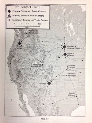
A map from page nineteen detailing continental trade to the Mandan Indian villages. Note: map says "Pre-contact Trade." 

AT THE CONFLUENCE OF THE CANNONBALL AND MISSOURI RIVERS, 1300
For ancestral Mandans, the migration farther north and the construction of new towns may have mitigated the threat of violence. Though they fortified some of their new settlements, they built others in the open, unfortified pattern of old, with fourteen to forty-five lodges spread over as many as seventeen acres. One such town sat on the south bank of the Cannonball River where it joins the Missouri, in what is now the Standing Rock Sioux Reservation.

The South Cannonball villagers tapped a wide array of food resources. In the short-grass prairies to their west, herds of bison beckoned hunters. In the mixed- and tall-grass lands across the Missouri to the east, antelope, deer, and small game did the same. The riverbanks brimmed with seasonal chokecherries, buffalo berries, serviceberries, raspberries, plums, and grapes, while river-bottom gardens produced a bounty of maize, beans, squash, and sunflowers. The Missouri itself offered catfish, bass, mussels, turtles, waterfowl, and drowned “float” bison, this last considered particularly delectable.

Much of the South Cannonball village site has succumbed to the steel plows of more recent farmers tilling the soil here, but the layout of the ancient village is clear. The settlers dispersed their town over fifteen acres, with ample space between individual homes. The houses themselves, about forty in number, were nearly rectangular log-and-earth structures, narrower at the rear and wider at the front.

There were no fortifications. It appears that the occupants of the South Cannonball hamlet counted on peaceful relations with neighboring villagers and with the hunter-gatherers who may have visited from time to time. But fortified towns nearby suggest that security was tenuous. South Cannonball may have been on the last villages to follow the scattered settlement pattern of earlier days. By the mid-1400s, the same neighborhood was home to some of the most massively defended sites ever seen on the Upper Missouri River.

Fenn’s narrative reconstructs a historic Mandan presence in the vicinity of the Cannonball River. Where Dr. W. Ray Wood focused more on the physicality of the north bank of the Cannonball, Fenn brings a living history lens to the south bank of the same.

Fenn cares about the people she has written about, actually making friends on each trip she takes to the Northern Great Plains. She knows that no matter how carefully she constructed her narrative, that there would be some among the Mandan who don’t embrace her interpretation, and she accepts that even as she acknowledges them. She cares about the history. She cares about the people. Her work reflects that and it is no wonder her work received such acclaim.

You can get your copy of Fenn’s Encounters At The Heart Of The World: A History Of The Mandan People at the North Dakota Heritage Center and Museum’s store. The book isn't listed on the website, but its on the floor. 


Another America, A Review

The cover of Warhus' "Another America" features the third section of Sitting Rabbit's map of the Missouri River. 
Another America: Native American Maps
Big River Villages At Cannonball River
A Book Review By Dakota Wind
Bismarck, ND – In 1997, Mark Warhus, published his work Another America: Native American Maps And The History Of Our Land. Warhus carefully examined and researched Native American maps from a variety of mediums from petroglyphs and bark to animal hide and paper, from pre-contact to post-reservation.

In the pre-contact days and through post contact, when maps were drawn, it was only at great need. Mapping the land was through language (both oral and sign), before it was ever drawn. When a map was rendered, it was also done with a unique world view. For some tribes, east, the direction of the sunrise was the direction to orient oneself. For others it was the mountains to the west. For the Lakȟóta it was the south, the direction upon which pulls the water.

According to Warhus, “When a map was needed to show the way or convey a message, it would be drawn out on the ground, in the snow, or in the ashes of a campfire. These drawings were transitory illusions for the oral documents.” The oral document to which Warhus refers to is the sense of time it might take to reach an objective. How many days or nights it might take, or how many “sleeps.” The oral document may include tribal entities in a landscape, and whether one was on friendly terms with them. The oral document certainly included rivers, streams, and bodies of water.

Western maps are oriented to the north, and detail things like miles, elevation, latitude, and longitude, as if the landscape were nothing without being measured. The native maps, oral and drawn, are maps of experience.

Warhus details the dispossession of the landscape and the renaming of it. His work doesn’t serve as an apology for what happened, but exclaims at the loss of historical and cultural information, while rejoices in the maps that have survived calling them “documents of resilience and survival.”

Another America includes the Mandan Indian Sitting Rabbit’s map of the Missouri River that depicts an old Mandan town south of present-day Fort Yates, ND on the south bank of what is known variously today as Ókaǧa Wakpá (“Floater’s Creek”), Akíčhita Haŋská Wakpá (“Long Soldier Creek”), or the Four Mile Creek. The Mandan town was known as Mida Oduk Kua Atis (“Village Of Woods Confluence”).

A picture from page 47 of Warhus' "Another America" features the third section of Sitting Rabbit's map of the Missouri River. Note: the Big River is the Cannonball River.

Sitting Rabbit’s map goes as far north as the confluence of the Yellowstone and Missouri Rivers. The map does more than just mention place, but details history and names of sites from hundreds of years ago, places the Mandan don’t live at anymore. One such site in particular deserves to be mentioned here in light of current energy interests and that is the two Mandan villages on both the south and north banks of the Cannonball River. The historic Mandan referred to the Cannonball River as the Big River. The two villages there were known as As Irtia Athis [transcription may be incorrect] (“Big River Villages”).

Sitting Rabbit’s map tells us that the Mandan regularly crossed the river to hunt bison along Beaver Creek, chasing them to a location they called Mysterious Corral, or what is today known as Little Beaver Creek. This method of hunting bison fell out of practice after the arrival of the horse. The map also names the hill, upon which the water tower rests in the community of Cannonball, as Bison Ear Hill.

Warhus’ book, and all the maps therein, are treasures. They detail inter-tribal conflicts, inter-tribal trade and commerce, hunting and fishing, and history reaching back hundreds, if not a thousand years or more.

Many of the illustrations and maps are in color. One almost wishes that this book were published in a larger format to really appreciate the detail and texture of the maps, but don't let this stop you from adding this to your home or work library. Get your copy of Mark Warhus’ Another America: Native American Maps AndThe History Of Our Land


Thursday, August 18, 2016

Remarkable Places Around Cannonball, A Review

The cover to "Prologue To Lewis & Clark" features a 1795 map by Antoine Soulard. "There is probably no scholar more qualified to write on this subject than Wood," said James P. Ronda in his review. 
Prologue To Lewis And Clark
Remarkable Places Around Cannonball
A Book Review by Dakota Wind
Bismarck, ND – Wood’s book, “Prologue To Lewis And Clark: The Mackay And Evans Expedition,” is a wonderful combination of research and composition relating to the expedition almost ten years before the Corps of Discovery arrived on scene. The work isn’t loaded with archaeological narrative nor bogged down in the weight of its own revelation, but is carefully and deliberately written with the common reader in mind.

At five chapters and only 255 pages, Prologue is amazingly concise, and features maps by John Evans and Antoine Soulard, and maps of the explorations reconstructed by Wood’s own meticulous research.

Wood is Professor Emeritus of Anthropology at the University of Missouri, Columbia. He is an acknowledged expert of archaeology on the Missouri River by the State Historical Society of North Dakota and many other fine institutions, state, federal, and tribal, across the country. Wood has over fifty years of experience from before the federal dam projects of the 1950s to general field work at the Mandan Indian village Double Ditch in recent years.

Here’s a three paragraph (pp. 109-110) excerpt from Wood’s “Prologue To Lewis And Clark: The Mackay And Evans Expedition.”

Page 147 features sheet 5 of the Beinecke Library Map. 

Chapter Four
The Missouri River Basin Explored
“Those Remarkable Things Mentioned By Evans”

Between Beaver Creek and the Cannonball River, there is a sequence of small named and unnamed islands and tributary streams. [Wood is/was unaware of these streams having names in any of the native languages.] Evans called the Cannonball River the “Bomb River,” a name we also may presume to derive from his hypothesized companion. (In this instance, we may speculate on a French origin, for an Indian identification of the individual is improbable.) “Bomb” is an appropriate name, for the banks and valley of this stream once were home to uncounted spherical sandstone concretions that ranged from a few inches to several feet in diameter. Some of them indeed were the size of cannonballs. Today they have been carried away by curio hunters in such numbers that they are very rare.

The mouth of the Cannonball, which Evans said was 150 yards wide, marks the south end of a high, steep bluff that extends for four miles upriver along the west bank of the Missouri. It was here that William Clark “walked on Shore, in the evining with a view to See Some of those remarkable places mentioned by evens, none of which I could find.” Unfortunately, we cannot determine what those “remarkable places” might have been by looking at Evans’s narrative; if it was consulted by Clark, it is no longer available to us today. Nor are there clues to their identity in Clark’s subsequent notes, perhaps because he did not begin his search until he had passed the mouth of modern Badger Creek, thus being upstream from three locations on Evans’s map that modern viewers find so intriguing. But the map that Evans made of his voyage contains several clues to those “remarkable places.” The four-mile-long bluff above the Cannonball is called the “Hummit” (or “Hermitt”) on his chart – a term that so far defies explanation. Two features that he names on the rim of Humitt Bluff demonstrate that here he was following the river uplands on foot, for the features he notes would have been invisible from the river channel two hundred feet below its rim.

Page 111 from Wood's book features an aerial view of the mouth of the Cannonball River. Eagle eyed readers should be able to make out the curved fortification ditch in this image. Google Earth users can zoom in and view the area for themselves. 

One notation reads “Jupiter’s Fort,” which a hand-and-finger pointing to the north side of the Cannonball River atop the south end of Humitt Bluff. There is no doubt that this refers to a prehistoric Mandan village at that location overlooking the mouth of the Cannonball. Today, archaeologists call this village the North Cannonball site. Not only was it a defensive setting, but the village also was fortified by a curving ditch that isolated a lever upland spur from the adjoining upland. The village today is badly disturbed by plowing, but from the air one can clearly see the fortification ditch and the numerous bastions protruding from it. Little wonder that Evans referred to it as a fort, though his reference to Jupiter is not explainable.

In light of the current energy interests on the north side of the mouth of the Cannonball River, one might be inclined to review the historical properties that are about to be disturbed. Get your copy of W. Raymond Wood’s “Prologue To Lewis And Clark: The Mackay And EvansExpedition” today. Contact the North Dakota Heritage Center and Museum's Store at (701) 328-2822 for available copies. 


Sunday, August 14, 2016

Water Determines Territorial Boundaries

Dakota Access Pipeline equipment is on site on the north bank of the Cannonball River, ND.
Hunkpapa and Yanktonai Homeland 
Traditional Territory Defined by Water
By Dakota Wind
Cannonball, ND – In 1915, Colonel Welch met Wakíŋyaŋ Tȟó (Blue Thunder), a renowned camp crier (his voice was said to have carried five miles) and traditional historian of the Iháŋktȟuŋwaŋna Dakȟóta and Húŋkpapȟa Lakȟóta at Fort Yates, ND. Welch asked Blue Thunder from where he came. Blue Thunder replied that he was born on Tȟaspáŋna Wakpána (“Thorn Apple Creek;” Apple Creek), or Bismarck, ND.

Blue Thunder’s answer reflected the pre-reservation tradition of naming the stream along which one was born, from which one came, by way of introductions. It also enforced the ideology of territorial boundary. The post reservation Dakȟóta or Lakȟóta named the tribe (or campfire)/band one belonged to, or whose parents belonged to, in introduction. Today, a Dakȟóta or Lakȟóta is likely to name his or her agency where he or she is enrolled at, in introduction.

In 1796, John Evans established Jupiter’s Fort, on the north bank of the Cannonball River. The Blue Thunder Winter Count and the No Two Horns Winter Count recall Evan’s arrival with an image of the British Union Jack and the accompanying entry: Wówapi waŋ makȟá kawíŋȟ hiyáyapi (Flag/book a earth to-turn-around came-and-passed-along-they), or” They brought a flag around the country.”

Evans chose the location for his trading post with an eye towards finding a safe middle ground amongst the
Šahíyela (Cheyenne), the Mawátani (Mandan) and Ȟewáktokta (Hidatsa), the Phadáni (Arikara), the Iháŋktȟuŋwaŋna, and the Húŋkpapȟa. That middle ground was near the confluence of the Íŋyaŋwakaǧapi Wakpá (Stone Production River; Cannonball River) and Mníšoše (The Water Astir). This site was generally held to be sacred by all the regional tribes.

The Nu’Eta (“The People,” as the Mandan refer to themselves) regard the twin buttes there on the south bank of Íŋyaŋwakaǧapi Wakpá with reverence, and is tied to their flood story. An old Mandan village is located in close vicinity of Jupiter’s Fort. The Sahnish (as the Arikara call themselves) lived there too for a time before moving to Míla Wakpá (Knife River; present day Stanton, ND). An ancient declaration inspired the Sahnish to ascend the Mníšoše, and they did, breaking away from their Caddo relatives a thousand years ago, then breaking away from their Pawnee relatives in the past three hundred.

A look across to the east bank of the Missouri River, the ancient homelands of the Arikara and the Yanktonai Dakota. 

Where the Íŋyaŋwakaǧapi Wakpá converges with the Mníšoše, the hydrographical energy of the two resulted in a great swirl in the river. From this whorl of water was shaped the cannonball stones of various sizes. According to Jon Eagle Sr, Tribal Historic Preservation Officer at Standing Rock, since the creation of Lake Oáhe (Something To Stand On), the whorl no longer labors to fashion the round stones.

In 1763, according to the Brown Hat Winter Count, in the vicinity of the Íŋyaŋwakaǧapi Wakpá, there came an Oglála war party to fight the Šahíyela who lived nearby. The war party fought their fight and returned to the east bank of the Mníšoše. The Šahíyela retaliated by crossing the Mníšoše and setting the plains afire. The wind carried the fire directly to the Oglála camp, causing a great run for Blé Haŋská (Long Lake). The fire caught up to them before the survivors jumped into the lake, burning many. The survivors were thereafter called Sičáŋǧu (Burnt Thighs).

A painted bison robe depicting a conflict between the Arikara, Hidatsa, Mandan, Hunkpapa, and Yanktonai in 1798. 

In 1798, according to the Pictographic Bison Robe (of Mandan manufacture, gifted to the Corps of Discovery in 1804) the Iháŋktȟuŋwaŋna and Húŋkpapȟa went to war against the Phadáni, Ȟewáktokta, and Mawátani. The war, one of many intertribal conflicts across the years, concluded in 1803, according to the John K. Bear Winter Count, at Čhaŋté Wakpá (Heart River). The northern territorial boundary of the Húŋkpapȟa then expanded north from Íŋyaŋwakaǧapi Wakpá.

The Šahíyela were living in a great earthlodge village at the place Where The Hill Stands Alone (Fort Yates, ND), up to 1803, but two things happened: the Battle of Heart River in which their Húŋkpapȟa and Iháŋktȟuŋwaŋna allies had expanded their territorial holdings, and the Cheyenne prophet Sweet Medicine’s message to abandon their sedentary life and move west to live and hunt as their Lakȟóta relatives.

The area in the vicinity of the mouth of Íŋyaŋwakaǧapi Wakpá is regarded as a sacred memorial by the Húŋkpapȟa and Iháŋktȟuŋwaŋna to a tragedy in 1825. Blue Thunder and No Two Horns recall the year as Mní wičhát’E (Water many-dead), or Dead bodies in the water. High Dog, a Húŋkpapȟa historian, recalls the same year as: Mní wičhat’Á (Water them-died), or Many had died by drowning.

Across the Missouri River and north of the Cannonball Wacipi (Pow-wow) grounds is the site of the deadly drowning incident of 1825.

High Dog’s winter count elaborates further stating They were camping on the bottomlands of the Mníšoše that spring when an unprecedented rise of water quickly drowned over one half of the people. They say that this happened on the east bank of the river, opposite of the mouth of the Cannonball River. The Dakȟóta call this place Étu Pȟá Šuŋg t’Á (Lit. Place Head Horse Dead; Dead Horse Head Point) because, following the flood, the shore was lined with dead horse heads. They had corralled their horses for the night and nearly all were drowned but for a few.

The drowned people and horses were interned in a low rising hill on the spot. This hill was submerged by Lake Oáhe in the 1950s. Locals in Cannonball, ND refer to the south bluff of Íŋyaŋwakaǧapi Wakpá, the west bank of the Mníšoše, the site opposite of Étu Pȟá Šuŋg t’Á, as “The Point.”

In 1840, according to Blue Thunder and No Two Horns, was the year Waáŋataŋ (The Charger) died, there in his last winter camp, along Čhápa Wakpá (Beaver Creek, ND) across the river from the humble community of Cannonball, ND. The Charger received an English captain’s commission in the War of 1812, leading as many as 600 Očhéthi Šakówiŋ (Seven Council Fires; “Sioux”) there at the Battle of Fort Meigs, the Battle of Fort Stephenson, and the Battle of Sandusky. The Charger met dignitaries such as President Martin Van Buren and King George III. He later led the Očhéthi Šakówiŋ under Col. Leavenworth’s command in the Missouri Legion in the first ever US military campaign against Plains Indians in the Arikara War of 1823.


According to the archaeological survey, there was no tribal consultation. Neither out of state firms mention the Arikara village, the Mandan village, Jupiter's Fort, the 1825 Dead Horse Head Point, nor the 1840 Charger's last camp. Update: The original image which appeared here might have resulted in the unnecessary destruction of the resource. It was removed at the request of the State Historical Society of North Dakota. Apparently the Dakota Access Pipeline will be installed with spoons, Shawshank Redemption style. 

In 2015, two archaeological firms surveyed a corridor for the Dakota Access Pipeline. The corridor plan calls for the pipeline to go through the Arikara, Mandan, Jupiter's Fort, near or through the 1825 drowning site, and through Capt. Charger's last camp on Beaver's Creek. In August of 2016, the Dakota Access Pipeline began to disturb this beautiful confluence of history and culture. Activists have set up camp and have begun to protest the pipeline construction. 

Using winter counts, and surviving oral traditions, one can reconstruct the landscape as the Očhéthi Šakówiŋ recall it, with waterways serving as boundaries.

A Lakota world view perspective of Makhoche Waste (The Beautiful Country; The Great Plains). Note: South is at the top of the page. 

The Húŋkpapȟa territorial boundaries extended from the mouth of the Čhaŋté Wakpá, west to the Heȟáka Wakpá (Elk River; Yellowstone River) and Čhaȟlí Wakpá (Charcoal River; Powder River), and back east along the Pȟaláni Wakpá (Arikara River; Grand River), then north along the Mníšoše back to Čhaŋté Wakpá.

The Iháŋktȟuŋwaŋ and Iháŋktȟuŋwaŋna territorial boundaries extended from the mouth of the Čhaŋté Wakpá, northeast to around Mní Wakȟáŋ (Spirit Lake; Devils Lake), all of Čaŋsáŋsaŋ Wakpá (White Birch River; James River) country, all of Šahiyela Ožú Wakpá (Cheyenne Garden River; Sheyenne River, ND), then south of where the Šahiyela Ožú Wakpá converges with the Mníša Wakpá (Red Water River; Red River of The North), then south towards the Čhaŋ’kasdáta Wakpá (Wood To Paddle Softly River; Big Sioux River), and south again towards the Mníšoše, then back north along the Mníšoše to the mouth of Čhaŋté Wakpá.

Water, especially the Mníšoše, has played an important role in the history of the Lakȟóta and Dakȟóta people. The direction the river flows has shaped the world view of them as well. South is called Itókaǧata, meaning “Facing Downstream.” Western worldview places north as the orienting direction, the opposite holds true for the Lakȟóta and Dakȟóta people.

Water determines boundaries. Water determines life.