Friday, August 9, 2013

The 1863 Apple Creek Conflict 150 Years Later

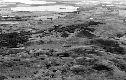
A composite panorama of Apple Creek from the northeast point of Pictured Bluff. The image is southwest (l) to north (r). 
The Dakota Conflict In Dakota Territory
The Apple Creek Conflict 150 Years Later
By Dakota Wind
BISMARCK, N.D. – The Mníšoše, Missouri River, moves determinedly along the ancient valley it has carved over thousands of years. The river flows in the very heart of the Great Plains, in fact, aside from the wind, it’s a defining feature of the prairie steppe. Its Lakȟóta name means “The Water A-stir” in reference to its muddy stirred up appearance in historic times. Commercial traffic on the river in the nineteenth century came to call it “The Big Muddy.”

Tȟaspáŋla Wakpála, Apple Creek, meanders along its own course from a field north and east of present-day Bismarck, N.D. The Menoken Indian Village rests along the quiet creek, a silent witness to trade in what archaeologists call the Late Woodlands period. The creek’s name refers to the tree that bears the tiny edible thorn apple.

Where the Tȟaspáŋla Wakpála converges with Mníšoše is Mayá Itówapi, Pictured Bluff. There, along the bluff are caves where the sediment is layered in colors. A testament to the changing climate throughout the ages of the world to the geologist, but to the Lakȟóta, it was a place to gather natural yellow and red pigments to create paint.

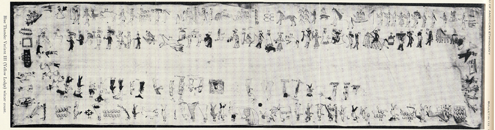
There was a conflict between the Pȟadáni (Arikara) and the Iháŋktȟuŋwaŋna (Yanktonai) in the 1830’s. According to the John K. Bear winter count the year is recorded as Čhaŋnóna na Pȟadáni ob thi apá kičhízapi, The Wood-Hitters (a band of the Iháŋktȟuŋwaŋna) fought with the Arikara. 


The Blue Thunder Winter Count, variant III.

The Waŋkíya Ťho, Blue Thunder, winter count correlates this event at a Dakota winter camp located below Čhaŋté Wakpá, Heart River. According to Blue Thunder, the assailants are variously identified as Arikara, Mandan, or Assiniboine. The Mandan Indians have the Foolish Woman winter count, and they record that they destroyed fifty lodges. The Tȟatȟaŋka Ska, White Bull, winter count has that winter as Wičhíyela waníyetu wičhákasotapi, the Yanktonai were almost wiped out that winter.

The John K. Bear winter count also mentions the Dakota Conflict in its 1863 entry: Isáŋyatí wašíčuŋ ob okȟíčize, the Santee warred with the whites. The Minnesota Dakota conflict is also reflected in the Red Horse Owner, Roan Bear, and Wind winter counts.

Clell Gannon, a depression era artist, painted this scene of General Sibley's command in pursuit of the Sioux. The painting can be found in the south vestibule of the Burleigh County Courthouse, Bismarck, ND.

The fight between the two tribes paled in comparison when in 1863, General Sibley and his command of about four thousand soldiers engaged the Dakȟóta and Lakȟóta people in a running battle lasting two weeks, from Big Mound (near present-day Tappen, N.D.) to Pictured Bluff.

Sitting Bull counts coup on one of Sibley's men and steals a mule at the Big Mound Conflict. The image was Sitting Bull's own account, from "Sitting Bull's Heiroglyphic Autobiography" which appears in Stanley Vestal's "Sitting Bull: Champion Of The Sioux."

In Tȟatȟáŋka Íyotake’s, Sitting Bull’s, own pictographic account, he placed himself at Big Mound where he rode into Sibley’s camp, stole a mule, and counted coup. It is almost entirely certain that if this great leader was at the beginning of the running battle, he was there to the end at Pictured Bluff.


The running battle began as a masterful retreat on July 24, 1863, across hilly terrain in a sinuous line back and forth across streams. This constant crossing, in effect, caused Sibley to lag behind enough for the Dakȟóta and Lakȟóta to gain enough lead time that the women, children, and elders could navigate their crossing waŋna hiyóȟpayA Tȟaspáŋla Wakpála hená Mníšoše, where the Apple Creek converges with the Missouri River.

That critical crossing came on July 29, 1863. The oyáte, people, abandoned their thiíkčeka, lodges, on the broad flood plain of the Mníšoše. A thousand lodges encircled two little lakes, sloughs in later years. They crossed the Mníšoše in as many as five places below Pictured Bluff. The warriors rallied together, perhaps under the leadership of Tȟatȟáŋka Íyotake or Phizí (Gall), and took the high ground a-top Pictured Bluff.

The women, children, and elders who made a successful crossing signaled the warriors with flashes of sunlight using trade mirrors. The warriors in turn, signaled back to their loved ones then they turned their attention to Sibley’s command. There is no exact number of warriors, but if there were a thousand lodges, then there was at least one able-bodied man or warrior per lodge. Using this projection, the warriors were outnumbered four-to-one.


Sibley and his men arrived on the scene, July 29, 1863, to witness flashes of light in communiqué to those in safety across the river. The general struck camp and named it “Camp Slaughter” after a doctor in his command. Over the course of the next few days, Sibley could not take the hill and some of his men were ambushed in the middle of the night. The morale of his soldiers suffered and on July 31, withdrew his men from the field when the enemy seemingly disappeared.

The Apple Creek Conflict is the only fight in the Punitive Campaigns of 1863 & 1864 in which the Dakȟóta and Lakȟóta chose the battlefield, met their aggressor, and held them off until they withdrew. This clear victory became entirely overshadowed by the tragedies of Iŋyáŋsaŋ (Whitestone Hill) and Tȟáȟča Wakútepi (Killdeer), and the victory of Pȟežísluta, the Battle of the Little Bighorn in 1876.


An unknown, or perhaps forgotten, artist pictographed this scene which was originally identified by Mike Cowdrey as "The Battle Of Whitestone Hill," but is quite possibly a Yanktonai account of the Apple Creek Conflict.

Susan Kelly Power, an esteemed uŋčí (grandmother) of the Iháŋktȟuŋwaŋna Dakȟóta and enrolled member of the Standing Rock Sioux Tribe and great-granddaughter of Chief Two Bear, has the oral tradition that places three warriors there at the Apple Creek Conflict: Callous Leg, Little Soldier, and Has Tricks. There must certainly be more warriors and oral traditions amongst the Iŋyáŋ Wosláta Oyáŋke, the community of Standing Rock, and others.

Today, a park named for General Sibley rests virtually where his Camp Slaughter once stood, where some of the Dakȟóta and Lakȟóta made their crossing. Bismarck has turned a battlefield into a place of recreation. There is no signage explaining the name of the park, nor of the conflict.

The landscape has been appropriated and development has erased the battlefield; Dakȟóta and Lakȟóta oral tradition recalls that the soldiers chased the people into the river. 

On July 29, 2013, 150 years after Sibley’s command withdrew entirely from the Apple Creek Conflict, the anniversary passed in silence. 

Thursday, August 8, 2013

Wamduska Bde: The Origin Of Stump Lake

Sunset at Stump Lake, N.D. Photo By Aaron Barth, The Edge Of The Village.
Wamduska Bde: Serpent Lake
The Origin Of Stump Lake
By Louie Garcia, Spirit Lake Oyate
SPIRIT LAKE, N.D. - They say a long time ago that there was no Stump Lake. The story goes that an underground fire, possibly a vein of coal, burned continuously for about forty years. The ground caved in upon itself, and water from nearby Spirit Lake rushed in to fill it. The tree stumps protruded from the lake inspired the Metis to call it Lac du Chilots, Lake of Snags, or Stump Lake.

The Dakota who lived in the region say that there's an ancient entity that inhabits Stump Lake, a great serpent they call in their language Wamduska, which means Creeping Thing or Serpent, which is one of sixteen spirits of Unktehi, or Large Water Monster. The Dakota came to call the new lake Wamduska Bde, or Lake of the Serpents.

The explorers, traders, and then settlers chose to call it Stump Lake. A name that reflects the natural history of the lake. Lake of the Serpents might have kept people away. 

Today Stump Lake is a place for recreation. Among the many events, which one might call the culture of North Dakota, are a threshing bee, a polka fest, craft shows, music & art, and a country fair. Visit Stump Lake Park for more information.

Monday, July 29, 2013

The Remains Of Killdeer Mountain

An outcropping of stone along the trail ascending Killdeer Mountain to Medicine Hole.
The Remains Of Killdeer Mountain
Industry Encroaches On Historical Landmark
By Dakota Wind
Killdeer, N.D. – A Lakota tradition is that blue is a sacred color, all colors are, but blue is special. It’s the color of heaven. It’s the color of Iŋyaŋ’s (Stone's, or Rock's) sacrifice and of life that came forth in the Lakota creation story.

Aŋpó, the sun, stepped above the far horizon and golden light poured into the Mnišoše (Water-Astir; Missouri River) valley. The sky was clear and clean. Not a cloud in heaven dare bar the sun today. An uncle of mine likened days like this to be very special. ”Waŋžila tȟó,” I heard him breathe out after a long yawn of air, “It means complete blueness or blue oneness.

A quiet wind kissed me on the face and through my hair on the way to my car. A wave of melancholy took me momentarily as I remembered my uŋči (grandmother) on mornings like this. She’d rise when the sun was just a promise of light on the lip of the world and she'd down a tall glass of water, praying in-between deep draughts, then she’d ready herself for a walk along the river.


The drive to Killdeer was pleasant. I carpooled with friends and we exchanged good conversation on the drive west. Both are archeologists and shared stories about work in the field. Conversation made the trip short and soon enough we were in the rumbling city of Killdeer.

We stopped at the city park where a motley collection of local landowners, historians, more archaeologists, a biologist, and members of various organizations had gathered in fellowship to see Killdeer Mountain before more industrial development lay claim to the earth.

I am reminded of an interpretation of eucharist after a round in introductions. It’s a religious term generally held to mean the part of a Christian service in which the Gifts are brought forward, the Thanksgiving. One of my university professors, a Benedictine sister, in class one day said that, too, when people come together for a common purpose, at a common time, and at a common place, that it is eucharist.


The introductions in and of itself, was held in a circle. There might not have been prayer, but I felt something mutual pass among everyone who was there.

A few local landowners, the Jepsons and the Sands, hosted a picnic on the rise of the west side of Killdeer Mountain. The modest spot of land was an old tipi encampment site. Tertiary flint flakes lay scattered about on unturned soil. Native grasses, medium or middle grasses, grew unhindered about the gentle rise. The gentle wind combed its breeze through the grass, the trees shushed the landscape, and thousands of native flowers crowned the hill in yellow, purple, blue, pink, and white.


 Ancient cracked and worried stone testified to archaeologists that the steppe was once under a vast freshwater ocean millions of years ago. Old shattered stone broke the soil in defiance of the wind and rain. The formations looked deceptively small from a distance. Either I shrank as I approached the stones or they grew with each step toward them.

In the days of legend, the Mandan said that the son of Foolish Boy was killed at the plateau by the spirits who dwelt there. Foolish boy retaliated by taking up his staff and struck the plateau, cleaving the plateau as we see it today. The Mandan know the mountain by another name, Singing Butte.

I embraced the illusion of the changing hillside and hiked up to the western most point of the Killdeer plateau. Deer lived there. Careless prances quickly turned to startled runs at the arrival of people. They were sunning themselves only moments earlier in the grassy rise as evidenced by depressions in the grass. A few ground plums were nibbled on and abandoned, but there were a few more near the top.

Looking north, here's one of the ravines which leaves the west side of Killdeer and goes west to Elk River (Little Missouri River).

From the top of the western most rise of Killdeer Mountain I saw two ravines stretching west through the cracked thirsty earth to Heȟáka Wakpá Makȟočhe (Elk River Country; the Little Missouri River). There, in 1864, after Sully’s assault on Sitting Bull’s Huŋkpapȟa camp on the southeastern rise of Killdeer Mountain, he ordered his soldiers to pursue the Lakȟóta into the Badlands.

The Lakȟóta had been at Killdeer Mountain for a few reasons, but the most important to the people was that it was a place to hunt. In Lakȟóta, they call the plateau Tȟáȟča Wakhúte, The Place Where They Kill Deer. In July, they were hunting and gathering some of the very foods I saw on my hike. Kȟáŋta (wild plums), maštíŋčaphuté (buffalo berries), čhaŋpȟáhu (chokecherry bushes), ptetȟáwote (ground plums) all upon the hillside in abundance.


 General Sully was there to level the might of the U.S. military upon the Sioux in a punitive campaign for the Eastern Dakota’s participation in the 1862 Minnesota Dakota Conflict. Aside from obliteration of homes, the deaths of as many as 300, about 150 prisoners, and destruction of foodstuff for the coming winter, Sully’s aggressive campaign succeeded in shaping the opinion of the Huŋkpapȟa and other Lakȟóta tribes throughout the era of western settlement. Warfare between traders, land surveyors, the railroad, settlers, and the Lakȟóta continued throughout the 1860s and 1880s.


I descended the western point of Killdeer Mountain enjoying the sun that warmed me and the breeze that cooled me. The hikers I was with, made a circuit of our ascension then descended on a ridge line back to the old encampment site. There, the contentment of edification and gratification washed away from me at the site of two oil stakes. Did I miss them somehow while the picnic was happening earlier? Did I look past the stakes? Did I preoccupy myself with the setting of old encampment site? I must have, and a dreadful feeling of fatalism filled me.

Industry will be here soon. The earth will be turned, a well pad and a road will go in, and physical memory of a Lakȟóta camp will vanish entirely.

Mr. Rob Sand and Ms. Lori Jepson reflected about the experience of preserving Killdeer Mountain. 

Two local landowners expressed their heartfelt wishes that they could have done more. When the oil companies came to gauge the earth for mineral extraction, they weighed the hearts and minds of an otherwise close-knit community. Some individual land owners were lured by the promise of an income far more than what the humble rancher earns through his sweat.

Rob Sand, one of the local landowners, was asked by a visitor from out of state if there was any one thing he could change, and without a moment’s hesitation, Sand simply replied, “I would change the minds of the Industrial Commission.” Sand, a common man who holds the land dear as his settler ancestors and who finds beauty in the untouched and unturned land, carefully articulated - but not once criticized the character of the men who make up the North Dakota Industrial Commission nor the Director of the North Dakota Department of Mineral Resources - his deepest desire to preserve the history and heritage of the Killdeer Mountain.

The oil under the Killdeer plateau isn’t much, somewhere between three and three and a half million barrels of oil, but its enough that it’s considered a waste if its left there. That’s enough oil to power to the United States for over four hours, if it’s going to the U.S.

A golden eagle flew straight out of a nest near the top of Killdeer Mountain. 

A visit to the Killdeer Mountain conflict site was capped by the regal nature of the eagles’ aeries on a south facing cliff side of Killdeer Mountain. Golden eagles ride the endless prairie wind, a wind that has been a constant presence since before the landscape was under the ocean, since before Foolish Boy cracked the plateau.

Jagged cracked stone reaches out from Killdeer Mountain.

The climb up the mountain to the summit to where Medicine Hole sings is filled with pauses to enjoy the view by some. I look at the degree of ascension, anywhere from a 30° incline at the base to 90° on the cliff side. I imagine women holding babies and shepherding children in an escape from Sully’s command and thanked God I’m here today.

Indian Paint. My pictures of this flower did not turn out. Here is an image from Wikimedia Commons. 

Orange lichen clings to shattered stone. A forest of stunted white birch grows on the south face about half-way to the flat summit. More native flowers, purple, grow delicately in the cracks and crevices. Some Lakȟóta smile and call it “love medicine.” I recognize one yellow flower that some call “Indian Paint.” With it, one could acquire a yellow or purple pigment.

Along the way, a work crew had placed seismic sensors to measure the impact of oil wells a half-mile away, which makes me conscience of the well flares and further away, constant truck traffic on the roads. Men would ascend the plateau to remove their selves from the noise and distraction of everyday camp life. In seclusion, they prayed under a searing sun, they prayed in the winds, they prayed in moonlight and starlight. People still go to pray on Killdeer Mountain.

A traditional pilgrim created a medicine wheel from the broken white stone about the summit. I left a handful of seeds before I descended. The evening was as cloudless as the morning, sunlight golden again in the evening, the same breeze or perhaps a different one entirely, kissed my brow as I stepped into Killdeer’s shadow.


By day the air is drawn into Medicine Hole, at night it is exhaled like breath. The wind isn't seen by the dust of the earth that comes out, it is heard, and what is heard is the song of Makȟočhe, of Grandmother Earth. 

Friday, July 26, 2013

The Sheyenne River Or The Cheyenne River

The Upper Sheyenne River in North Dakota.
The Sheyenne River Or The Cheyenne River
Šahiyela Ožú Wakpá Naíŋš Wakpá Wašté
By Dakota Wind
Bismarck, N.D. – In the Land of Forever, the land of wind, there are two rivers which bear the same name in English, but have two completely different names in Lakȟóta, yet each river was once called home by the Šahiyela (Red Talkers; Cheyenne) long ago.

The Sheyenne River in North Dakota was known to the Dakota and Lakota as the Šahiyela Ožú Wakpá, The River Where The Cheyenne Planted. A long time ago, the Cheyenne, or Tsitsistas, “Human Beings” as they name themselves, lived in earth lodge villages along what became the Sheyenne River in North Dakota.


A view of the Sheyenne River in Ransom County, N.D.

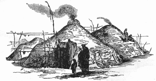
Like other earth lodge cultures of the Great Plains, the Cheyenne planted corn, squash, and beans in gardens on the flood plain of the river. There was once a great Cheyenne village at the great bend of the river in Eddy County. At some point in their history, after they moved west to the Mníšoše (Water-Astir; Missouri River), and at the turn of the nineteenth century, the Cheyenne abandoned their sedentary lifestyle in favor of a nomadic one, like the Thítȟuŋwaŋ (Teton; Plains Dwellers).


The Cheyenne River in South Dakota.

The Cheyenne moved west to the Mníšoše and lived along the river between present-day Fort Yates, ND and the present-day Cheyenne River. Their villages were abandoned a year or two before the Corps of Discovery ascended the Missouri River. But they lived there when the French arrived in the 1730s, and later when the Spanish and English arrived to trade. It was possible that disease from contact drove them west, much as smallpox drove the Mandan to move north to Knife River.

In early maps of explorers and traders, the river where the concentration of Cheyenne lived along the “Cheyenne River,” the river was named so.

What the Cheyenne called the Sheyenne River or the Cheyenne River is beyond me.

For the Lakȟóta, the Cheyenne River was known simply as Wakpá Wašté, or The Good River.

Thursday, July 25, 2013

The Origin Of Apple Creek

A view of Apple Creek, south and east of Bismarck, N.D.
The Origin of Apple Creek
Tȟaspáŋ Wakpála Ohútkȟaŋ
By Dakota Wind
BISMARCK, N.D. - I’ve often wondered about the origin of the name of Apple Creek here in North Dakota.

Apple Creek is a tributary of the Mní Šhošhé (The Water A-Stir; Missouri River), converging with it at the base of Pictured Bluff, just south of the University of Mary, off of HWY 1804.

It begins somewhere in field near Wing, ND, and winds a quiet meandering path south and west towards the Missouri. Nearly four miles east of Bismarck, about on HWY 10, is the Apple Creek Country Club. I’ve not personally been to the country club, mainly because the only golf I’ve ever played was mini, but the 18-hole golf course incorporates the natural environment, which includes the Round Leaf Hawthorn tree.

Another creek with a differing name is the Little Heart Creek, shown here with the name "Bad Water Creek," which is how the Nu'Eta (Mandan) knew it.

Apple Creek is, or was, known among the Nu’Eta (Mandan) Indians as Black Bear Creek, at least according to the Sitting Rabbit map of the Missouri River.

The Mandan used to live in the vicinity of Heart River for hundreds of years. In 1781, they were struck by a epidemic of smallpox. The survivors abandoned their villages and moved north to Knife River, where the Corps of Discovery encountered them in 1804.

Near where the Apple Creek converges with the Missouri River is where General Sibley’s command of about 4,000 soldiers relentlessly chased a group of Dakota and Lakota in a running battle that began west of present-day Jamestown, ND in mid-July, 1863 and ended at about present-day General Sibley Park in Bismarck, ND, on Aug. 2 two weeks later.

The Lakota who’ve lived on the Great Plains and who traded with the Mandan Indians knew of this meager tributary of the Mní Šhošhé. The Lakota have names for landmarks, wildlife, seasons, and rivers. And they personified all, believing – and some still do – that all these things aren’t just animated, but live and have lives of their own, that all have spirits or souls of their own too.

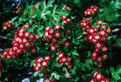
A thornapple tree, or Hawthorn, in bloom at Cashman's Nursery, Bismarck, ND.

In English, the Round Leaf Hawthorn is named for the shape of its leaf. In Latin the tree is called Crataegus cyclophylla, and I don’t know what the hell that means, but I’m sure that it means something really important to science.

In Lakota, the same tree is called Tȟaspáŋčhaŋ, which meant “Of-Red-Tree,” in reference to the dark red or swarthy color of the fruit which resemble little apples and are edible. The creek was called Tȟaspáŋ Wakpála, or as a free translation may have it, “Apple Creek.”

Mary Ann Barnes Williams’ book, “Origins Of North Dakota Place Names,” has it as the unusual name “Qui-Apelle” was given the creek by the early French-Canadians for the many Red Haw or Thorn Apple thickets bordering its banks. Another version is that the name Apple Creek is an inaccurate translation of the Dakota Indian name for it, which it [sic] Taspan Wakpala; Taspan (thorn apple), Wakpula [sic] (creek).

Monday, July 22, 2013

Devil's Heart Butte: An Enlightening Visit With A Dakota Elder


Devil's Heart Butte
The Story Of Devil's Heart Butte
By Dakota Wind
SPIRIT LAKE, N.D. - I was looking at the North Dakota state map that’s pegged to my office wall. I don’t know what it is, maybe it was a recent trip out to Heháka Wakpá Makĥoche (Elk River Country, or Theodore Roosevelt National Park) and I was in the mood to learn what the Dakota-Lakota people called places before explorers, traders, and settlers arrived.

There’s a lake in the north eastern quarter of the state. It’s a fresh water lake that’s been growing and spilling onto shore property. New islands have been formed, roads have been built higher, fields are underwater, and the water threatens to rise higher without relent.

The lake is known to the Dakota and Lakota people as Mni Wakaŋ Čhaŋté. Don’t believe Wikipedia in this, if you look it up there. A word for word translation of the Dakota to English is Water With-Energy Heart, which freely translates as Spirit Heart Lake. The calque of Bad Spirit Lake is entirely a misconception.

There, on the southern bank of the Spirit Heart Lake lay the Spirit Lake Sioux Indian Reservation, home of the Spirit Lake Oyate (Nation). The Spirit Lake Oyate has about 6,700 or so enrolled members, but not all live on the reservation.

The lake, Spirit Heart Lake (aka Devil’s Lake), the people (the Spirit Lake Oyate), have a name in common with a site on the reservation near the town of Tokio (a strange word in and of itself; said to named after the Dakota word for “Toki” for “gracious gift,” but it isn't; the closest word for gift, is in the act of receiving a gift, “Okini”). There, nestled among the rolling hills of the prairie land overlooking the lake is Spirit Heart Butte, only it’s popularly known as “Devil’s Heart Butte.”

I turned to Spirit Lake tribal historian Louie Garcia to find an answer. I’ve conversed with Louie on the phone over the years and by email. I had always thought he was perhaps a middle-aged gentleman by the youthful exuberance of his voice. Some voices age. Louie’s voice does not. He’s in his 70's, a respected member of the tribe, he’s gracious to give me an answer, and he wants me to share it with others. 

Louie has asked me to post it as he sent it to me, word for word. Pilamiya pelo, Lekshi Louie! He Even included a bibliography and a glossary of Dakota terminology (at the end of this entry).

__________


Heart Hill is a treeless kame located one mile northwest of Tokio, North Dakota in Section Four Woodlake Township (T152N – R64W) Benson County. It sits on the eastern edge of the Backbone, a line of hills formed when Spirit Lake (Devils Lake) was formed some 10,000 years ago during the last ice age. With an elevation of 1725 feet above sea level it can been seen on the horizon for miles in the lake region, and from its summit one can look over a vast area surrounding this hill. The name ‘heart’ means that it is at the center of the area but also the center of spiritual knowledge. As this hill appears to be in the shape of an upside down human heart, some incorrectly speculate this as the reason for its name.

Heart Hill is the most sacred elevation in all of North Dakota. It could be considered a cathedral. This Butte de Coeur of the French fur traders is called in the Dakota language Miniwakan Cante Paha or Heart Hill at Spirit Lake. The French fur traders named Devils Lake so that presently the term ‘devil’ is attached to many local geographical features.  “Devils Heart” is the name used by local people. Naturally the ‘devil’ word is a misunderstanding, but referring to the Water Spirits who live in the lake.

This Heart Hill is a sacred location because it is the Lodge of the Water Spirit for whom Spirit Lake is named. These spirits are called Unktehi or Terrible Ones due to their custom of drowning anyone who foolishly ventured upon the lake without their permission. These Unktehi are worshiped in the Wakan Wacipi or Grand Medicine Ceremony (Skinner 1920:273).

This hill belongs to a class of sacred lodges (hills) where the spirits meet to decide the help, if any, they will grant humans. Prehistorically the waters of the lake flowed up to the east side of this hill, to the door or entrance of this the Water Spirit’s home. The spirits could enter and exit their home to do their business within this sacred lake. Unfortunately the entrance to this sacred hill was blown closed with dynamite in the 1930’s when a local rancher discovered a den of coyotes living within. If one looks closely at the change in vegetation, the location of the former entrance can be discovered.

There are many heart hills or buttes in the state but this most important one is at Spirit Lake. Examples of other heart hills are: The Heart of the Turtle Mountain or as it is known today Butte Saint Paul. It is located in Cordella Township (13-162-74) Bottineau County. There is also a Heart Butte located on the Ft. Berthold Reservation (9-148-92) in northeastern Dunn County. Cavalier County has a Heart Butte (19-162-62), as well as Grant County (23-137-89).

Thomas F. Eastgate records in his notes two northerly connected hills who he calls ‘sisters’ to Heart Hill (Eastgate). This must be a non-Indian name or a mistranslation as features on the earth are considered male. As an example there is a Sanborn Hill  or “Heart Hill’s Little Brother” located in Heman Township (1-139-59) Barnes County named for its exact appearance but smaller stature than the hill presently under discussion.

The Spirit Lake area formerly belonged to the Hidatsa. Their main earthlodge village was located on the west end of Graham’s Island, now a peninsula jutting into northwestern Spirit Lake (Devils Lake). The Hidatsa name for Heart Hill is Mirixopa Nata Sh or Heart of the Holy Water. Hidatsa traditions acknowledge the tribe was ‘born’ at Heart Hill. In a narrative similar to the European tale of Jack and the Bean Stalk, the tribe emerged from an underworld by climbing a vine. Unfortunately the vine broke leaving half of the people in their subterranean world. The Hidatsa departed the Spirit Lake area circa 1550 when their leader was told in a dream to move west to the Missouri River (Bowers 1992:22; Milligan 1972; Libby Papers Box 29: folder 14; Kittleson 1992:15).

The Hidatsa have many Lake Region legends and tales, especially about geophysical features. One story that is remembered, tells of them making a stone effigy of a bear on the north side of Heart Hill. A bison effigy is mentioned too. Dana Wright was shown a trail of 385 stones leading 450 feet to the west from the hill (Roy Johnson Papers).

In 1839 Nicollet visited the area to map the lake and surrounding area. He drew a sketch map from the top of the hill. Today one can see the same view of Black Tiger Bay just as it was drawn some 166 years ago because little has changed (Bray and Bray 1976:192).

I have a reference to this hill in 1855 bring called Clarence Peak.
Dr. Charles Eastman writes in his book Indian Boyhood of visiting Heart Hill in the 1860’s and was informed a great medicine man named Cotanka (Reed or Flute) was buried on top (Eastman 1971:163). A man by the name of Charles Belgarde is also buried on top of the hill (St. Ann’s Centennial). In June of 1992 a group of Crow Indians from Montana ascended the hill and erected two shades for the purpose of a vision quest. A four post shade was erected on the top at the west end, and another on the east end. A year later local children began to dig in the abandoned post holes and discovered a skull and arm bones. The bones were eventually sent to the State Historical Society of North Dakota in Bismarck for evaluation (Devils Lake Journal).

Father Genin on March 4, 1868 erected a thirty three foot tin laminated oak crucifix, but it was destroyed by a prairie fire, or a wind storm. On July 22, 1873 another cross of glass and steel construction replaced the wooden cross (Cory-Forbes Papers: Box 2; Norton 1931:163). Both crosses were said to be spectacular when they reflected the suns rays. Some say that glass particles can still be found at the base of the hill, remnants of the second cross. Father Genin (Richard 1975:3) renamed the hill The Sacred Hearts of Jesus and Mary, a name closer to the original intent of the Indians. It is better than the present non-Indian name of Devils Heart (Cory-Forbes Papers: Box 2).

I was told that in1924, on a day with a clear blue sky a local church group went to Heart Hill for a picnic. They sang a hymn and the minister said a prayer, a single white cloud approached and poured hail and lighting upon them, sending them for cover. From a religious aspect one could say the Thunders were attacking the Water Spirits lodge.

Heart Hill has been used for recreational purposes during the last century. There is a photograph of a ski jump built upon the top of the hill. It has been a favorite hiking destination as well as winter sledding, especially for local school classes. By the 1930’s the ski jump was moved to a location by Highway 57 where its skeleton can be seen today. Yearly a wagon train camps for one night at the base of the hill. It is a favorite site to take visitors who have the stamina to climb to the top.

Most if not all you readers would naturally assume the Spirit Lake Tribe owns this sacred hill. You would of course be wrong. When the Spirit Lake Reservation land was allotted to individuals in accordance with the Treaty of 1872-73 and Dawes Act of 1887, no tribal member selected the hill. The ownership of land was against Indian thought. How could anyone think of owning a sacred location? No one can own land, it belongs to God. When the reservation was opened to non-Indian ownership in 1904, the hill was selected by a Whiteman and remains so today. However if we analyze the situation, this non-Indian really doesn’t own Heart Hill, all he has to do it not pay his taxes for five years.

Bibliography

Bowers, Alfred W.                   Hidatsa Social and Ceremonial Organizations.
                                                University of Nebraska Press, Lincoln and London 1992.

Bray Edmund C.                     Joseph N. Nicollet on the Plains and Prairies: Expeditions
Bray, Martha Coleman           of 1838 39 with Journals, Letter, and Notes on the Dakota
Translators and editors           Indians. Minnesota Historical Society Press, St. Paul; 1976.

Centennial Committee            St. Ann’s Centennial, 100 years of Faith 1885 – 1985
                                                Turtle Mountain Indian Reservation, Belcourt, ND

Cory – Forbes Papers                        (1853 -1927) A-C833 Box 2, Minnesota Historical Society,
                                                St. Paul. Three boxes and 10 volumes.
                                                (Father Genin and the crosses)

Devils Lake Journal                “B.I.A. Probes Bone Discovery” May 19, 1993.

Eastgate, Thomas F. Papers.             (1855-1907) Location unknown.
Formerly located in Larimore, ND.
                                                Withdrawn by family possibly to Minot, ND.

Eastman, Charles A.               Indian Boyhood.
                                                Dover Publications, Inc. New York. 1971.

Eastman, Charles A.               “The Wars of Wakeeyan and Unktayhee”
Eastman, Elaine Goodale       Wigwam Evenings: Sioux Folk Tales Retold
                                                University of Nebraska Press, Lincoln 1990. Pp. 117 – 121.

Hanson, Jeffrey R.                 “Ethnohistoric Problems in the Crow – Hidatsa
                                                Separation”
                                                Archaeology in Montana 20 (3) Pp. 7-85. Billings 1979

Kittleson, Cindy Cooper          “Legends and Lore in Devils Lake”
                                                Going Places 2 (9) September 1992 Pp 14 &15.

Libby, Orin Grant Papers        A85 State Historical Society of North Dakota, Bismarck.

Matthews, Washington           Grammar and Dictionary of the Language of the Hidatsa:
                                                Introductory Sketch of the Tribe.
Cramoisy Press, New York. 1873.

Mattison, Ray H.                     “Report on the Historic Sites in the Garrison Reservoir
                                                Area, Missouri River”.
                                                North Dakota History 22 (1&2) 1955

Milligan, Edward A.                 The Indian in the Northern Plains.
                                                North Dakota State University – Bottineau, 1972
                                                No page numbers, probably written for his classes.

Norton, Sister Mary                “Catholic Missions and Missionaries”
Aquinas O.S.F.                       North Dakota Historical Quarterly 5 (3) April 1975
                                               
Richard, Frank                                    “St. Benedict of Wild Rice”
                                                Red River Valley Historian Summer 1975.

Skinner, Alanson                     “Wahpeton Dakota Wakan Wacipi or Medicine Dance”
                                                Indian Notes and Monographs 4, 1920 Pp. 262-340.
                                                Museum of the American Indian, Heye Foundation.
                                                New York, NY.
                                                                                                           

Glossary

Backbone                    Miniwakan Cankahu (Mini = water; Wakan = sacred, holy; Canka
= back; Hu = bone). A continuous ridge on the south side of Spirit Lake beginning at Sully’s Hill, travels east to the St. Michael area and then swings south to end at the Sheyenne River.

Black Tiger Bay          Located on the south shore of Spirit Lake north of Tokio, ND
                                    Named for Igmusapa (Black Panther) DLS #482 1829 – 1915.

Butte de Couer            French: Heart Hill (Butte = hill; de = of the; Couer = heart).

Butte St. Paul              Heyatanka Cante Paha (He = mountain; Yatanka = great; Cante =
heart; Paha = hill). Heart Hill at the Great Mountain (Turtle Mountain) has an elevation of 2305 above sea level.

Cotanka                      Medicine man buried on top of Heart Hill. His name translates
                                    Reed, also whistle or flute as reeds were used for this purpose.

Eastman, Charles A.   Ohiyesa (Ohiya = to win; Sa= continually) an Eastern Dakota
                                    who fled to Canada via Spirit Lake as a boy. He later became a
                                    medical doctor.

Genin, Father              Jean-Baptiste Genin an Oblate missionary was born in France 1837. Immigrated to Canada in 1860, in 1865 he journeyed to St. Boniface (Winnipeg, Manitoba), May 7, 1865 went to Ft. Abercrombie which later became his headquarters. He didn’t get along with the settlers because as soon as he selected land for an Indian mission squatters would take the land. The administering to Indians became a bone of contention with Bishop Shanley of Fargo, a new comer who wanted Genin to establish non-Indian churches. He did establish churches at White Earth, Detroit Lakes,
                                    and Moorhead, MN. He died at Bathgate, ND; January 18, 1900
                                    (Richard 1975).

Graham’s Island          Named for Duncan Graham, a Scottish fur trader who operated a post on the island circa 1815. His Indian name was Hoarse Voice
                                    (Hoġita) probably named for his brogue.

Heart Hill                     Miniwakan Cante Paha (MiniWakan = sacred water; Cante = heart;
Paha = hill), located in the Northwest quarter of the northwest quarter of Section four, Woodlake Township, Benson County.

Hidatsa                        The Red Willow People, meaning they were tall and slender as the
                                    Red Willow. They gathered at the mouth of the Knife River where
it enters the Missouri River near present Stanton, ND (Mercer County) is today in three villages. The River Crow separated from the Big Hidatsa Village (Midahati Sh = Willow Village) and the Mountain Crow separated from Sakakawia Village (Awatixa Sh = Elongated Village) (Mattison 1955:22-23; Hanson 1979).

Kame                          Sand and gravel deposited by the melting glacial ice. A hole in the
                                    ice sheet would be filled with sand and gravel. When the ice sheet
                                    melted, the result was a hill. Geologists use the term kame.

Mirixopa Nata Sh        Hidatsa for Heart Hill (Miri = water; Xopa = holy, sacred; Nata =
Heart; Sh = definite article [the] used for personal names and places) (Matthews1873).
                                                                                                           
Sanborn Hill                Miniwakan Cante Paha Sunkaku (Miniwakan = Sacred Water [Spirit Lake]; Cante = heart; Paha = hill; Sunkaku = his younger
                                    Brother) The younger brother of the Heart Hill at Spirit Lake.

Unktehi                        Water Spirit (Un = to be; K = inserted for euphony; Teĥike = terrible, difficult). The Difficult (to deal with) One. The Water

Spirits are the meniscus of the Thunders. Their battles explain the hydrological cycle (Eastman and Eastman 1990).

Wright, Dana               He was the premier historian for the state of North Dakota.
                                    His primary interest was military trails, publishing his findings
                                    in North Dakota History in the 1950’s.